-
Laboratory soil incubation respiration rates from permafrost in subarctic Canada, 2013 & 2014
This dataset contains measures of laboratory soil incubation respiration rates from permafrost in subarctic Canada. Soil cores were sampled from a peatland plateau and a thawing...
-
Greenhouse gas production and soil chemistry in soil Incubations after nitrogen addition, Seward Peninsula, 2018-2019
This dataset provides the results of laboratory soil microcosm incubation experiments conducted under anaerobic conditions with and without the addition of ammonium chloride...
-
Methane fluxes from burnt and unburnt forests from permafrost in subarctic Canada, 2013 & 2014
This dataset contains methane fluxes from peatland plateaus and thawing peatland plateaus and from burnt and unburnt forests from permafrost in subarctic Canada. Methane fluxes...
-
Soil respired radiocarbon as CO2 and CH4 from permafrost in subarctic Canada, 2013 & 2014
This dataset contains measures of soil respired radiocarbon as CO2 and CH4 from peatland plateaus and thawing peatland plateaus and from burnt and unburnt forests from...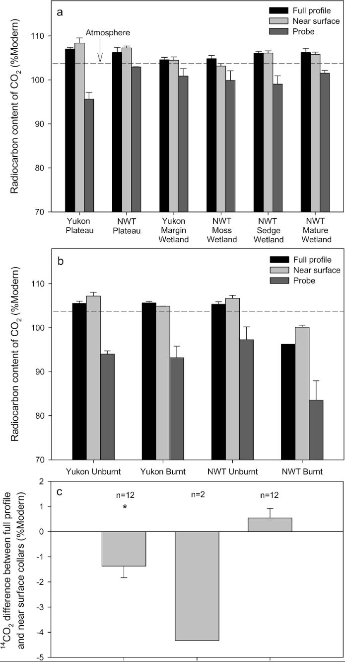
-
Geochemistry of incubated permafrost and seawater from the western Canadian Arctic
We present geochemical and hydrochemical information on individual permafrost and seawater samples from the Yukon Coast in the western Canadian Arctic used for an incubation...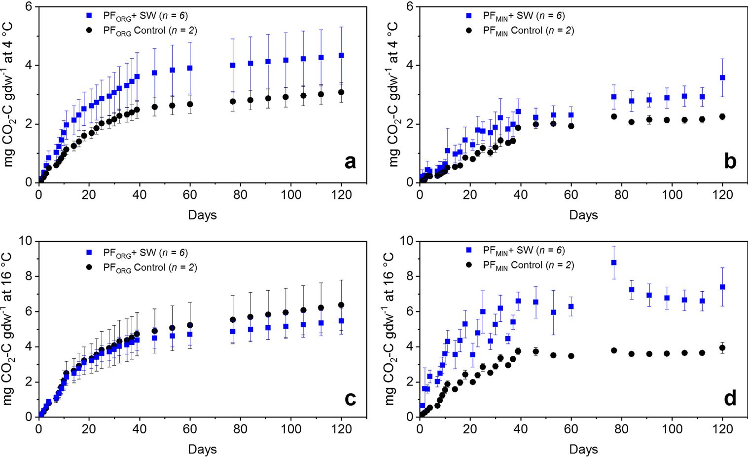
-
Anaerobic incubation measurements (CH4+CO2) and microbe quantification, Lena Delta, 2018
The data sets were made during the summer 2021, with samples collected from three cores, at two depths (active and permafrost layers). In total, six samples (3 replicates by...
-
ABoVE: Methane Ebullition Hotspots in Frozen Lakes near Fairbanks, Alaska, Oct 2014
This dataset includes maps of the locations and number of methane ebullition hotspots in 15 frozen lakes in the southern portion of the Goldstream Valley and the surrounding...
-
Arctic Coastal Human Impact dataset (SACHI) derived from Sentinel-1/2, 2016-2020, Circum-Arctic
The SACHI (Sentinel-1/2 derived Arctic Coastal Human Impact) V1 dataset was developed as part of the HORIZON2020 project Nunataryuk by b.geos (www.bgeos.com). V1 covered a 100km... -
Developing and Testing a Deep Learning Approach for Mapping Retrogressive Thaw Slumps (CA, RU)
In a warming Arctic, permafrost-related disturbances, such as retrogressive thaw slumps (RTS), are becoming more abundant and dynamic, with serious implications for permafrost...
-
TCCON data from Sodankylä, Lapland (FI), Release GGG2020.R0
The Total Carbon Column Observing Network (TCCON) is a network of ground-based Fourier Transform Spectrometers that record direct solar absorption spectra of the atmosphere in... -
UAV-based methane data from Barter Island, September 2017, Barrow, 1986-2017, Alaska (US)
Arctic permafrost stores vast amounts of methane (CH4) in subsurface reservoirs. Thawing permafrost creates areas for this potent greenhouse gas to be released to the...
-
Surface Soil Moisture from ENVISAT ASAR GM, 2005-2010, Laptev Sea Coast, Laptev and East Siberian Sea Region (RU)
The SAR Surface Soil Moisture (SSM) product is derived from the ENVISAT ASAR sensor operating in Global Monitoring (GM) mode. The SAR SSM product is a weekly mean composite at 1...
-
Surface Soil Moisture from ENVISAT ASAR GM, 2005-2011, Mackenzie River Valley and Delta, Beaufort Sea Region (CA)
The SAR Surface Soil Moisture (SSM) product is derived from the ENVISAT ASAR sensor operating in Global Monitoring (GM) mode. The SAR SSM product is a weekly mean composite at 1...
-
Surface Soil Moisture from ENVISAT ASAR GM, 2005-2011, Ob Estuary and Yamal Peninsula, Western Siberia (RU)
The SAR Surface Soil Moisture (SSM) product is derived from the ENVISAT ASAR sensor operating in Global Monitoring (GM) mode. The SAR SSM product is a weekly mean composite at 1...
-
Water Body Classification from ENVISAT ASAR Wide Swath, 2007-2011, Lena Delta / East Taymir / Cherskii, Laptev and...
The regional waterbody classification is derived from ENVISAT ASAR Wide Swath data with 150 m resolution. Maps represent the extent of water bodies for the summer months July...
-
Water Body Classification from ENVISAT ASAR Wide Swath, 2007-2011, Ob Estuary and Yamal Peninsula, Western Siberia (RU)
The regional waterbody classification is derived from ENVISAT ASAR Wide Swath data with 150 m resolution. Maps represent the extent of water bodies for the summer months July...
-
Ground Temperature Map, 2000-2016, New Zealand
The product provides modeled mean annual ground temperatures (MAGT) at the top of the permafrost for New Zealand at 1 km spatial resolution. Permafrost probability (fraction...
-
Surface Soil Moisture from ENVISAT ASAR GM, 2005-2011, Yakutsk, Central Yakutia (RU)
The SAR Surface Soil Moisture (SSM) product is derived from the ENVISAT ASAR sensor operating in Global Monitoring (GM) mode. The SAR SSM product is a weekly mean composite at 1...
-
Water Body Classification from ENVISAT ASAR Wide Swath, 2007-2008, Yakutsk, Central Yakutia (RU)
The regional waterbody classification is derived from ENVISAT ASAR Wide Swath data with 150 m resolution. Maps represent the extent of water bodies for the summer months July...
-
Water Body Classification from ENVISAT ASAR Wide Swath, 2007-2011, Mackenzie River Valley and Delta, Beaufort Sea Region (CA)
The regional waterbody classification is derived from ENVISAT ASAR Wide Swath data with 150 m resolution. Maps represent the extent of water bodies for the summer months July...