-
Gridded monthly methane emissions from terrestrial wetlands, north of 45 °N, 2013-2014
This dataset provides wetland methane (CH4) emissions, their uncertainties and underlying CH4 flux densities north from 45 N using three different wetland maps. The data...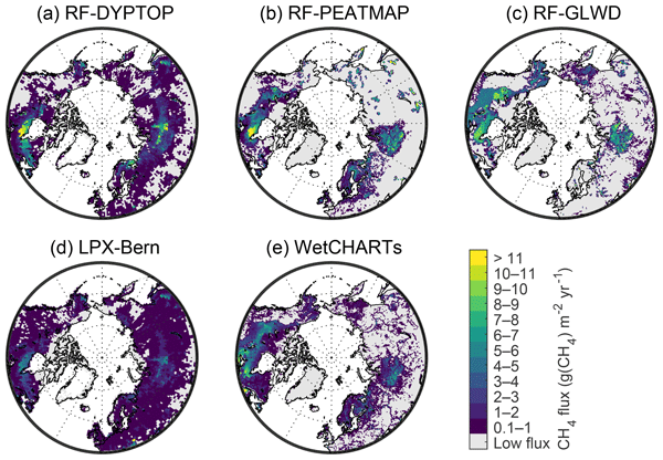
-
Global 0.5-deg Wetland Methane Emissions and Uncertainty (WetCHARTs v1.0), 2009-2010
This data set provides global monthly wetland methane (CH4) emissions and uncertainty data products derived from an ensemble of multiple terrestrial biosphere models, wetland...
-
Monthly Land Surface Temperature from MODIS, 2007-2013, Circum-Arctic Region
Monthly land surface temperature (LST) products of the ESA Data User Element (DUE) Permafrost are provided at 1 km spatial resolution for the
Monthly Land Surface Temperature from MODIS, 2007-2013, Ob Estuary and Yamal Peninsula, Western Siberia (RU)
Monthly land surface temperature (LST) products of the ESA Data User Element (DUE) Permafrost are provided at 1 km spatial resolution for the
Monthly Land Surface Temperature from MODIS, 2007-2013, Laptev Sea Coast, Laptev and East Siberian Sea Region (RU)
Monthly land surface temperature (LST) products of the ESA Data User Element (DUE) Permafrost are provided at 1 km spatial resolution for the
Monthly Land Surface Temperature from MODIS, 2007-2013, Mackenzie River Valley and Delta, Beaufort Sea Region (CA)
Monthly land surface temperature (LST) products of the ESA Data User Element (DUE) Permafrost are provided at 1 km spatial resolution for the
Monthly Land Surface Temperature from MODIS, 2007-2013, Alaska North Slope and Alaska Highway, Alaska (US)
Monthly land surface temperature (LST) products of the ESA Data User Element (DUE) Permafrost are provided at 1 km spatial resolution for the