-
Polygonal Tundra Geomorphology Map from Landsat time series, 2014, Alaskan Arctic Coastal Plain (US)
We mosaicked twelve LandSat-8 OLI satellite images taken during the summer of 2014, which were used in an object based image analysis (OBIA) to classify the landscape. We mapped...
-
NDVI trend from Landsat time series, 1999-2014, Alaskan Arctic Coastal Plain (US)
Normalized difference vegetation index (NDVI) trend map was computed for the Alaskan Arctic Coastal Plain between 1999 and 2014. The decadal trend of each pixel was computed... -
Ice wedge polygon occurrence and geomorphology from LiDAR elevation data, 2012 and 2014, south of Prudhoe Bay, Alaska (US)
We mapped the occurrence of more than one million ice wedge polygons over a landscape of approximately 1,200 square kilometers, just south of Prudhoe Bay in northern Alaska,...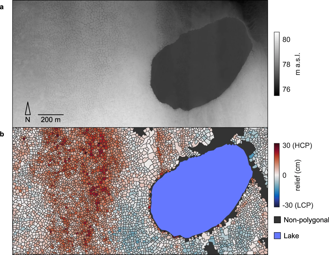
-
Pan-Arctic Visualization of Landscape Change (2003-2022), Arctic PASSION Permafrost Service
This raster dataset, in Cloud Optimized GeoTIFF format (COG), provides information on land surface changes at the pan-arctic scale. Multispectral Landsat-5 TM, Landsat-7 ETM+,...
-
Northern Circumpolar Soil Carbon Database, Alaska, geotiff- and netCDF-files
The Northern Circumpolar Soil Carbon Database version 2 (NCSCDv2) is a geospatial database created for the purpose of quantifying storage of organic carbon in soils of the...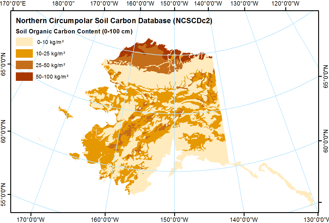
-
Surface Soil Moisture from ENVISAT ASAR GM, 2005-2010, Laptev Sea Coast, Laptev and East Siberian Sea Region (RU)
The SAR Surface Soil Moisture (SSM) product is derived from the ENVISAT ASAR sensor operating in Global Monitoring (GM) mode. The SAR SSM product is a weekly mean composite at 1...
-
Surface Soil Moisture from ENVISAT ASAR GM, 2005-2011, Mackenzie River Valley and Delta, Beaufort Sea Region (CA)
The SAR Surface Soil Moisture (SSM) product is derived from the ENVISAT ASAR sensor operating in Global Monitoring (GM) mode. The SAR SSM product is a weekly mean composite at 1...
-
Surface Soil Moisture from ENVISAT ASAR GM, 2005-2011, Ob Estuary and Yamal Peninsula, Western Siberia (RU)
The SAR Surface Soil Moisture (SSM) product is derived from the ENVISAT ASAR sensor operating in Global Monitoring (GM) mode. The SAR SSM product is a weekly mean composite at 1...
-
Water Body Classification from ENVISAT ASAR Wide Swath, 2007-2011, Lena Delta / East Taymir / Cherskii, Laptev and...
The regional waterbody classification is derived from ENVISAT ASAR Wide Swath data with 150 m resolution. Maps represent the extent of water bodies for the summer months July...
-
Water Body Classification from ENVISAT ASAR Wide Swath, 2007-2011, Ob Estuary and Yamal Peninsula, Western Siberia (RU)
The regional waterbody classification is derived from ENVISAT ASAR Wide Swath data with 150 m resolution. Maps represent the extent of water bodies for the summer months July...
-
Ground Temperature Map, 2000-2016, New Zealand
The product provides modeled mean annual ground temperatures (MAGT) at the top of the permafrost for New Zealand at 1 km spatial resolution. Permafrost probability (fraction...
-
Surface Soil Moisture from ENVISAT ASAR GM, 2005-2011, Yakutsk, Central Yakutia (RU)
The SAR Surface Soil Moisture (SSM) product is derived from the ENVISAT ASAR sensor operating in Global Monitoring (GM) mode. The SAR SSM product is a weekly mean composite at 1...
-
Water Body Classification from ENVISAT ASAR Wide Swath, 2007-2008, Yakutsk, Central Yakutia (RU)
The regional waterbody classification is derived from ENVISAT ASAR Wide Swath data with 150 m resolution. Maps represent the extent of water bodies for the summer months July...
-
Water Body Classification from ENVISAT ASAR Wide Swath, 2007-2011, Mackenzie River Valley and Delta, Beaufort Sea Region (CA)
The regional waterbody classification is derived from ENVISAT ASAR Wide Swath data with 150 m resolution. Maps represent the extent of water bodies for the summer months July...
-
Land Cover Classification from Sentinel-1 and Sentinel-2, 2015-2018, Mackenzie Delta, Beaufort Sea Region (CA)
Land cover classes have been derived from bands of Sentinel-2 (bands 3 (green, 10m), 4 (red, 10m), 8 (near infrared, 10m), 11 (SWIR, 20m) and 12 (SWIR, 20m)) as well as...
-
Frozen State Backscatter Intensity from Sentinel-1, 2016-2017, Mackenzie Delta, Beaufort Sea Region (CA)
Frozen state backscatter intensity was derived from Sentinel-1 acquisitions from December 2015 and 2016. By excluding the effects of liquid water content (acquisitions under...
-
Land Surface Feature Classification from TerraSAR-X, 2013, Lena Delta, Laptev and East Siberian Sea Region (RU)
Land surface features (water, wetland, tundra, and bare surfaces) were classified from TerraSAR-X with a resolution of 5 m for August 2012 and July 2014. The product is based on...
-
Circumarctic wetland dataset based on ENVISAT ASAR Global Monitoring Mode, 2005-2011, Panarctic
A circumpolar representative and consistent wetland map is required for a range of applications ranging from upscaling of carbon fluxes and pools to climate modelling and...
-
Vegetation map of Trail Valley Creek from airborne orthophotos, laser scanning and field work data, Northwest...
The vegetation map distinguishes between five tundra vegetation types, trees, and open water at the forest-tundra transition north of Inuvik, Northwest Territories, Canada. The...
-
A high spatial resolution soil carbon and nitrogen dataset for the northern permafrost region
This spatial dataset is quantifying soil organic carbon (SOC) and total nitrogen (TN) storage with their carbon to nitrogen ratio (C/N) in soils of the northern circumpolar...