-
40-year monthly mean AVHRR GAC Land Surface Temperature data for the Pan-Arctic region (Pan-Arctic AVHRR LST)
This data collection contains 40 years of monthly mean daytime AVHRR Global Area Coverage (GAC) land surface temperature (LST) data. This dataset covers the 1981-2020 perdiod...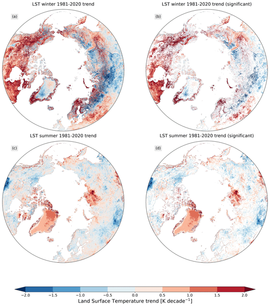
-
Super-high-resolution aerial imagery, digital surface model and 3D point cloud of Cape Blossom, Alaska (7 cm)
As part of the Perma-X airborne campaign led by the Alfred Wegener Institute in 2021, we collected super-high-resolution multispectral imagery of permafrost landscapes with the...
-
Super-high-resolution aerial imagery, digital surface model and 3D point cloud of Cape Blossom, Alaska (10 cm)
As part of the Perma-X airborne campaign led by the Alfred Wegener Institute in 2021, we collected super-high-resolution multispectral imagery of permafrost landscapes with the...
-
Super-high-resolution aerial imagery, digital surface model and 3D point cloud of Cape Blossom, Alaska (20 cm)
As part of the Perma-X airborne campaign led by the Alfred Wegener Institute in 2021, we collected super-high-resolution multispectral imagery of permafrost landscapes with the...
-
Super-high-resolution aerial imagery, digital surface model and 3D point cloud of Trail Valley Creek, Canada (subset 08)
As part of the MOSES airborne campaign led by the Alfred Wegener Institute in 2018, we collected super-high-resolution multispectral imagery of permafrost landscapes with the...
-
Super-high-resolution aerial imagery, digital surface model and 3D point cloud of Trail Valley Creek, Canada (subset 07)
As part of the MOSES airborne campaign led by the Alfred Wegener Institute in 2018, we collected super-high-resolution multispectral imagery of permafrost landscapes with the...
-
Super-high-resolution aerial imagery, digital surface model and 3D point cloud of Trail Valley Creek, Canada (subset 06)
As part of the MOSES airborne campaign led by the Alfred Wegener Institute in 2018, we collected super-high-resolution multispectral imagery of permafrost landscapes with the...
-
Super-high-resolution aerial imagery, digital surface model and 3D point cloud of Trail Valley Creek, Canada (subset 05)
As part of the MOSES airborne campaign led by the Alfred Wegener Institute in 2018, we collected super-high-resolution multispectral imagery of permafrost landscapes with the...
-
Super-high-resolution aerial imagery, digital surface model and 3D point cloud of Trail Valley Creek, Canada (subset 04)
As part of the MOSES airborne campaign led by the Alfred Wegener Institute in 2018, we collected super-high-resolution multispectral imagery of permafrost landscapes with the...
-
Super-high-resolution aerial imagery, digital surface model and 3D point cloud of Trail Valley Creek, Canada (subset 03)
As part of the MOSES airborne campaign led by the Alfred Wegener Institute in 2018, we collected super-high-resolution multispectral imagery of permafrost landscapes with the...
-
Super-high-resolution aerial imagery, digital surface model and 3D point cloud of Trail Valley Creek, Canada (subset 02)
As part of the MOSES airborne campaign led by the Alfred Wegener Institute in 2018, we collected super-high-resolution multispectral imagery of permafrost landscapes with the...
-
Super-high-resolution aerial imagery, digital surface model and 3D point cloud of Trail Valley Creek, Canada (subset 01)
As part of the MOSES airborne campaign led by the Alfred Wegener Institute in 2018, we collected super-high-resolution multispectral imagery of permafrost landscapes with the...
-
Super-high-resolution aerial imagery, digital surface model and 3D point cloud of the Southern Noatak Valley, Alaska...
As part of the Perma-X airborne campaign led by the Alfred Wegener Institute in 2021, we collected super-high-resolution multispectral imagery of permafrost landscapes with the...
-
Super-high-resolution aerial imagery, digital surface model and 3D point cloud of the Southern Baldwin Peninsula,...
As part of the Perma-X airborne campaign led by the Alfred Wegener Institute in 2021, we collected super-high-resolution multispectral imagery of permafrost landscapes with the...
-
Super-high-resolution aerial imagery, digital surface model and 3D point cloud of the Southern Baldwin Peninsula,...
As part of the Perma-X airborne campaign led by the Alfred Wegener Institute in 2021, we collected super-high-resolution multispectral imagery of permafrost landscapes with the...
-
Super-high-resolution aerial imagery, digital surface model and 3D point cloud of the Southern Baldwin Peninsula,...
As part of the Perma-X airborne campaign led by the Alfred Wegener Institute in 2021, we collected super-high-resolution multispectral imagery of permafrost landscapes with the...
-
Super-high-resolution aerial imagery, digital surface model and 3D point cloud of the Northern Teshekpuk Lake,...
As part of the ThawTrend-Air airborne campaign led by the Alfred Wegener Institute in 2019, we collected super-high-resolution multispectral imagery of permafrost landscapes...