-
Dissolved methane and hydrochemical parameters in ice cores from 2017, Bykovsky Peninsula, Lena Delta
Data were analyzed to study the role of an winter ice cover for methane cycles of three different stages in the lake-lagoon-shelf transition in a region of rapidly thawing... -
Methane and nitrous oxide sea-air fluxes calculated from samples collected in the North American Arctic Ocean (2015–2018)
This dataset contains methane and nitrous oxide dissolved gas concentration, dissolved methane carbon isotope, and ancillary hydrographic data from research cruises in the North... -
Chamber measured methane transport through individual aerenchymous plants at a boreal fen and a bog
The presented dataset contains chamber measurements of methane transport (mg CH₄ g dry plant mass-1 day-1) through individual aerenchymous peatland plants and the ancillary data... -
Methane fluxes, soil gas profiles and microbial activities in ponds at Samoylov, 2002 & 2013
Methane (CH4) production, oxidation, and emission were studied in ponds of the permafrost-affected polygonal tundra in northeast Siberia. Summer CH4 fluxes were measured with... -
Soil incubation data from ice-rich permafrost deposits in Northeast Siberia, 2014
CO2 and CH4 production in aerobic and anaerobic incubation in sediments samples from Muostakh Island (sample code MUO12), the Buor Khaya Peninsula (BK8), and Bol'shoy Lyakhovsky... -
Soil and incubation data of permafrost-affected soils in Samoylov, 2011 & 2013
The effects of oxygen availability, freezing and thawing, temperature, and labile organic matter (OM) additions on greenhouse gas production were studied in northeast Siberian... -
Geochemistry of incubated permafrost and seawater from the western Canadian Arctic
We present geochemical and hydrochemical information on individual permafrost and seawater samples from the Yukon Coast in the western Canadian Arctic used for an incubation... -
UAV-based methane data from Barter Island, September 2017, Barrow, 1986-2017, Alaska (US)
Arctic permafrost stores vast amounts of methane (CH4) in subsurface reservoirs. Thawing permafrost creates areas for this potent greenhouse gas to be released to the... -
Ground Temperature Map, 2000-2016, New Zealand
The product provides modeled mean annual ground temperatures (MAGT) at the top of the permafrost for New Zealand at 1 km spatial resolution. Permafrost probability (fraction... -
Temperature and salinity in the surface water during 4 expeditions from spring to fall in 2019, Mackenzie Delta Region (CA)
During Leg 1, the CTD (CTD RBR Maestro) was manually lowered in the water through an ice hole. During legs 2 to 4, the CTD (CTD RBR Concerto) was installed on a Seabird... -
Hydrographic (CTD) profiles during 4 expeditions from spring to fall in 2019, Mackenzie Delta Region (CA)
During Leg 1, the CTD (CTD RBR Maestro) was manually lowered in the water through an ice hole with a velocity of less than 0.3 ms-1 and an acquisition frequency of 6 Hz,... -
Isotopic composition of ground ice, ebullition gases and thermokarst lake water, Alaska, 2008-2010
Thermokarst lakes are thought to have been an important source of methane (CH4) during the last deglaciation when atmospheric CH4 concentrations increased rapidly. Here we... -
Methane and nitrous oxide dissolved gas concentrations in seawater from the North American Arctic Ocean (2015–2018)
This dataset contains methane and nitrous oxide dissolved gas concentration, dissolved methane carbon isotope, and ancillary hydrographic data from research cruises in the North... -
Methane and nitrous oxide dissolved gas concentrations from rivers in the North American Arctic (2017–2019)
This dataset contains methane and nitrous oxide dissolved gas concentration and dissolved methane carbon isotope data from rivers in the Canadian Arctic Archipelago region... -
Distribution of pingos from an IfSAR digital surface model, 2002-2006, western Arctic Coastal Plain, Northern Alaska (US)
A detailed attributed point feature shapefile of 1247 pingo locations was manually assembled from a 5m resolution digital surface model (DSM) derived from an airborne... -
Database of Global Peatland Extent and Carbon Stocks through the Last Glacial Cycle (130 ka to present)
We present the first synthesis of global peatland extent through the last glacial cycle (130 ka) based on >975 detailed stratigraphic descriptions from exposures, soil pits,... -
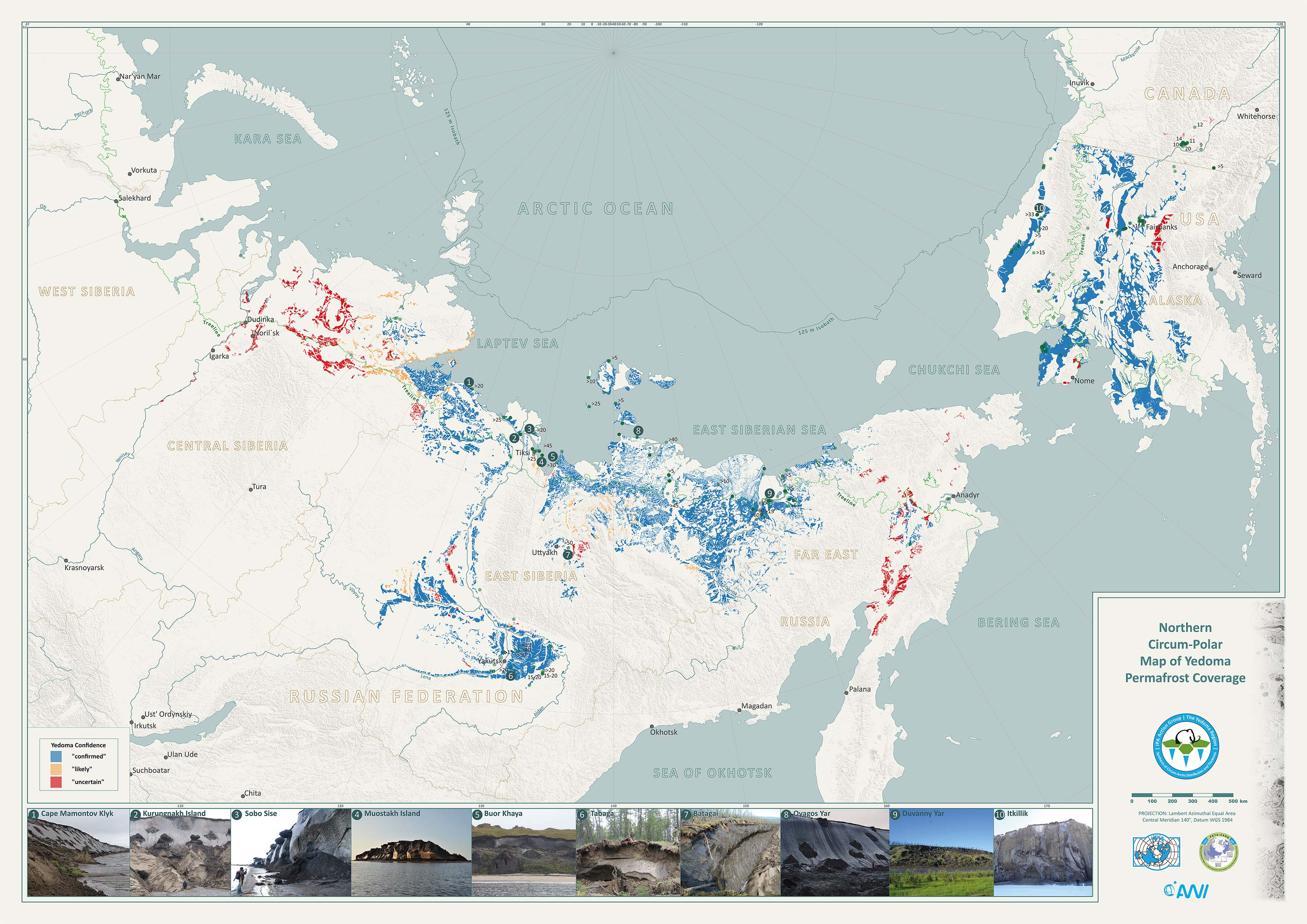
Database of Ice-Rich Yedoma Permafrost Version 2 (IRYP v2)
Ice-rich permafrost in the circum-Arctic and sub-Arctic, such as late Pleistocene Yedoma, are especially prone to degradation due to climate change or human activity. When... -
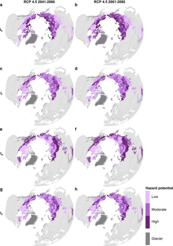
Circumpolar raster grids of permafrost extent and geohazard potential for near-future climate scenarios
One of the consequences of warming climate is rising ground temperatures and degradation of perennially frozen ground, permafrost. Thawing of near-surface permafrost can cause...


