-
Content of carbon isotopes (¹³C and ¹⁴C) in organic carbon pools in terrestrial Siberia
The dataset consists of one xlsx file with four sheets, listing (1) ¹³C and ¹⁴C data of litter and organic layers in northern Russia, Scandinavia, Canada and Alaska; (2) ¹³C and...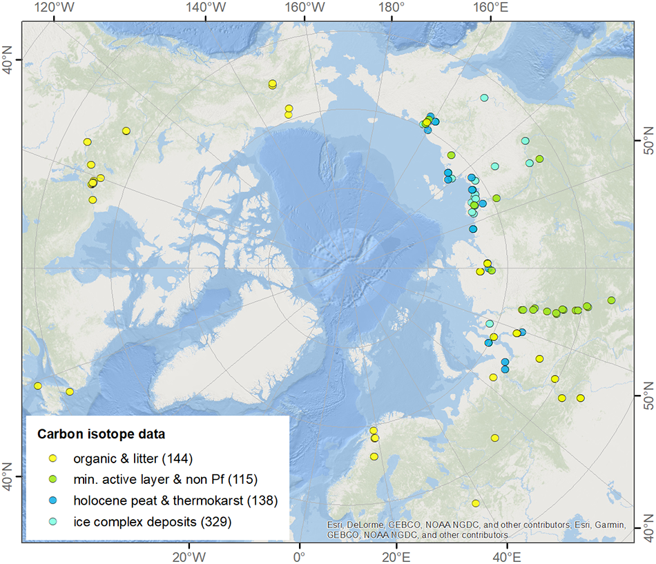
-
NDVI trend from Landsat time series, 1999-2014, Alaskan Arctic Coastal Plain (US)
Normalized difference vegetation index (NDVI) trend map was computed for the Alaskan Arctic Coastal Plain between 1999 and 2014. The decadal trend of each pixel was computed...
-
DARTS: Multi-year database of AI detected retrogressive thaw slumps (RTS) and active layer detachment slides (ALD)...
This dataset, called DARTS, comprises footprints of retrogressive thaw slump (RTS) and active layer detachments slides (ALD) identified and quantified using an automated deep...
-
Pan-Arctic thermokarst lagoon distribution, area and classification from Landsat images, 1984 to 2021
Thermokarst lagoons develop in permafrost lowlands along the ice-rich Arctic coast when thermokarst lakes or basins with bottom elevations at or below sea level are breached by...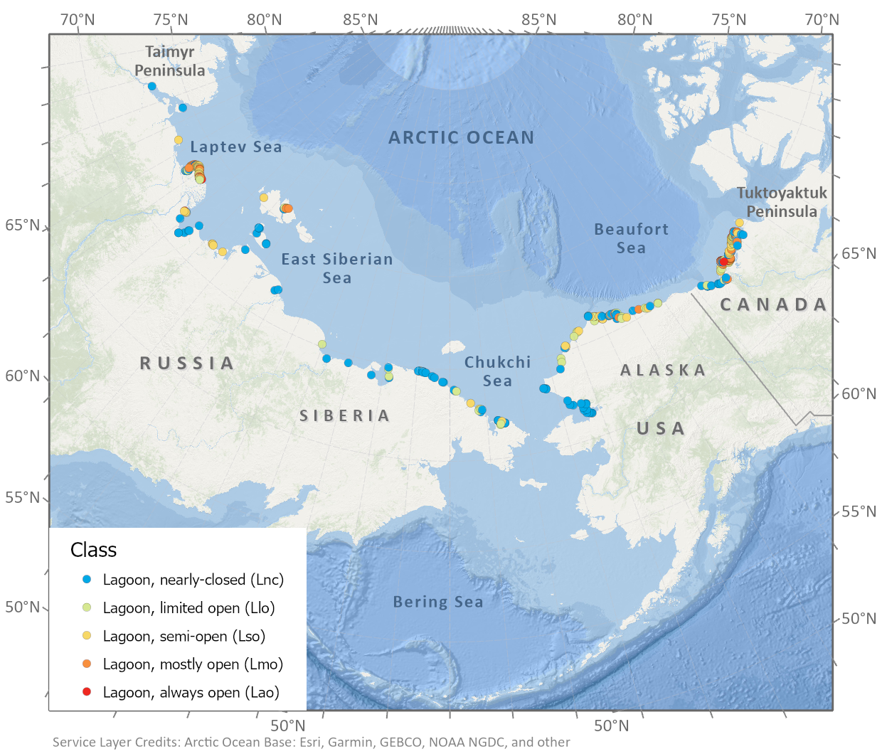
-
Spatial lake dynamics and lake-ice datasets of the Northern Seward and Baldwin Peninsulas in Alaska
The data publication contains supplementary data to the article "Supplementary Dataset to: The catastrophic thermokarst lake drainage events of 2018 in northwestern Alaska:...
-
Pan-Arctic Visualization of Landscape Change (2003-2022), Arctic PASSION Permafrost Service
This raster dataset, in Cloud Optimized GeoTIFF format (COG), provides information on land surface changes at the pan-arctic scale. Multispectral Landsat-5 TM, Landsat-7 ETM+,...
-
Pingo Database, 2022, Svalbard (NO)
The data contains the list of pingo and pingo-like forms over Svalbard archipelago. Each pingo is assigned with following data: coordinates, absolute height of pingo baseline,...
-
Distribution and morphometry of pingos, western Canadian Arctic, Northwest Territories, (CA)
GIS shape files including spatial and morphometric data of pingos in the western Canadian Arctic and accompanying Excel spreadsheet summarizing metrics for pingos of differing...
-
Inorganic and organic hydrochemistry of lakes and ponds in continuous permafrost landscapes in the western Canadian...
Between 2006 and 2015 inorganic and organic hydrochemical parameters and stable water isotope characteristics were measured in lakes and ponds in continuous permafrost...
-
Methane Fluxes from Shorelines and Differing Surfaces, 2019, Big Trail Lake, Alaska (US)
This dataset provides methane fluxes from hot-spot and non-hot spot differing surfaces at Big Trail Lake (BTL) in the Goldstream Valley near Fairbanks, AK, USA. Measurements...
-
Raster Circumpolar Arctic Vegetation Map (CAVM) from AVHRR, MODIS and elevation data
Land cover maps are the basic data layer required for understanding and modeling ecological patterns and processes. The Circumpolar Arctic Vegetation Map (CAVM), produced in...
-
Lake-DOC Database (PeRL-DOCv1), 1979-2017, Permafrost-Region
The pan-Arctic Permafrost-Region Lake-DOC version1 database contains surface water samples of lakes in the permafrost regions of Alaska (49.3 %), Canada (24.2 %), Greenland (3.2...
-
Lake Database from Landsat TM and ETM+,1970s, 2000s, 2013-2014, Western Alaska (US)
This vector data layer covers 6 major lake districts (Baldwin Peninsula, Kobuk Delta, Selawik Lowland, Northern Seward Peninsula, Central Seward Peninsula, and Yukon-Kuskokwim...
-
Mapped thermokarst ice wedge polygon patterns from WorldView-1, 2009, Ebe-Basyn-Sise Island, SW Lena Delta, Siberia (RU)
Detailed calculations of ground-ice volumes in permafrost deposits are necessary to understand and quantify the response of permafrost landscapes to thermal disturbance and...
-
Database of Quaternary Deposits from Maps, East and Central Siberia (RU)
This digital database is the product of collaboration between the U.S. Geological Survey, the Alfred Wegener Institute for Polar and Marine Research Potsdam, Foothill College...
-
Ground ice maps from paleogeographic modelling approach, Canada (CA)
Ground ice melt caused by climate-induced permafrost degradation may trigger significant ecological change, damage infrastructure, and alter biogeochemical cycles. The...
-
Geochemical, lithological, and geochronological characteristics of sediment samples from Yedoma and thermokarst...
This dataset merges data from the yedoma domain in Northern Siberia (RU) and Alaska (US). It includes numerous fieldwork campaigns, which take place since 1998 . In total 224...
-
Permafrost active layer thickness for the Northern Hemisphere, v3.0 from MODIS LST, ERA5, 1997-2019
This dataset contains permafrost active layer thickness data produced as part of the European Space Agency's (ESA) Climate Change Initiative (CCI) Permafrost project. It forms...
-
Annual dynamics of rapid permafrost disturbances from Landsat and Sentinel-2, 2000-2019, Northeast Siberia (RU)
Permafrost is warming globally which leads to widespread permafrost thaw. Particularly ice-rich permafrost is vulnerable to rapid thaw and erosion, impacting whole landscapes...
-
Satellite Photo Mosaic from Corona-KH4, 1962-06-28, Northern Seward Peninsula, Alaska (US)
This raster dataset is a high-resolution mosaic of 4 Corona-KH4 satellite photos over the northern Seward Peninsula in Northwest Alaska dated to 28 July 1962. The mosaic covers...