-
Database of Ice-Rich Yedoma Permafrost Version 2 (IRYP v2)
Ice-rich permafrost in the circum-Arctic and sub-Arctic, such as late Pleistocene Yedoma, are especially prone to degradation due to climate change or human activity. When...
-
DARTS: Multi-year database of AI detected retrogressive thaw slumps (RTS) in hotspots of the circum-arctic...
This dataset, called DARTS, comprises footprints of active parts of retrogressive thaw slump (RTS) identified and quantified using an automated deep learning approach in RTS...
-
DARTS: Multi-year database of AI detected retrogressive thaw slumps (RTS) and active layer detachment slides (ALD)...
This dataset, called DARTS, comprises footprints of retrogressive thaw slump (RTS) and active layer detachments slides (ALD) identified and quantified using an automated deep... -
Content of carbon isotopes (¹³C and ¹⁴C) in organic carbon pools in terrestrial Siberia
The dataset consists of one xlsx file with four sheets, listing (1) ¹³C and ¹⁴C data of litter and organic layers in northern Russia, Scandinavia, Canada and Alaska; (2) ¹³C and...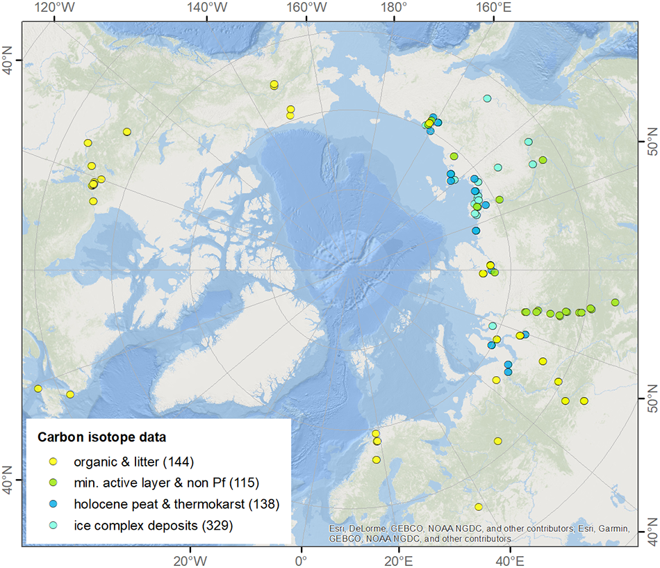
-
Ice wedge polygon occurrence and geomorphology from LiDAR elevation data, 2012 and 2014, south of Prudhoe Bay, Alaska (US)
We mapped the occurrence of more than one million ice wedge polygons over a landscape of approximately 1,200 square kilometers, just south of Prudhoe Bay in northern Alaska,...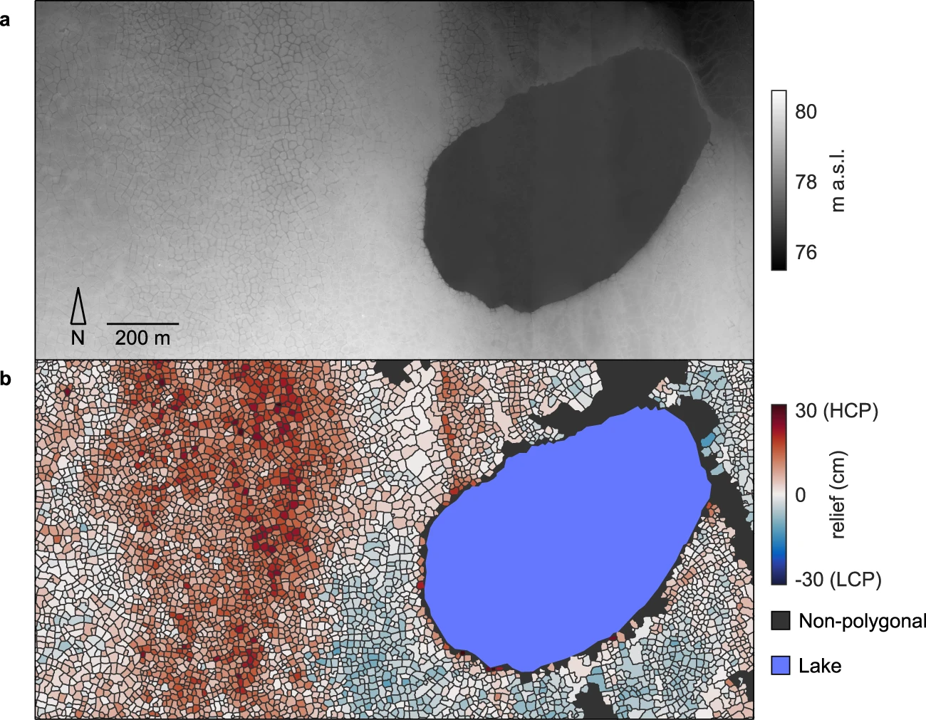
-
Pan-Arctic Visualization of Landscape Change (2003-2022), Arctic PASSION Permafrost Service
This raster dataset, in Cloud Optimized GeoTIFF format (COG), provides information on land surface changes at the pan-arctic scale. Multispectral Landsat-5 TM, Landsat-7 ETM+,...
-
Quaternary deposits map of Yana-Indigirka and Kolyma lowlands tundra zone, R-55-57, based on Landsat imagery
The Quaternary geology map was created for the Yana-Indigirka (eastern part) and Kolyma lowlands, tundra and partly forest-tundra zones. The map corresponds to the nomenclature...
-
Circumpolar Thermokarst Landscapes, 2015, Circum-Arctic
This data set provides the distribution of thermokarst landscapes in the boreal and tundra ecoregions within the northern circumpolar permafrost zones. This dataset provides an...
-
Mapped thermokarst ice wedge polygon patterns from WorldView-1, 2009, Ebe-Basyn-Sise Island, SW Lena Delta, Siberia (RU)
Detailed calculations of ground-ice volumes in permafrost deposits are necessary to understand and quantify the response of permafrost landscapes to thermal disturbance and...
-
Mapped thermokarst ice wedge polygon patterns from WorldView-1, 2008, Northern Seward Peninsula, Chukchi Sea coast,...
Detailed calculations of ground-ice volumes in permafrost deposits are necessary to understand and quantify the response of permafrost landscapes to thermal disturbance and...
-
Mapped thermokarst ice wedge polygon patterns from GeoEye-1, 2010, Cape Mamontov Klyk, Laptev Sea coast, Siberia (RU)
Detailed calculations of ground-ice volumes in permafrost deposits are necessary to understand and quantify the response of permafrost landscapes to thermal disturbance and...
-
Geochemical, lithological, and geochronological characteristics of sediment samples from Yedoma and thermokarst...
This dataset merges data from the yedoma domain in Northern Siberia (RU) and Alaska (US). It includes numerous fieldwork campaigns, which take place since 1998 . In total 224...
-
Mapped thermokarst ice wedge polygon patterns from GeoEye-1, 2009, Buor Khaya, Laptev Sea coast, Siberia (RU)
Detailed calculations of ground-ice volumes in permafrost deposits are necessary to understand and quantify the response of permafrost landscapes to thermal disturbance and...
-
Surface Water Area from sub-meter resolution Satellite Imagery, 2002-2019, Kotzebue, Northwestern Baldwin Peninsula...
Arctic landscapes are in a state of transition due to changes in climate occurring during both the summer and winter seasons. Scattered observations indicate that beavers...