-
Land Surface Feature Classification from TerraSAR-X, 2016, Vaskiny Dachi, Western Siberia (RU)
Land surface features (water, wetland, tundra, and bare surfaces) were classified from TerraSAR-X with a resolution of 5 m for August 2016. The product is based on the...
-
Land Surface Feature Classification from TerraSAR-X, 2016, Hershel Island, Beaufort Sea Region (CA)
Land surface features (water, wetland, tundra, and bare surfaces) were classified from TerraSAR-X with a resolution of 5 m for August 2016. The product is based on the...
-
Rockglacier and Slope Instability Inventory from differential SAR interferograms and optical imagery, 1998-2016,...
Rockglaciers and other periglacial processes were mapped using visual analysis of differential SAR interferograms and satellite optical images (Google Satellite, Bing Aerial)...
-
Rockglacier and Slope Instability Inventory from differential SAR interferograms and optical imagery, 1998-2016,...
Rockglaciers and other periglacial processes were mapped using visual analysis of differential SAR interferograms and satellite optical images (Google Satellite, Bing Aerial)...
-
Rockglacier and Slope Instability Inventory from differential SAR interferograms and optical imagery, 1998-2016,...
Rockglaciers and other periglacial processes were mapped using visual analysis of differential SAR interferograms and satellite optical images (Google Satellite, Bing Aerial)...
-
Rockglacier and Slope Instability Inventory from differential SAR interferograms and optical imagery, 1998-2016,...
Rockglaciers and other periglacial processes were mapped using visual analysis of differential SAR interferograms and satellite optical images (Google Satellite, Bing Aerial)...
-
Dataset of a globally relevant stock of soil nitrogen in the Yedoma permafrost domain, 1998-2016, Circum-Arctic
This dataset merges nitrogen data from the Yedoma domain. It includes numerous fieldwork campaigns, which take place since 1998. In total 467 samples from the active layer...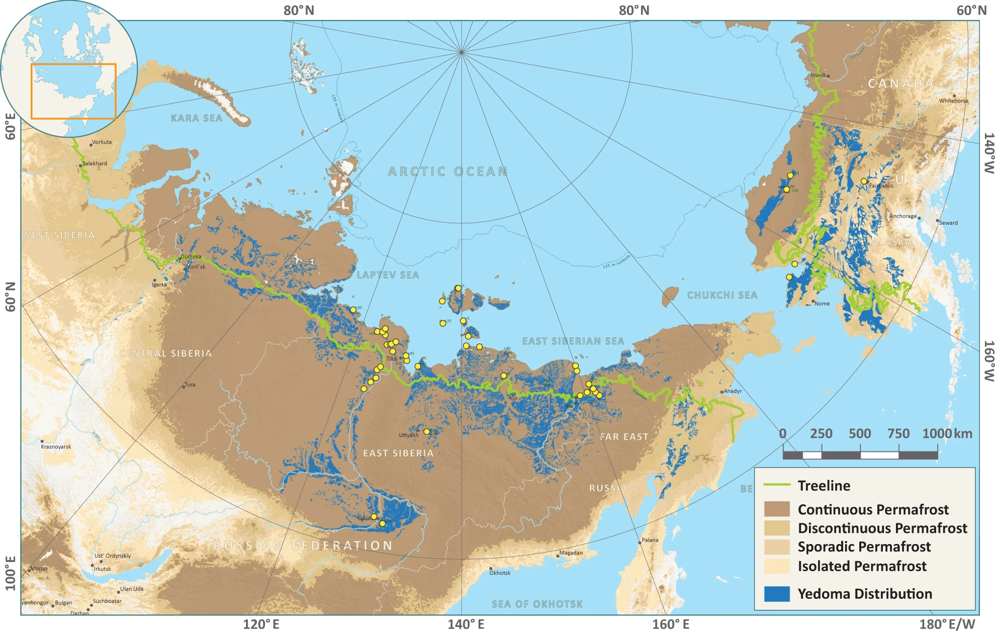
-
Geochemical, lithological, and geochronological characteristics of sediment samples from Yedoma and thermokarst...
This dataset merges data from the yedoma domain in Northern Siberia (RU) and Alaska (US). It includes numerous fieldwork campaigns, which take place since 1998 . In total 224...
-
Database of Ice-Rich Yedoma Permafrost (IRYP)
We synthesized data on the circum-Arctic and sub-Arctic distribution and thickness of Yedoma for compiling a preliminary circum-polar Yedoma map. For compiling this map, we used...
-
Circumpolar Thermokarst Landscapes, 2015, Circum-Arctic
This data set provides the distribution of thermokarst landscapes in the boreal and tundra ecoregions within the northern circumpolar permafrost zones. This dataset provides an...
-
Quaternary deposits map of Yana-Indigirka and Kolyma lowlands tundra zone, R-55-57, based on Landsat imagery
The Quaternary geology map was created for the Yana-Indigirka (eastern part) and Kolyma lowlands, tundra and partly forest-tundra zones. The map corresponds to the nomenclature...
-
Coastal Retrogressive Thaw Slumps from GeoEye-1, WorldView-2 and Aerial Photographs, 2011, Yukon Coast (CA)
Coastal retrogressive thaw slumps (RTSs) were manually digitized at a 1:2000 scale using ArcMap (ESRI, version 10.3) from high‐resolution satellite images acquired in July (13...
-
Annual dynamics of rapid permafrost disturbances from Landsat and Sentinel-2, 2000-2019, Northeast Siberia (RU)
Permafrost is warming globally which leads to widespread permafrost thaw. Particularly ice-rich permafrost is vulnerable to rapid thaw and erosion, impacting whole landscapes...
-
Database of Ice-Rich Yedoma Permafrost Version 2 (IRYP v2)
Ice-rich permafrost in the circum-Arctic and sub-Arctic, such as late Pleistocene Yedoma, are especially prone to degradation due to climate change or human activity. When...