-
Lake Database from Landsat TM and ETM+,1970s, 2000s, 2013-2014, Western Alaska (US)
This vector data layer covers 6 major lake districts (Baldwin Peninsula, Kobuk Delta, Selawik Lowland, Northern Seward Peninsula, Central Seward Peninsula, and Yukon-Kuskokwim...
-
Lakes from Landsat 2000-2001, Lena Delta, Laptev and East Siberian Sea Region (RU)
This data set provides a detailed inventory of lakes in the Lena Delta, northern Siberia, with respect to the lakes' association with one of the three geomorphological main...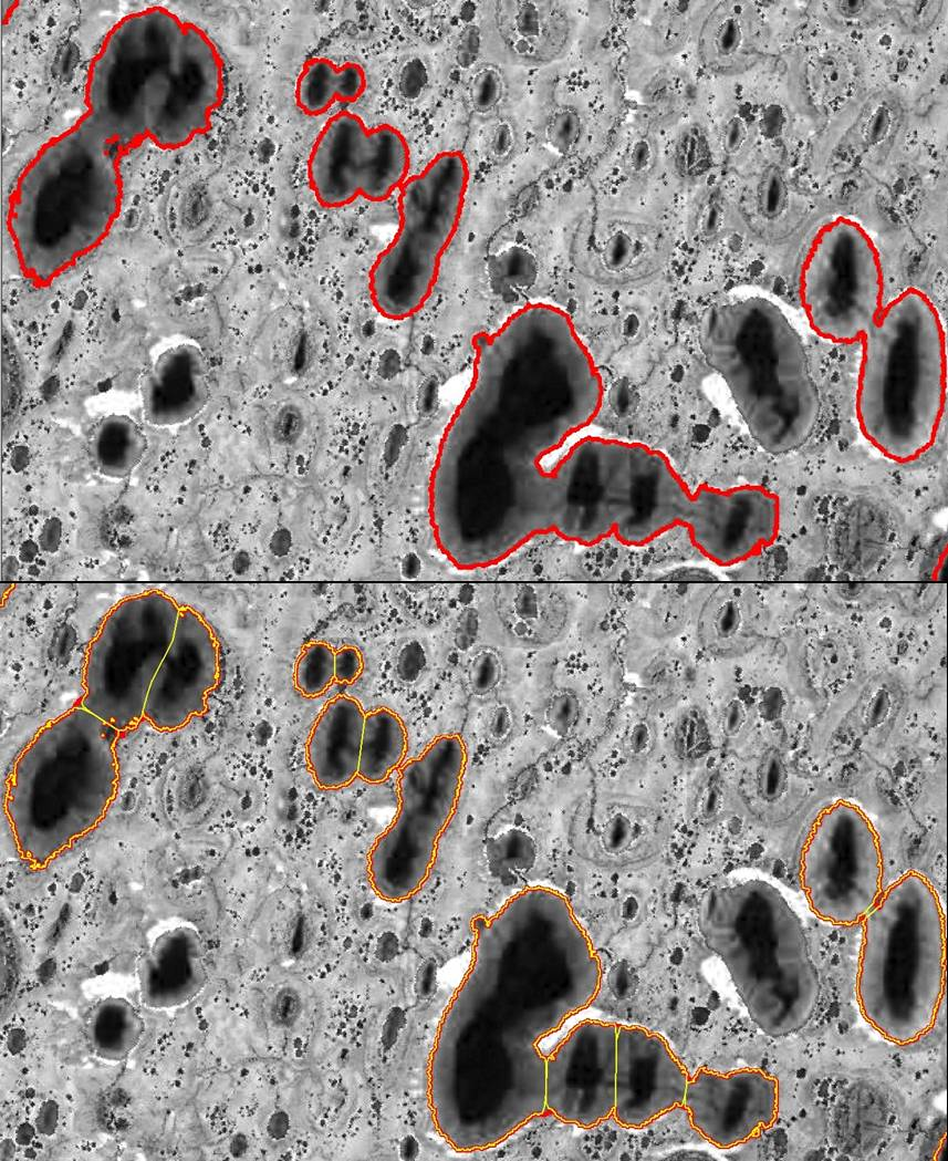
-
Trend analysis of lake dynamics from Landsat time-series 1999-2014, Alaska North Slope, Alaska (US)
The dataset was created with a methodology based on machine-learning based classification of robust trends of multi-spectral indices of Landsat data (TM,ETM+, OLI) and object-...
-
Trend analysis of lake dynamics from Landsat time-series 1999-2014, Kolyma Lowland, Siberia (RU)
The dataset was created with a methodology based on machine-learning based classification of robust trends of multi-spectral indices of Landsat data (TM,ETM+, OLI) and object-...
-
Trend analysis of lake dynamics from Landsat time-series 1999-2014, Central Yakutia, Siberia (RU)
The dataset was created with a methodology based on machine-learning based classification of robust trends of multi-spectral indices of Landsat data (TM,ETM+, OLI) and object-...
-
Trend analysis of lake dynamics from Landsat time-series 1999-2014, Kobuk-Selawik-Lowlands, Alaska (US)
The dataset was created with a methodology based on machine-learning based classification of robust trends of multi-spectral indices of Landsat data (TM,ETM+, OLI) and object-...
-
Coastal Retrogressive Thaw Slumps from GeoEye-1, WorldView-2 and Aerial Photographs, 2011, Yukon Coast (CA)
Coastal retrogressive thaw slumps (RTSs) were manually digitized at a 1:2000 scale using ArcMap (ESRI, version 10.3) from high‐resolution satellite images acquired in July (13...
-
Remote sensing-based permafrost region disturbances: lakes, 1999-2014, Eastern Canada (CA)
The data quantify the abundance and distribution of the permafrost region disturbance (PRD) of lakes and their dynamics, using trend analyses of 30-m-resolution Landsat imagery...
-
Remote sensing-based permafrost region disturbances: fire, 1999-2015, Eastern Canada (CA)
The data quantify the abundance and distribution of the permafrost region disturbance (PRD) wildfire, using trend analyses of 30-m-resolution Landsat imagery from 1999-2015 and...
-
Remote sensing-based permafrost region disturbances: retrogressive thaw slumps, 1999-2014, Alaska (US)
The data quantify the abundance and distribution of the permafrost region disturbance (PRD) of retrogressive thaw slumps, using trend analyses of 30-m-resolution Landsat imagery...
-
Remote sensing-based permafrost region disturbances: lakes, 1999-2014, Alaska (US)
The data quantify the abundance and distribution of the permafrost region disturbance (PRD) of lakes and their dynamics, using trend analyses of 30-m-resolution Landsat imagery...
-
Remote sensing-based permafrost region disturbances: fire, 1999-2015, Alaska (US)
The data quantify the abundance and distribution of the permafrost region disturbance (PRD) wildfire, using trend analyses of 30-m-resolution Landsat imagery from 1999-2015 and...
-
Remote sensing-based permafrost region disturbances: fire, 1999-2015, Eastern Siberia (RU)
The data quantify the abundance and distribution of the permafrost region disturbance (PRD) wildfire, using trend analyses of 30-m-resolution Landsat imagery from 1999-2015 and...
-
Remote sensing-based permafrost region disturbances: lakes, 1999-2014, Eastern Siberia (RU)
The data quantify the abundance and distribution of the permafrost region disturbance (PRD) of lakes and their dynamics, using trend analyses of 30-m-resolution Landsat imagery...
-
Remote sensing-based permafrost region disturbances: retrogressive thaw slumps, 1999-2014, Eastern Siberia (RU)
The data quantify the abundance and distribution of the permafrost region disturbance (PRD) of retrogressive thaw slumps, using trend analyses of 30-m-resolution Landsat imagery...
-
Remote sensing-based permafrost region disturbances: fire, 1999-2015, Western Siberia (RU)
The data quantify the abundance and distribution of the permafrost region disturbance (PRD) wildfire, using trend analyses of 30-m-resolution Landsat imagery from 1999-2015 and...
-
Remote sensing-based permafrost region disturbances: lakes, 1999-2014, Western Siberia (RU)
The data quantify the abundance and distribution of the permafrost region disturbance (PRD) of lakes and their dynamics, using trend analyses of 30-m-resolution Landsat imagery...
-
Remote sensing-based permafrost region disturbances: retrogressive thaw slumps, 1999-2014, Western Siberia (RU)
The data quantify the abundance and distribution of the permafrost region disturbance (PRD) of retrogressive thaw slumps, using trend analyses of 30-m-resolution Landsat imagery...
-
Satellite Photo Mosaic from Corona-KH4, 1962-06-28, Northern Seward Peninsula, Alaska (US)
This raster dataset is a high-resolution mosaic of 4 Corona-KH4 satellite photos over the northern Seward Peninsula in Northwest Alaska dated to 28 July 1962. The mosaic covers...
-
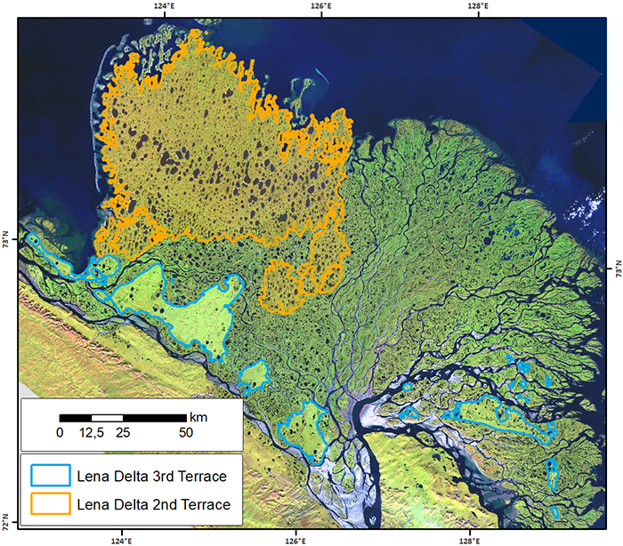
Geomorphological main terraces from Landsat 2000-2001, Lena Delta, Laptev and East Siberian Sea Region (RU)
This data set provides a detailed inventory of lakes in the Lena Delta, northern Siberia, with respect to the lakes' association with one of the three geomorphological main...