-
Polygonal Tundra Geomorphology Map from Landsat time series, 2014, Alaskan Arctic Coastal Plain (US)
We mosaicked twelve LandSat-8 OLI satellite images taken during the summer of 2014, which were used in an object based image analysis (OBIA) to classify the landscape. We mapped...
-
NDVI trend from Landsat time series, 1999-2014, Alaskan Arctic Coastal Plain (US)
Normalized difference vegetation index (NDVI) trend map was computed for the Alaskan Arctic Coastal Plain between 1999 and 2014. The decadal trend of each pixel was computed... -
DARTS: Multi-year database of AI detected retrogressive thaw slumps (RTS) and active layer detachment slides (ALD)...
This dataset, called DARTS, comprises footprints of retrogressive thaw slump (RTS) and active layer detachments slides (ALD) identified and quantified using an automated deep...
-
Field Data on Soils, Vegetation, and Fire History for Alaska Tundra Sites, 1972-2020
This dataset, titled the Synthesized Alaskan Tundra Field Database (SATFiD), provides a comprehensive collection of in-situ field data compiled from 37 existing datasets...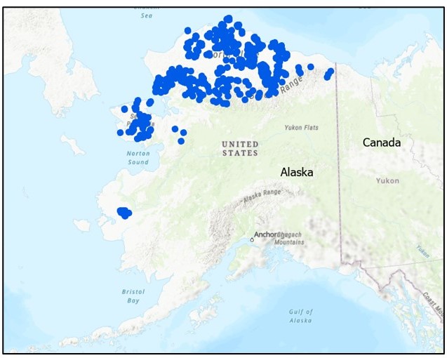
-
Spatial lake dynamics and lake-ice datasets of the Northern Seward and Baldwin Peninsulas in Alaska
The data publication contains supplementary data to the article "Supplementary Dataset to: The catastrophic thermokarst lake drainage events of 2018 in northwestern Alaska:...
-
Total above-ground biomass of 25 sites from 2018 central Lena Delta (RU)
Field investigations were performed in the central Lena Delta. In total, 25 sites were investigated. The sites were chosen to represent a variety of vegetation communities of...
-
Pan-Arctic Visualization of Landscape Change (2003-2022), Arctic PASSION Permafrost Service
This raster dataset, in Cloud Optimized GeoTIFF format (COG), provides information on land surface changes at the pan-arctic scale. Multispectral Landsat-5 TM, Landsat-7 ETM+,...
-
Ground layer above-ground biomass of 39 sites from 2018 central Chukotka (RU) - Raw data of dry weight for each...
Field investigations were performed in four areas: a treeless mountainous tundra (16-KP-04; Lake Rauchuagytgyn area), tundra-taiga transition zone (16-KP-01, Lake Ilirney area)...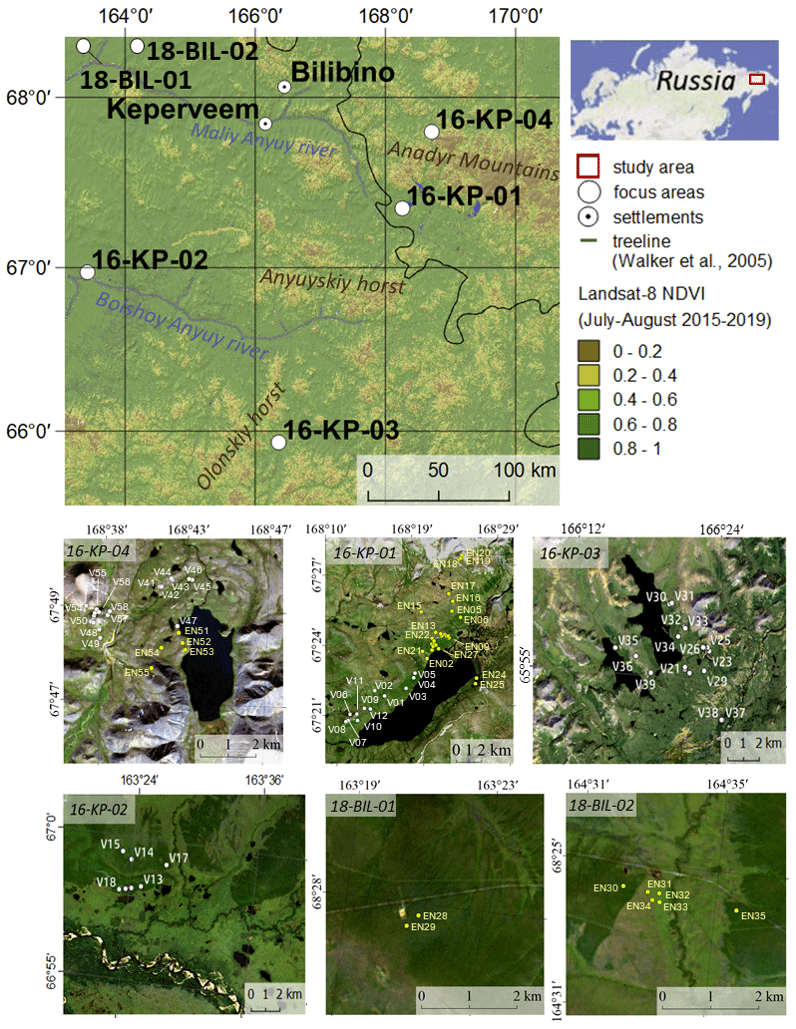
-
Ground layer above-ground biomass of 25 sites from 2018 central Lena Delta (RU) - Raw data of dry weight for each...
Field investigations were performed in the central Lena Delta. In total, 25 sites were investigated. The sites were chosen to represent a variety of vegetation communities of...
-
PEATMAP - peatland distribution maps based on meta-analysis, 1999-2010, Global
PEATMAP is a GIS shapefile dataset that shows a distribution of peatlands that covers the entire world. It was produced by combining the most high quality available peatland map...
-
Global 0.5-deg Wetland Methane Emissions and Uncertainty (WetCHARTs v1.0), 2009-2010
This data set provides global monthly wetland methane (CH4) emissions and uncertainty data products derived from an ensemble of multiple terrestrial biosphere models, wetland...
-
Wetland maps including open water extent dynamics based on ENVISAT ASAR WS for Siberia, 2007 and 2008
Wetlands store large amounts of carbon, and depending on their status and type, they release specific amounts of methane gas to the atmosphere. The connection between wetland...
-
The fractional land cover estimates from the Boreal–Arctic Wetland and Lake Dataset (BAWLD), 2021, Circum-Arctic
The Boreal and Arctic Wetland and Lake Dataset (BAWLD) provides estimates of fractional land cover of 19 land cover classes within 0.5° ×0.5° grid cells. The total area of the...
-
Hyperspectral Imagery AVIRIS-NG V2, 2017-2019, Alaskan and Canadian Arctic
This dataset provides Level 1 radiance and Level 2 surface reflectance measured by the Airborne Visible/Infrared Imaging Spectrometer-Next Generation (AVIRIS-NG) instrument...
-
Circumarctic wetland dataset based on ENVISAT ASAR Global Monitoring Mode, 2005-2011, Panarctic
A circumpolar representative and consistent wetland map is required for a range of applications ranging from upscaling of carbon fluxes and pools to climate modelling and...
-
Vegetation map of Trail Valley Creek from airborne orthophotos, laser scanning and field work data, Northwest...
The vegetation map distinguishes between five tundra vegetation types, trees, and open water at the forest-tundra transition north of Inuvik, Northwest Territories, Canada. The...
-
A high spatial resolution soil carbon and nitrogen dataset for the northern permafrost region
This spatial dataset is quantifying soil organic carbon (SOC) and total nitrogen (TN) storage with their carbon to nitrogen ratio (C/N) in soils of the northern circumpolar...
-
Raster Circumpolar Arctic Vegetation Map (CAVM) from AVHRR, MODIS and elevation data
Land cover maps are the basic data layer required for understanding and modeling ecological patterns and processes. The Circumpolar Arctic Vegetation Map (CAVM), produced in...
-
Monthly global dataset of Wetland Area and Dynamics for Methane Modeling (WAD2M) from Remote Sensing, 2000-2020
Seasonal and interannual variations in global wetland area is a strong driver of fluctuations in global methane (CH4) emissions. Current maps of global wetland extent vary with...
-
Lake-DOC Database (PeRL-DOCv1), 1979-2017, Permafrost-Region
The pan-Arctic Permafrost-Region Lake-DOC version1 database contains surface water samples of lakes in the permafrost regions of Alaska (49.3 %), Canada (24.2 %), Greenland (3.2...