-
Spatial lake dynamics and lake-ice datasets of the Northern Seward and Baldwin Peninsulas in Alaska
The data publication contains supplementary data to the article "Supplementary Dataset to: The catastrophic thermokarst lake drainage events of 2018 in northwestern Alaska:...
-
Total above-ground biomass of 25 sites from 2018 central Lena Delta (RU)
Field investigations were performed in the central Lena Delta. In total, 25 sites were investigated. The sites were chosen to represent a variety of vegetation communities of...
-
Pan-Arctic Visualization of Landscape Change (2003-2022), Arctic PASSION Permafrost Service
This raster dataset, in Cloud Optimized GeoTIFF format (COG), provides information on land surface changes at the pan-arctic scale. Multispectral Landsat-5 TM, Landsat-7 ETM+,...
-
Quaternary deposits map of Yana-Indigirka and Kolyma lowlands tundra zone, R-55-57, based on Landsat imagery
The Quaternary geology map was created for the Yana-Indigirka (eastern part) and Kolyma lowlands, tundra and partly forest-tundra zones. The map corresponds to the nomenclature...
-
Database of Ice-Rich Yedoma Permafrost (IRYP)
We synthesized data on the circum-Arctic and sub-Arctic distribution and thickness of Yedoma for compiling a preliminary circum-polar Yedoma map. For compiling this map, we used...
-
Anaerobic incubation measurements (CH4+CO2) and microbe quantification, Lena Delta, 2018
The data sets were made during the summer 2021, with samples collected from three cores, at two depths (active and permafrost layers). In total, six samples (3 replicates by...
-
Surface Soil Moisture from ENVISAT ASAR GM, 2005-2010, Laptev Sea Coast, Laptev and East Siberian Sea Region (RU)
The SAR Surface Soil Moisture (SSM) product is derived from the ENVISAT ASAR sensor operating in Global Monitoring (GM) mode. The SAR SSM product is a weekly mean composite at 1...
-
Surface Soil Moisture from ENVISAT ASAR GM, 2005-2011, Mackenzie River Valley and Delta, Beaufort Sea Region (CA)
The SAR Surface Soil Moisture (SSM) product is derived from the ENVISAT ASAR sensor operating in Global Monitoring (GM) mode. The SAR SSM product is a weekly mean composite at 1...
-
Surface Soil Moisture from ENVISAT ASAR GM, 2005-2011, Ob Estuary and Yamal Peninsula, Western Siberia (RU)
The SAR Surface Soil Moisture (SSM) product is derived from the ENVISAT ASAR sensor operating in Global Monitoring (GM) mode. The SAR SSM product is a weekly mean composite at 1...
-
Water Body Classification from ENVISAT ASAR Wide Swath, 2007-2011, Lena Delta / East Taymir / Cherskii, Laptev and Ea...
The regional waterbody classification is derived from ENVISAT ASAR Wide Swath data with 150 m resolution. Maps represent the extent of water bodies for the summer months July...
-
Water Body Classification from ENVISAT ASAR Wide Swath, 2007-2011, Ob Estuary and Yamal Peninsula, Western Siberia (RU)
The regional waterbody classification is derived from ENVISAT ASAR Wide Swath data with 150 m resolution. Maps represent the extent of water bodies for the summer months July...
-
Surface Soil Moisture from ENVISAT ASAR GM, 2005-2011, Yakutsk, Central Yakutia (RU)
The SAR Surface Soil Moisture (SSM) product is derived from the ENVISAT ASAR sensor operating in Global Monitoring (GM) mode. The SAR SSM product is a weekly mean composite at 1...
-
Water Body Classification from ENVISAT ASAR Wide Swath, 2007-2008, Yakutsk, Central Yakutia (RU)
The regional waterbody classification is derived from ENVISAT ASAR Wide Swath data with 150 m resolution. Maps represent the extent of water bodies for the summer months July...
-
Water Body Classification from ENVISAT ASAR Wide Swath, 2007-2011, Mackenzie River Valley and Delta, Beaufort Sea Reg...
The regional waterbody classification is derived from ENVISAT ASAR Wide Swath data with 150 m resolution. Maps represent the extent of water bodies for the summer months July...
-
T-MOSAiC 2021 myThaw data set, Circum-Arctic
The Terrestrial Multidisciplinary distributed Observatories for the Study of the Arctic Connections (T-MOSAiC) 2021 permafrost thaw data set provides standardized measurements...
-
Pingo Database, 2022, Svalbard (NO)
The data contains the list of pingo and pingo-like forms over Svalbard archipelago. Each pingo is assigned with following data: coordinates, absolute height of pingo baseline,...
-
Inorganic and organic hydrochemistry of lakes and ponds in continuous permafrost landscapes in the western Canadian A...
Between 2006 and 2015 inorganic and organic hydrochemical parameters and stable water isotope characteristics were measured in lakes and ponds in continuous permafrost...
-
Ground layer above-ground biomass of 39 sites from 2018 central Chukotka (RU) - Raw data of dry weight for each sub-g...
Field investigations were performed in four areas: a treeless mountainous tundra (16-KP-04; Lake Rauchuagytgyn area), tundra-taiga transition zone (16-KP-01, Lake Ilirney area)...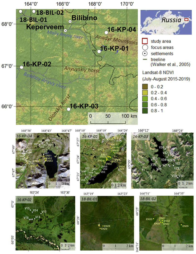
-
Ground layer above-ground biomass of 25 sites from 2018 central Lena Delta (RU) - Raw data of dry weight for each sub...
Field investigations were performed in the central Lena Delta. In total, 25 sites were investigated. The sites were chosen to represent a variety of vegetation communities of...
-
Remote sensing reflectance (Rrs) of the surface water during 4 expeditions from spring to fall in 2019, Mackenzie Del...
Vertical profiles of downwelling irradiance (Ed) and upwelling radiance (Lu) were measured during legs 2, 3, and 4 using a Compact-Optical Profiling System (C-OPS) in an ICE-Pro...
