-
CARVE atmospheric gas concentrations, airborne flasks, Alaska, 2012-2015
This dataset provides atmospheric carbon dioxide (CO2), methane (CH4), carbon monoxide (CO), molecular hydrogen (H2), nitrous oxide (N2O), sulfur hexafluoride (SF6), and other...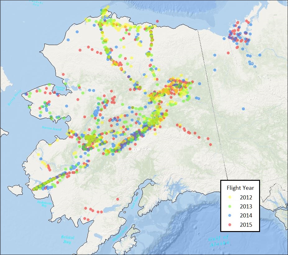
-
CARVE atmospheric gas concentrations, airborne spectrometer, Alaska, 2012-2015
This data set provides atmospheric carbon dioxide (CO2), methane (CH4), carbon monoxide (CO), ozone (O3), and water vapor (H2O) concentrations from airborne campaigns over the...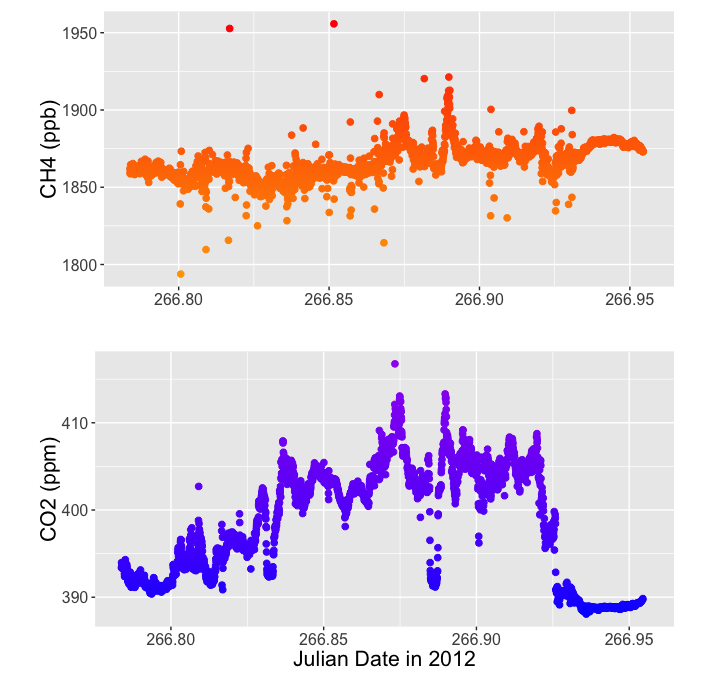
-
Dataset of a globally relevant stock of soil nitrogen in the Yedoma permafrost domain, 1998-2016, Circum-Arctic
This dataset merges nitrogen data from the Yedoma domain. It includes numerous fieldwork campaigns, which take place since 1998. In total 467 samples from the active layer...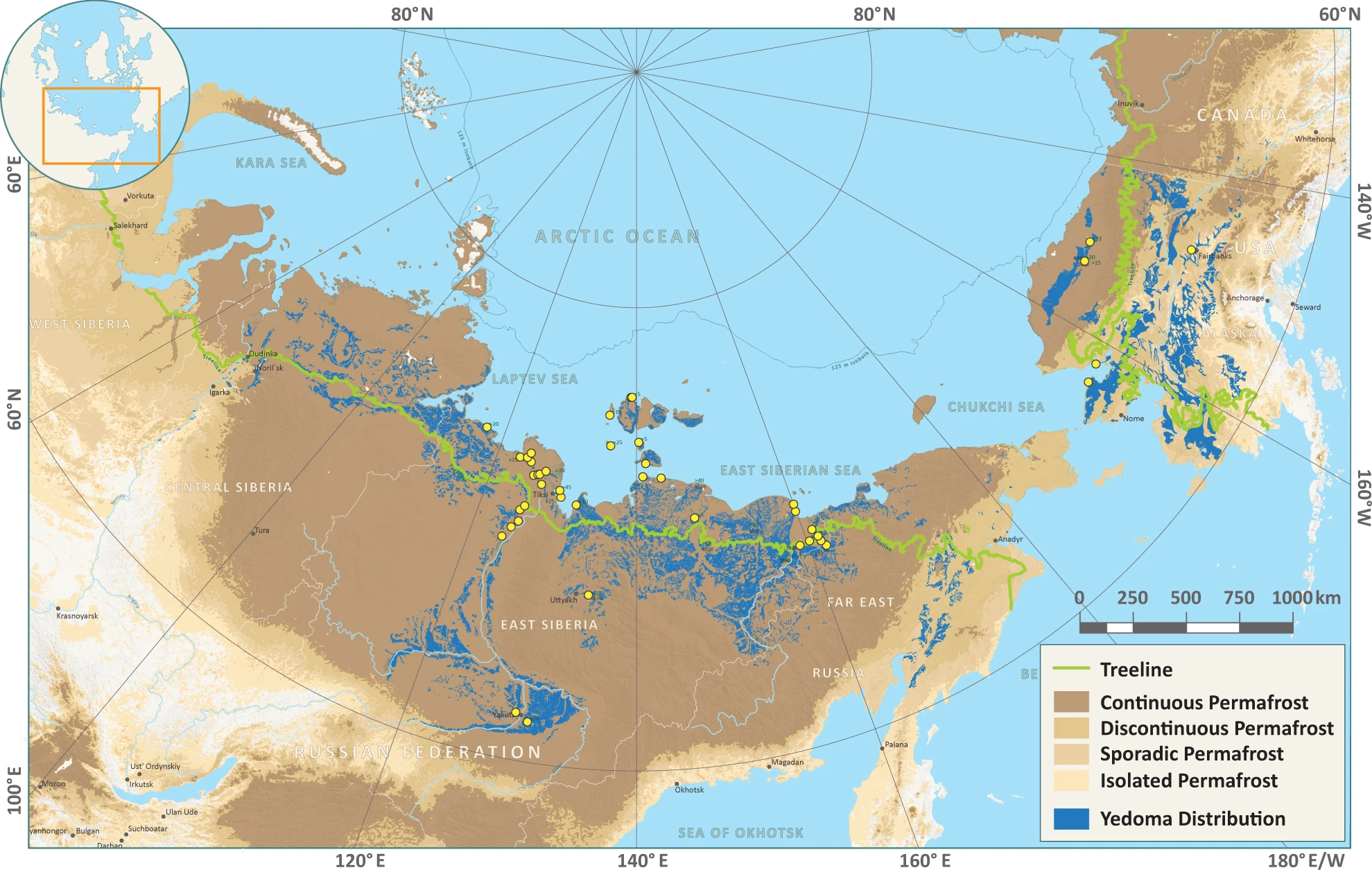
-
Methane flux from closed chamber with spectrometer across two thermokarst lake ecosystems, 2018, Interior Alaska (US)
This dataset provides diffusive methane (CH4) fluxes collected from two thermokarst lakes in the Goldstream Valley, north of Fairbanks in interior Alaska. Fluxes were collected...
-
Methane Fluxes from Shorelines and Differing Surfaces, 2019, Big Trail Lake, Alaska (US)
This dataset provides methane fluxes from hot-spot and non-hot spot differing surfaces at Big Trail Lake (BTL) in the Goldstream Valley near Fairbanks, AK, USA. Measurements...
-
Detailed pedon data on soil carbon and nitrogen for the northern permafrost region
Soils in the northern high latitudes are a key component in the global carbon cycle; the northern permafrost region covers 22% of the Northern Hemisphere and holds almost twice...
-
A high spatial resolution soil carbon and nitrogen dataset for the northern permafrost region
This spatial dataset is quantifying soil organic carbon (SOC) and total nitrogen (TN) storage with their carbon to nitrogen ratio (C/N) in soils of the northern circumpolar...
-
Global methane data from 2002 to present derived from satellite observations
This dataset provides observations of atmospheric methane (CH4) amounts obtained from observations collected by several current and historical satellite instruments. Methane is...
-
Monthly global dataset of Wetland Area and Dynamics for Methane Modeling (WAD2M) from Remote Sensing, 2000-2020
Seasonal and interannual variations in global wetland area is a strong driver of fluctuations in global methane (CH4) emissions. Current maps of global wetland extent vary with...
-
Lake-DOC Database (PeRL-DOCv1), 1979-2017, Permafrost-Region
The pan-Arctic Permafrost-Region Lake-DOC version1 database contains surface water samples of lakes in the permafrost regions of Alaska (49.3 %), Canada (24.2 %), Greenland (3.2...
-
Database of Global Peatland Extent and Carbon Stocks through the Last Glacial Cycle (130 ka to present)
We present the first synthesis of global peatland extent through the last glacial cycle (130 ka) based on >975 detailed stratigraphic descriptions from exposures, soil pits,...
-
Database of Ice-Rich Yedoma Permafrost Version 2 (IRYP v2)
Ice-rich permafrost in the circum-Arctic and sub-Arctic, such as late Pleistocene Yedoma, are especially prone to degradation due to climate change or human activity. When...
-
Database of Quaternary Deposits from Maps, East and Central Siberia (RU)
This digital database is the product of collaboration between the U.S. Geological Survey, the Alfred Wegener Institute for Polar and Marine Research Potsdam, Foothill College...
-
Geochemical, lithological, and geochronological characteristics of sediment samples from Yedoma and thermokarst...
This dataset merges data from the yedoma domain in Northern Siberia (RU) and Alaska (US). It includes numerous fieldwork campaigns, which take place since 1998 . In total 224...
-
Remote sensing-based permafrost region disturbances: lakes, 1999-2014, Eastern Canada (CA)
The data quantify the abundance and distribution of the permafrost region disturbance (PRD) of lakes and their dynamics, using trend analyses of 30-m-resolution Landsat imagery...
-
Remote sensing-based permafrost region disturbances: lakes, 1999-2014, Alaska (US)
The data quantify the abundance and distribution of the permafrost region disturbance (PRD) of lakes and their dynamics, using trend analyses of 30-m-resolution Landsat imagery...
-
Remote sensing-based permafrost region disturbances: lakes, 1999-2014, Eastern Siberia (RU)
The data quantify the abundance and distribution of the permafrost region disturbance (PRD) of lakes and their dynamics, using trend analyses of 30-m-resolution Landsat imagery...
-
Remote sensing-based permafrost region disturbances: lakes, 1999-2014, Western Siberia (RU)
The data quantify the abundance and distribution of the permafrost region disturbance (PRD) of lakes and their dynamics, using trend analyses of 30-m-resolution Landsat imagery...
-
Growing season, non-growing season and annual CH4 fluxes from temperate, boreal, and Arctic wetlands and uplands,...
Wetlands are the single largest natural source of atmospheric methane (CH4), a greenhouse gas, and occur extensively in the northern hemisphere. Large discrepancies remain...
-
Cumulative greenhouse gas production in thawed sediments, 2019-2020, Yukechi Alas, Central Yakutia (RU)
This dataset describes two 17 m long sediment cores taken from beneath two thermokarst lakes in the Yukechi Alas, Central Yakutia, Russia. The first core was taken from below an...