-
Monthly global dataset of Wetland Area and Dynamics for Methane Modeling (WAD2M) from Remote Sensing, 2000-2020
Seasonal and interannual variations in global wetland area is a strong driver of fluctuations in global methane (CH4) emissions. Current maps of global wetland extent vary with...
-
Lake-DOC Database (PeRL-DOCv1), 1979-2017, Permafrost-Region
The pan-Arctic Permafrost-Region Lake-DOC version1 database contains surface water samples of lakes in the permafrost regions of Alaska (49.3 %), Canada (24.2 %), Greenland (3.2...
-
Database of Ice-Rich Yedoma Permafrost Version 2 (IRYP v2)
Ice-rich permafrost in the circum-Arctic and sub-Arctic, such as late Pleistocene Yedoma, are especially prone to degradation due to climate change or human activity. When...
-
Mapped thermokarst ice wedge polygon patterns from WorldView-1, 2009, Ebe-Basyn-Sise Island, SW Lena Delta, Siberia (RU)
Detailed calculations of ground-ice volumes in permafrost deposits are necessary to understand and quantify the response of permafrost landscapes to thermal disturbance and...
-
Ground ice maps from paleogeographic modelling approach, Canada (CA)
Ground ice melt caused by climate-induced permafrost degradation may trigger significant ecological change, damage infrastructure, and alter biogeochemical cycles. The...
-
Circumpolar raster grids of permafrost extent and geohazard potential for near-future climate scenarios
One of the consequences of warming climate is rising ground temperatures and degradation of perennially frozen ground, permafrost. Thawing of near-surface permafrost can cause...
-
Remotely-sensed Arctic Discharge Reanalysis (RADR) from discharge observations and Landsat, 1984-2018, Circum-Arctic
Arctic rivers drain ~15% of the global land surface and significantly influence local communities and economies, freshwater and marine ecosystems, and global climate. However,...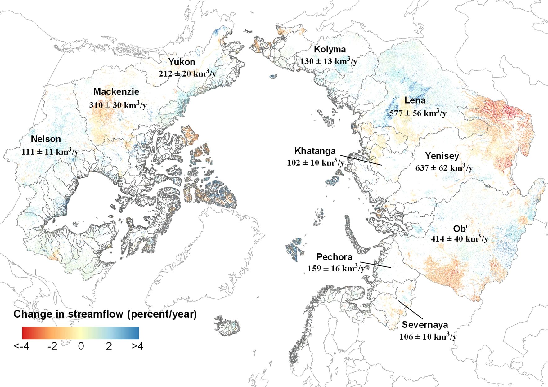
-
Quantification of shoreline movements from satellite remote sensing, 1951-2011, Yukon Territory mainland coast (CA)
The Arctic is warming, but the impacts on its coasts are not well documented. To better understand the reaction of Arctic coasts to increasing environmental pressure, shoreline...
-
Permafrost active layer thickness for the Northern Hemisphere, v3.0 from MODIS LST, ERA5, 1997-2019
This dataset contains permafrost active layer thickness data produced as part of the European Space Agency's (ESA) Climate Change Initiative (CCI) Permafrost project. It forms...
-
Annual dynamics of rapid permafrost disturbances from Landsat and Sentinel-2, 2000-2019, Northeast Siberia (RU)
Permafrost is warming globally which leads to widespread permafrost thaw. Particularly ice-rich permafrost is vulnerable to rapid thaw and erosion, impacting whole landscapes...
-
Mapped yedoma ice wedge polygon patterns from WorldView-1, 2009, Ebe-Basyn-Sise Island, SW Lena Delta, Siberia (RU)
Detailed calculations of ground-ice volumes in permafrost deposits are necessary to understand and quantify the response of permafrost landscapes to thermal disturbance and...
-
Mapped polygon pattern geomorphometry from HRSC-AX, 2009, Act-IWS Adventdalen, Svalbard (NO)
Polygonal systems formed by thermal contraction cracking are complex landscape features widespread in terrestrial periglacial regions. The manner in which cracking occurs is...
-
Recovered Drained Thaw Lake Basins (DTLBs) from InSAR DEM and Remote Sensing Imagery, 2002-2010, Arctic Coastal...
Paleoshorelines of Drained Thaw Lake Basins (DTLBs) on the Alaskan North Slope were mapped using the Interferometric Synthetic Aperture Radar Digital Elevation Model (InSAR DEM)...
-
Growing season, non-growing season and annual CH4 fluxes from temperate, boreal, and Arctic wetlands and uplands,...
Wetlands are the single largest natural source of atmospheric methane (CH4), a greenhouse gas, and occur extensively in the northern hemisphere. Large discrepancies remain...
-
Cumulative greenhouse gas production in thawed sediments, 2019-2020, Yukechi Alas, Central Yakutia (RU)
This dataset describes two 17 m long sediment cores taken from beneath two thermokarst lakes in the Yukechi Alas, Central Yakutia, Russia. The first core was taken from below an...
-
TCCON data from Ny-Ålesund, Svalbard (NO), Release GGG2020.R0
The Total Carbon Column Observing Network (TCCON) is a network of ground-based Fourier Transform Spectrometers that record direct solar absorption spectra of the atmosphere in... -
In-situ Carbon and CH4 Flux and Meteorology at EC Towers, Atqasuk, Barrow, Ivotuk, Alaska, 2011-2015
This data set provides ground in situ flux and meteorological science data from fixed instruments at three eddy covariance tower sites located in the Alaskan Arctic tundra. Real...
-
Submarine Permafrost Map (SuPerMAP), modeled with CryoGrid 2, Circum-Arctic
This data set contains a first‐order estimate of distribution, thickness and ice-content of submarine permafrost on the Arctic shelf based on a numerical heat transfer model....
-
Lake Basal Ages and Origins from scientific literature, Circum-Arctic
This dataset is a compilation of 1,207 lake basal ages used to identify spatial and temporal patterns of lake formation across the high northern latitudes. Data was gathered...