-
Content of carbon isotopes (¹³C and ¹⁴C) in organic carbon pools in terrestrial Siberia
The dataset consists of one xlsx file with four sheets, listing (1) ¹³C and ¹⁴C data of litter and organic layers in northern Russia, Scandinavia, Canada and Alaska; (2) ¹³C and...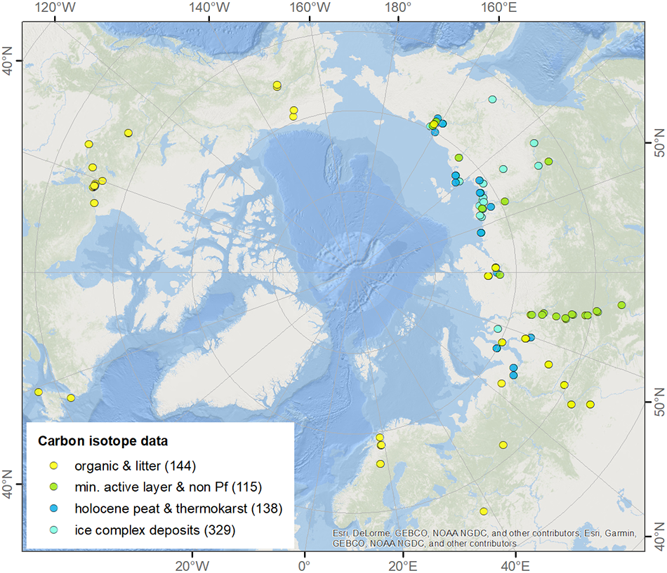
-
NDVI trend from Landsat time series, 1999-2014, Alaskan Arctic Coastal Plain (US)
Normalized difference vegetation index (NDVI) trend map was computed for the Alaskan Arctic Coastal Plain between 1999 and 2014. The decadal trend of each pixel was computed...
-
DARTS: Multi-year database of AI detected retrogressive thaw slumps (RTS) and active layer detachment slides (ALD)...
This dataset, called DARTS, comprises footprints of retrogressive thaw slump (RTS) and active layer detachments slides (ALD) identified and quantified using an automated deep...
-
Pan-Arctic thermokarst lagoon distribution, area and classification from Landsat images, 1984 to 2021
Thermokarst lagoons develop in permafrost lowlands along the ice-rich Arctic coast when thermokarst lakes or basins with bottom elevations at or below sea level are breached by...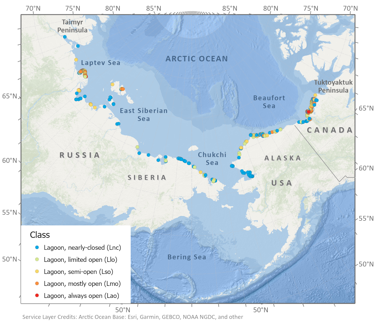
-
Spatial lake dynamics and lake-ice datasets of the Northern Seward and Baldwin Peninsulas in Alaska
The data publication contains supplementary data to the article "Supplementary Dataset to: The catastrophic thermokarst lake drainage events of 2018 in northwestern Alaska:...
-
Pan-Arctic Visualization of Landscape Change (2003-2022), Arctic PASSION Permafrost Service
This raster dataset, in Cloud Optimized GeoTIFF format (COG), provides information on land surface changes at the pan-arctic scale. Multispectral Landsat-5 TM, Landsat-7 ETM+,...
-
Quaternary deposits map of Yana-Indigirka and Kolyma lowlands tundra zone, R-55-57, based on Landsat imagery
The Quaternary geology map was created for the Yana-Indigirka (eastern part) and Kolyma lowlands, tundra and partly forest-tundra zones. The map corresponds to the nomenclature...
-
Database of Ice-Rich Yedoma Permafrost (IRYP)
We synthesized data on the circum-Arctic and sub-Arctic distribution and thickness of Yedoma for compiling a preliminary circum-polar Yedoma map. For compiling this map, we used...
-
Anaerobic incubation measurements (CH4+CO2) and microbe quantification, Lena Delta, 2018
The data sets were made during the summer 2021, with samples collected from three cores, at two depths (active and permafrost layers). In total, six samples (3 replicates by...
-
ABoVE: Methane Ebullition Hotspots in Frozen Lakes near Fairbanks, Alaska, Oct 2014
This dataset includes maps of the locations and number of methane ebullition hotspots in 15 frozen lakes in the southern portion of the Goldstream Valley and the surrounding...
-
Surface Soil Moisture from ENVISAT ASAR GM, 2005-2010, Laptev Sea Coast, Laptev and East Siberian Sea Region (RU)
The SAR Surface Soil Moisture (SSM) product is derived from the ENVISAT ASAR sensor operating in Global Monitoring (GM) mode. The SAR SSM product is a weekly mean composite at 1...
-
Surface Soil Moisture from ENVISAT ASAR GM, 2005-2011, Mackenzie River Valley and Delta, Beaufort Sea Region (CA)
The SAR Surface Soil Moisture (SSM) product is derived from the ENVISAT ASAR sensor operating in Global Monitoring (GM) mode. The SAR SSM product is a weekly mean composite at 1...
-
Surface Soil Moisture from ENVISAT ASAR GM, 2005-2011, Ob Estuary and Yamal Peninsula, Western Siberia (RU)
The SAR Surface Soil Moisture (SSM) product is derived from the ENVISAT ASAR sensor operating in Global Monitoring (GM) mode. The SAR SSM product is a weekly mean composite at 1...
-
Water Body Classification from ENVISAT ASAR Wide Swath, 2007-2011, Lena Delta / East Taymir / Cherskii, Laptev and...
The regional waterbody classification is derived from ENVISAT ASAR Wide Swath data with 150 m resolution. Maps represent the extent of water bodies for the summer months July...
-
Water Body Classification from ENVISAT ASAR Wide Swath, 2007-2011, Ob Estuary and Yamal Peninsula, Western Siberia (RU)
The regional waterbody classification is derived from ENVISAT ASAR Wide Swath data with 150 m resolution. Maps represent the extent of water bodies for the summer months July...
-
Surface Soil Moisture from ENVISAT ASAR GM, 2005-2011, Yakutsk, Central Yakutia (RU)
The SAR Surface Soil Moisture (SSM) product is derived from the ENVISAT ASAR sensor operating in Global Monitoring (GM) mode. The SAR SSM product is a weekly mean composite at 1...
-
Water Body Classification from ENVISAT ASAR Wide Swath, 2007-2008, Yakutsk, Central Yakutia (RU)
The regional waterbody classification is derived from ENVISAT ASAR Wide Swath data with 150 m resolution. Maps represent the extent of water bodies for the summer months July...
-
Water Body Classification from ENVISAT ASAR Wide Swath, 2007-2011, Mackenzie River Valley and Delta, Beaufort Sea Region (CA)
The regional waterbody classification is derived from ENVISAT ASAR Wide Swath data with 150 m resolution. Maps represent the extent of water bodies for the summer months July...
-
Rockglacier and Slope Instability Inventory from differential SAR interferograms and optical imagery, 1998-2016,...
Rockglaciers and other periglacial processes were mapped using visual analysis of differential SAR interferograms and satellite optical images (Google Satellite, Bing Aerial)...
-
Pingo Database, 2022, Svalbard (NO)
The data contains the list of pingo and pingo-like forms over Svalbard archipelago. Each pingo is assigned with following data: coordinates, absolute height of pingo baseline,...