-
Permafrost ground temperature for the Northern Hemisphere, v2.0 from MODIS LST, ERA5, 1997-2018
This dataset contains permafrost ground temperature data produced as part of the European Space Agency's (ESA) Climate Change Initiative (CCI) Permafrost project. It forms part...
-
Permafrost extent for the Northern Hemisphere, v2.0 from MODIS LST, ERA5, 1997-2018
This dataset contains permafrost extent data produced as part of the European Space Agency's (ESA) Climate Change Initiative (CCI) Permafrost project. It forms part of the first...
-
Active layer depth map, 1960-1987, Yakutia, ASSR
The rasterized map of active layer depth of Yakutia, East Siberia, was derived based on the map of landscapes and permafrost conditions in Yakutia (Merzlotno-landshaftnaya karta...
-
Permafrost Extent and Ground Temperature Map, 2000-2016, Northern Hemisphere Permafrost
The product provides modeled mean annual ground temperatures (MAGT) at the top of the permafrost for the Northern Hemisphere at 1 km spatial resolution. Permafrost probability...
-
Submarine Permafrost Map (SuPerMAP), modeled with CryoGrid 2, Circum-Arctic
This data set contains a first‐order estimate of distribution, thickness and ice-content of submarine permafrost on the Arctic shelf based on a numerical heat transfer model....
-
Ground Temperature Map, 2000-2017, Antarctic
The product provides modeled mean annual ground temperatures (MAGT) at the top of the permafrost for Antarctica and Subantarctic islands at 1 km spatial resolution. Permafrost...
-
Ground Temperature Map, 2000-2016, Andes
The product provides modeled mean annual ground temperatures (MAGT) at the top of the permafrost for Andes at 1 km spatial resolution. Permafrost probability (fraction values...
-
Ground Temperature Map, 2000-2016, East African Plateau
The product provides modeled mean annual ground temperatures (MAGT) at the top of the permafrost for the East African Plateau at 1 km spatial resolution. Permafrost probability...
-
Permafrost Temperature Data on GTN-P
This is a preliminary link to permafrost temperature data on GTN-P. It will be replaced in future by more detailed dataset descriptions. Permafrost temperature data from...
-
Frozen State Backscatter Intensity from Sentinel-1, 2015-2016, West Siberia (RU)
Frozen state backscatter intensity was derived from Sentinel-1 acquisitions from December 2015 and 2016. By excluding the effects of liquid water content (acquisitions under...
-
Frozen State Backscatter Intensity from Sentinel-1, 2015-2016, Usa Basin, European Russia (RU)
Frozen state backscatter intensity was derived from Sentinel-1 acquisitions from December 2015 and 2016. By excluding the effects of liquid water content (acquisitions under...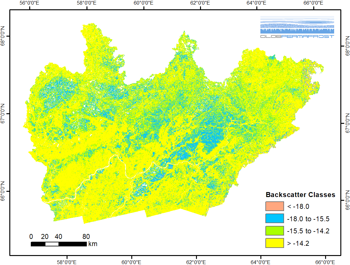
-
Frozen State Backscatter Intensity from Sentinel-1, 2015-2016, Teshekpuk, Alaska (US)
Frozen state backscatter intensity was derived from Sentinel-1 acquisitions from December 2015 and 2016. By excluding the effects of liquid water content (acquisitions under...
-
Frozen State Backscatter Intensity from Sentinel-1, 2015-2016, Toolik, Alaska (US)
Frozen state backscatter intensity was derived from Sentinel-1 acquisitions from December 2015 and 2016. By excluding the effects of liquid water content (acquisitions under...
-
Frozen State Backscatter Intensity from Sentinel-1, 2015-2016, Barrow, Alaska (US)
Frozen state backscatter intensity was derived from Sentinel-1 acquisitions from December 2015 and 2016. By excluding the effects of liquid water content (acquisitions under...
-
Frozen State Backscatter Intensity from Sentinel-1, 2014-2016, Lena Delta, Laptev and East Siberian Sea Region (RU)
Frozen state backscatter intensity was derived from Sentinel-1 acquisitions from December 2015 and 2016. By excluding the effects of liquid water content (acquisitions under...
-
Lake Basal Ages and Origins from scientific literature, Circum-Arctic
This dataset is a compilation of 1,207 lake basal ages used to identify spatial and temporal patterns of lake formation across the high northern latitudes. Data was gathered...
-
Freeze/Thaw Timing from ENVISAT ASAR GM, 2005-2010, Ob Estuary and Yamal Peninsula, Western Siberia (RU)
The SAR Freeze/Thaw product indicates the timing (day of year) of ground surface freeze-up and thawing at a resolution of 1 km. It is derived from the ENVISAT ASAR sensor...
-
Freeze/Thaw Timing from ENVISAT ASAR GM, 2005-2010, Yakutsk, Central Yakutia (RU)
The SAR Freeze/Thaw product indicates the timing (day of year) of ground surface freeze-up and thawing at a resolution of 1 km. It is derived from the ENVISAT ASAR sensor...
-
Freeze/Thaw Timing from ENVISAT ASAR GM, 2005-2010, Laptev Sea Coast, Laptev and East Siberian Sea Region (RU)
The SAR Freeze/Thaw product indicates the timing (day of year) of ground surface freeze-up and thawing at a resolution of 1 km. It is derived from the ENVISAT ASAR sensor...
-
Freeze/Thaw Timing from ENVISAT ASAR GM, 2005-2010, Mackenzie River Valley and Delta, Beaufort Sea Region (CA)
The SAR Freeze/Thaw product indicates the timing (day of year) of ground surface freeze-up and thawing at a resolution of 1 km. It is derived from the ENVISAT ASAR sensor...