-
Dataset for Assessing volumetric change distributions and scaling relations of thaw slumps across the Arctic
Arctic ice-rich permafrost is becoming increasingly vulnerable to terrain-altering thermokarst, and among the most rapid and dramatic of these changes are retrogressive thaw... -
Coastal Retrogressive Thaw Slumps from GeoEye-1, WorldView-2 and Aerial Photographs, 2011, Yukon Coast (CA)
Coastal retrogressive thaw slumps (RTSs) were manually digitized at a 1:2000 scale using ArcMap (ESRI, version 10.3) from high‐resolution satellite images acquired in July (13... -
Remote sensing-based permafrost region disturbances: lakes, 1999-2014, Eastern Canada (CA)
The data quantify the abundance and distribution of the permafrost region disturbance (PRD) of lakes and their dynamics, using trend analyses of 30-m-resolution Landsat imagery... -
Remote sensing-based permafrost region disturbances: fire, 1999-2015, Eastern Canada (CA)
The data quantify the abundance and distribution of the permafrost region disturbance (PRD) wildfire, using trend analyses of 30-m-resolution Landsat imagery from 1999-2015 and... -
Remote sensing-based permafrost region disturbances: retrogressive thaw slumps, 1999-2014, Alaska (US)
The data quantify the abundance and distribution of the permafrost region disturbance (PRD) of retrogressive thaw slumps, using trend analyses of 30-m-resolution Landsat imagery... -
Remote sensing-based permafrost region disturbances: lakes, 1999-2014, Alaska (US)
The data quantify the abundance and distribution of the permafrost region disturbance (PRD) of lakes and their dynamics, using trend analyses of 30-m-resolution Landsat imagery... -
Remote sensing-based permafrost region disturbances: fire, 1999-2015, Alaska (US)
The data quantify the abundance and distribution of the permafrost region disturbance (PRD) wildfire, using trend analyses of 30-m-resolution Landsat imagery from 1999-2015 and... -
Remote sensing-based permafrost region disturbances: fire, 1999-2015, Eastern Siberia (RU)
The data quantify the abundance and distribution of the permafrost region disturbance (PRD) wildfire, using trend analyses of 30-m-resolution Landsat imagery from 1999-2015 and... -
Remote sensing-based permafrost region disturbances: lakes, 1999-2014, Eastern Siberia (RU)
The data quantify the abundance and distribution of the permafrost region disturbance (PRD) of lakes and their dynamics, using trend analyses of 30-m-resolution Landsat imagery... -
Remote sensing-based permafrost region disturbances: retrogressive thaw slumps, 1999-2014, Eastern Siberia (RU)
The data quantify the abundance and distribution of the permafrost region disturbance (PRD) of retrogressive thaw slumps, using trend analyses of 30-m-resolution Landsat imagery... -
Remote sensing-based permafrost region disturbances: fire, 1999-2015, Western Siberia (RU)
The data quantify the abundance and distribution of the permafrost region disturbance (PRD) wildfire, using trend analyses of 30-m-resolution Landsat imagery from 1999-2015 and... -
Remote sensing-based permafrost region disturbances: lakes, 1999-2014, Western Siberia (RU)
The data quantify the abundance and distribution of the permafrost region disturbance (PRD) of lakes and their dynamics, using trend analyses of 30-m-resolution Landsat imagery... -
Remote sensing-based permafrost region disturbances: retrogressive thaw slumps, 1999-2014, Western Siberia (RU)
The data quantify the abundance and distribution of the permafrost region disturbance (PRD) of retrogressive thaw slumps, using trend analyses of 30-m-resolution Landsat imagery... -
Beaver Dam Locations from sub-meter resolution Satellite Imagery, 2010-2019, Northern Baldwin Peninsula Alaska (US)
Arctic landscapes are in a state of transition due to changes in climate occurring during both the summer and winter seasons. Scattered observations indicate that beavers... -
Beaver Dam Locations from sub-meter resolution Satellite Imagery, 2002-2019, Kotzebue, Northwestern Baldwin...
Arctic landscapes are in a state of transition due to changes in climate occurring during both the summer and winter seasons. Scattered observations indicate that beavers... -
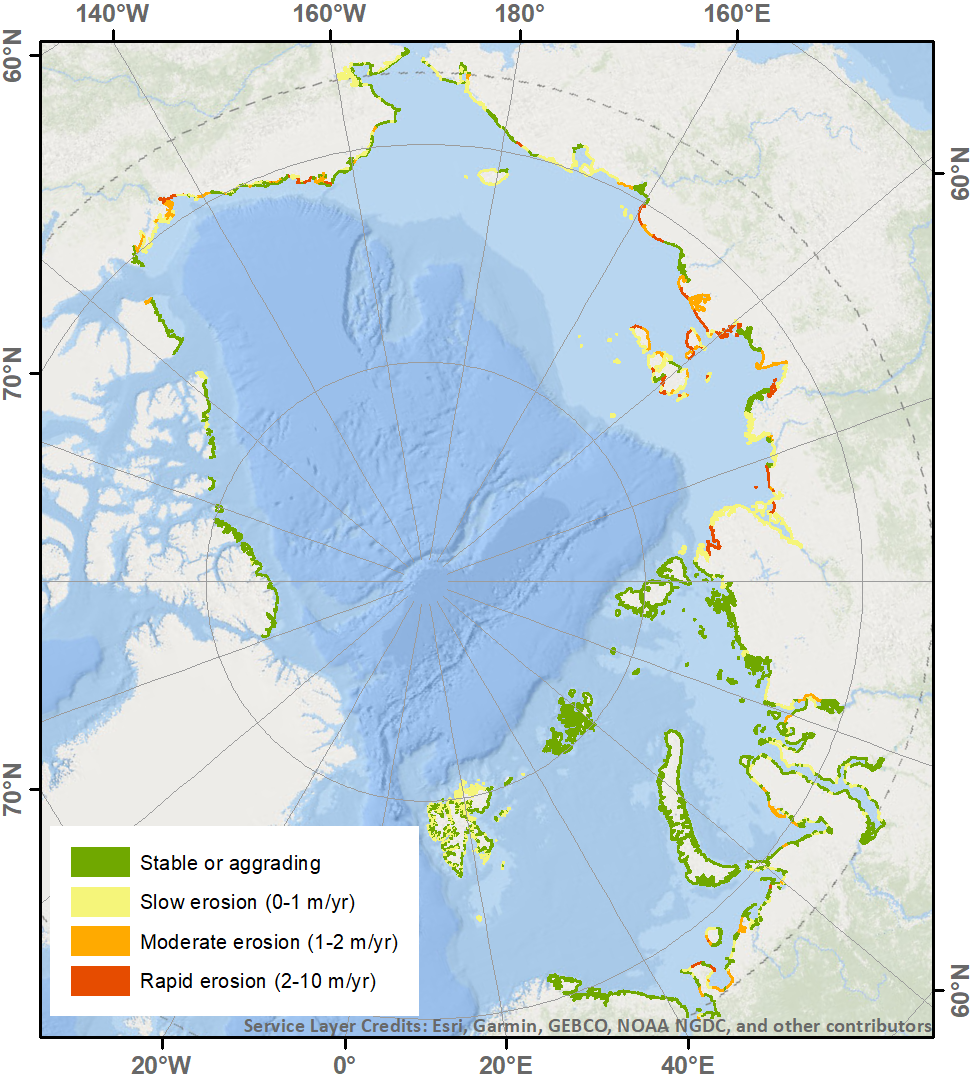
Arctic Coastal Dynamics Classification Database
An important outcome of Arctic Coastal Dynamics I was the segmentation and characterization of the entire circum-Arctic coastline by regional experts which is presented in this... -
Robust trends of landscape dynamics in the Arctic Lena Delta with temporally dense Landsat time-series stacks
The robust Theil-Sen regression algorithm was used to calculate trend parameters (slope, intercept, confidence intervals) on Landsat time-series stack in the north-east Siberian... -
Rockglacier and Slope Instability Inventory from differential SAR interferograms and optical imagery, 1998-2016,...
Rockglaciers and other periglacial processes were mapped using visual analysis of differential SAR interferograms and satellite optical images (Google Satellite, Bing Aerial)... -
Trends of Land Surface Change from Landsat time-series 1999-2014, Eastern Canada, UTM Zone 18N, 62°N - 64°N (CA)
The Hot Spot Regions of Permafrost Change (HRPC) product maps changes in surface characteristics using the full Landsat archive (TM, ETM+, OLI) for the peak summer season (July,... -
Trends of Land Surface Change from Landsat time-series 1999-2014, Eastern Canada, UTM Zone 18N, 60°N - 62°N (CA)
The Hot Spot Regions of Permafrost Change (HRPC) product maps changes in surface characteristics using the full Landsat archive (TM, ETM+, OLI) for the peak summer season (July,...


