-
Trends of Land Surface Change from Landsat time-series 1999-2014, Western Siberia, UTM Zone 42N, 60°N - 62°N (RU)
The Hot Spot Regions of Permafrost Change (HRPC) product maps changes in surface characteristics using the full Landsat archive (TM, ETM+, OLI) for the peak summer season (July,...
-
Trends of Land Surface Change from Landsat time-series 1999-2014, Western Siberia, UTM Zone 42N, 58°N - 60°N (RU)
The Hot Spot Regions of Permafrost Change (HRPC) product maps changes in surface characteristics using the full Landsat archive (TM, ETM+, OLI) for the peak summer season (July,...
-
Land Cover Classification from Sentinel-1 and Sentinel-2, 2015-2018, Western Siberia (RU)
Land cover classes have been derived from bands of Sentinel-2 (bands 3 (green, 10m), 4 (red, 10m), 8 (near infrared, 10m), 11 (SWIR, 20m) and 12 (SWIR, 20m)) as well as...
-
Land Cover Classification from Sentinel-1 and Sentinel-2, 2015-2018, Yukon Delta, Alaska (US)
Land cover classes have been derived from bands of Sentinel-2 (bands 3 (green, 10m), 4 (red, 10m), 8 (near infrared, 10m), 11 (SWIR, 20m) and 12 (SWIR, 20m)) as well as...
-
Land Cover Classification from Sentinel-1 and Sentinel-2, 2015-2018, Seward Peninsula, Alaska (US)
Land cover classes have been derived from bands of Sentinel-2 (bands 3 (green, 10m), 4 (red, 10m), 8 (near infrared, 10m), 11 (SWIR, 20m) and 12 (SWIR, 20m)) as well as...
-
Land Cover Classification from Sentinel-1 and Sentinel-2, 2015-2018, Lena Delta, Laptev and East Siberian Sea Region (RU)
Land cover classes have been derived from bands of Sentinel-2 (bands 3 (green, 10m), 4 (red, 10m), 8 (near infrared, 10m), 11 (SWIR, 20m) and 12 (SWIR, 20m)) as well as...
-
Land Cover Classification from Sentinel-1 and Sentinel-2, 2015-2018, Kytalyk, Central Yakutia (RU)
Land cover classes have been derived from bands of Sentinel-2 (bands 3 (green, 10m), 4 (red, 10m), 8 (near infrared, 10m), 11 (SWIR, 20m) and 12 (SWIR, 20m)) as well as...
-
Land Cover Classification from Sentinel-1 and Sentinel-2, 2015-2018, Umiaq, Canadian (Arctic) Archipelago (CA)
Land cover classes have been derived from bands of Sentinel-2 (bands 3 (green, 10m), 4 (red, 10m), 8 (near infrared, 10m), 11 (SWIR, 20m) and 12 (SWIR, 20m)) as well as...
-
Land Cover Classification from Sentinel-1 and Sentinel-2, 2015-2018, Teshekpuk, Alaska (US)
Land cover classes have been derived from bands of Sentinel-2 (bands 3 (green, 10m), 4 (red, 10m), 8 (near infrared, 10m), 11 (SWIR, 20m) and 12 (SWIR, 20m)) as well as...
-
Land Cover Classification from Sentinel-1 and Sentinel-2, 2015-2018, Barrow, Alaska (US)
Land cover classes have been derived from bands of Sentinel-2 (bands 3 (green, 10m), 4 (red, 10m), 8 (near infrared, 10m), 11 (SWIR, 20m) and 12 (SWIR, 20m)) as well as...
-
Water Body Classification from ENVISAT ASAR Wide Swath, 2007-2011, Alaska North Slope and Alaska Highway, Alaska (US)
The regional waterbody classification is derived from ENVISAT ASAR Wide Swath data with 150 m resolution. Maps represent the extent of water bodies for the summer months July...
-
Surface Soil Moisture from ENVISAT ASAR GM, 2005-2011, Alaska North Slope and Alaska Highway, Alaska (US)
The SAR Surface Soil Moisture (SSM) product is derived from the ENVISAT ASAR sensor operating in Global Monitoring (GM) mode. The SAR SSM product is a weekly mean composite at 1...
-
Lake Ice Classification from Sentinel-1, 2015-2018, Yamal, Western Siberia (RU)
Weekly lake ice classifications distinguish grounded ice and floating ice in lakes based on Sentinel-1A and Sentinel-1B synthetic aperture radar time-series with a resolution of...
-
Lake Ice Classification from Sentinel-1, 2015-2018, Lena Delta, Laptev and East Siberian Sea Region (RU)
Weekly lake ice classifications distinguish grounded ice and floating ice in lakes based on Sentinel-1A and Sentinel-1B synthetic aperture radar time-series with a resolution of...
-
Lake Ice Classification from Sentinel-1, 2015-2017, Mackenzie Delta, Beaufort Sea Region (CA)
Weekly lake ice classifications distinguish grounded ice and floating ice in lakes based on Sentinel-1A and Sentinel-1B synthetic aperture radar time-series with a resolution of...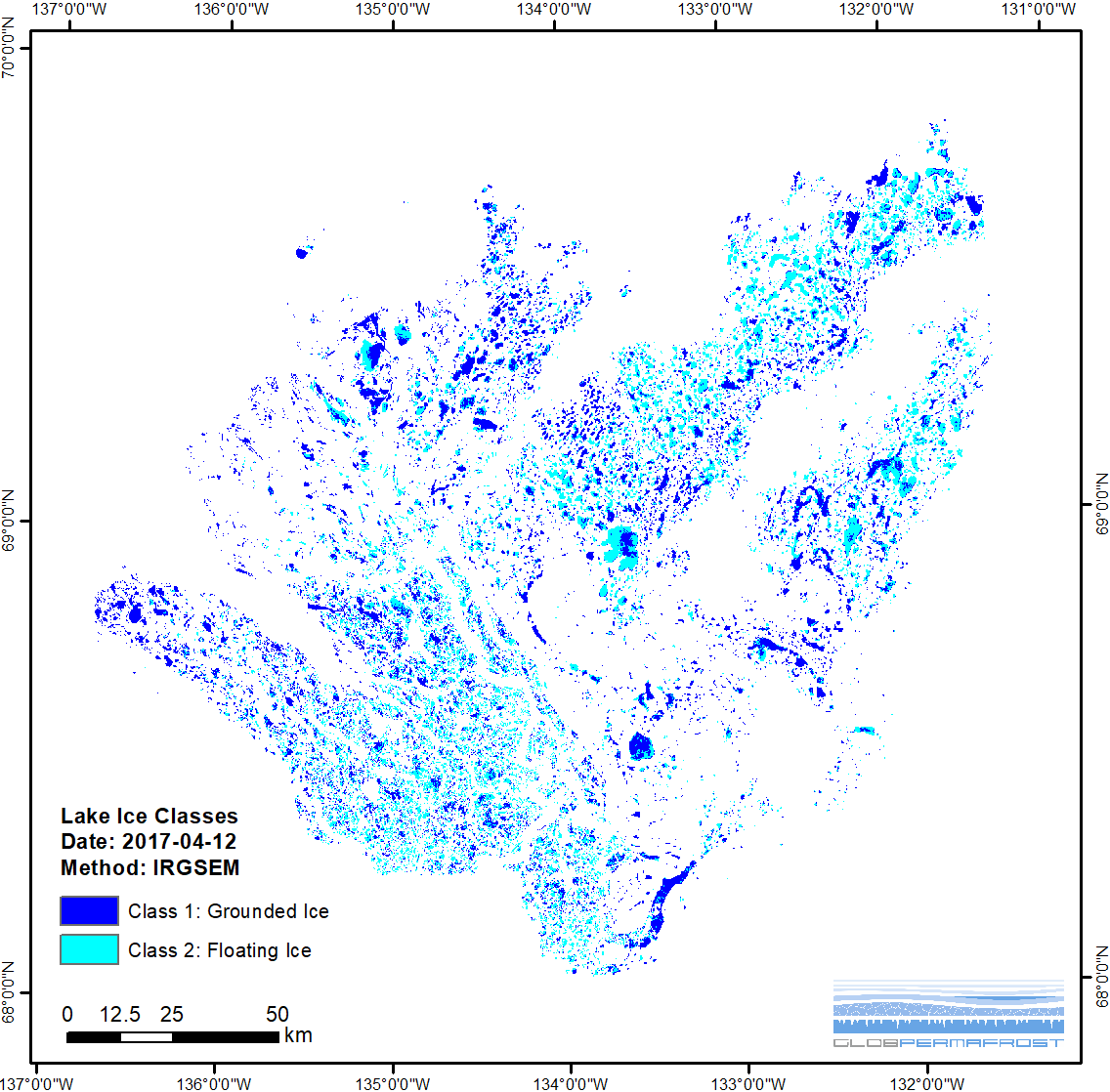
-
Lake Ice Classification from Sentinel-1, 2015-2017, Barrow, Alaska (US)
Weekly lake ice classifications distinguish grounded ice and floating ice in lakes based on Sentinel-1A and Sentinel-1B synthetic aperture radar time-series with a resolution of...
-
Lake Ice Classification from Sentinel-1, 2015-2016, Kytalyk, Central Yakutia (RU)
Weekly lake ice classifications distinguish grounded ice and floating ice in lakes based on Sentinel-1A and Sentinel-1B synthetic aperture radar time-series with a resolution of...

