-
ALLena: Thaw depth measurements of the active layer in the Lena River Delta region from 1998 to 2022, Northeastern...
Active layer thickness (ALT) is one of currently two Essential Climate Variables related directly to permafrost regions as defined by the Global Climate Observing System (GCOS)...
-
ALLena: Thaw depth measurements of the active layer in the Lena River Delta region from 1998 to 2022, Northeastern...
Active layer thickness (ALT) is one of currently two Essential Climate Variables related directly to permafrost regions as defined by the Global Climate Observing System (GCOS)...
-
ALLena: Thaw depth measurements of the active layer in the Lena River Delta region from 1998 to 2022, Northeastern...
Active layer thickness (ALT) is one of currently two Essential Climate Variables related directly to permafrost regions as defined by the Global Climate Observing System (GCOS)...
-
ALLena: Thaw depth measurements of the active layer in the Lena River Delta region from 1998 to 2022, Northeastern...
Active layer thickness (ALT) is one of currently two Essential Climate Variables related directly to permafrost regions as defined by the Global Climate Observing System (GCOS)...
-
ALLena: Thaw depth measurements of the active layer in the Lena River Delta region from 1998 to 2022, Northeastern...
Active layer thickness (ALT) is one of currently two Essential Climate Variables related directly to permafrost regions as defined by the Global Climate Observing System (GCOS)...
-
ALLena: Thaw depth measurements of the active layer in the Lena River Delta region from 1998 to 2022, Northeastern...
Active layer thickness (ALT) is one of currently two Essential Climate Variables related directly to permafrost regions as defined by the Global Climate Observing System (GCOS)...
-
ALLena: Thaw depth measurements of the active layer in the Lena River Delta region from 1998 to 2022, Northeastern...
Active layer thickness (ALT) is one of currently two Essential Climate Variables related directly to permafrost regions as defined by the Global Climate Observing System (GCOS)...
-
ALLena: Thaw depth measurements of the active layer in the Lena River Delta region from 1998 to 2022, Northeastern...
Active layer thickness (ALT) is one of currently two Essential Climate Variables related directly to permafrost regions as defined by the Global Climate Observing System (GCOS)...
-
ALLena: Thaw depth measurements of the active layer in the Lena River Delta region from 1998 to 2022, Northeastern...
Active layer thickness (ALT) is one of currently two Essential Climate Variables related directly to permafrost regions as defined by the Global Climate Observing System (GCOS)...
-
ALLena: Thaw depth measurements of the active layer in the Lena River Delta region from 1998 to 2022, Northeastern...
Active layer thickness (ALT) is one of currently two Essential Climate Variables related directly to permafrost regions as defined by the Global Climate Observing System (GCOS)...
-
ALLena: Thaw depth measurements of the active layer in the Lena River Delta region from 1998 to 2022, Northeastern Siberia
Active layer thickness (ALT) is one of currently two Essential Climate Variables related directly to permafrost regions as defined by the Global Climate Observing System (GCOS)...
-
Database of Ice-Rich Yedoma Permafrost (IRYP)
We synthesized data on the circum-Arctic and sub-Arctic distribution and thickness of Yedoma for compiling a preliminary circum-polar Yedoma map. For compiling this map, we used...
-
Database of Ice-Rich Yedoma Permafrost Version 2 (IRYP v2)
Ice-rich permafrost in the circum-Arctic and sub-Arctic, such as late Pleistocene Yedoma, are especially prone to degradation due to climate change or human activity. When...
-
Quaternary deposits map of Yana-Indigirka and Kolyma lowlands tundra zone, R-55-57, based on Landsat imagery
The Quaternary geology map was created for the Yana-Indigirka (eastern part) and Kolyma lowlands, tundra and partly forest-tundra zones. The map corresponds to the nomenclature...
-
Ground Temperature Map, 2000-2016, New Zealand
The product provides modeled mean annual ground temperatures (MAGT) at the top of the permafrost for New Zealand at 1 km spatial resolution. Permafrost probability (fraction...
-
T-MOSAiC 2021 myThaw data set, Circum-Arctic
The Terrestrial Multidisciplinary distributed Observatories for the Study of the Arctic Connections (T-MOSAiC) 2021 permafrost thaw data set provides standardized measurements...
-
Frozen State Backscatter Intensity from Sentinel-1, 2016-2017, Mackenzie Delta, Beaufort Sea Region (CA)
Frozen state backscatter intensity was derived from Sentinel-1 acquisitions from December 2015 and 2016. By excluding the effects of liquid water content (acquisitions under...
-
Dataset of a globally relevant stock of soil nitrogen in the Yedoma permafrost domain, 1998-2016, Circum-Arctic
This dataset merges nitrogen data from the Yedoma domain. It includes numerous fieldwork campaigns, which take place since 1998. In total 467 samples from the active layer...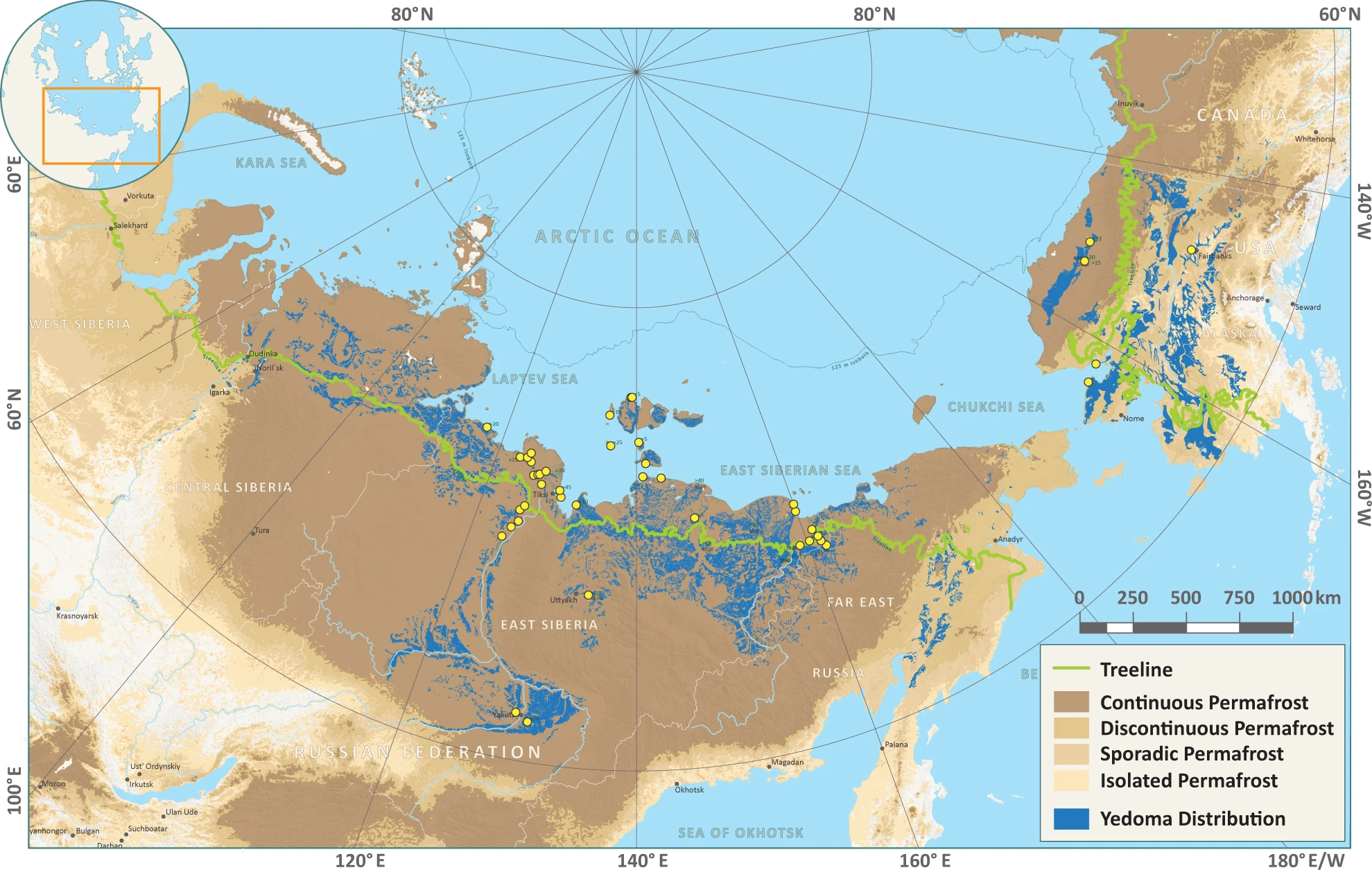
-
GTN-P (2015): Global Terrestrial Network for Permafrost metadata for permafrost boreholes (TSP) and active layer...
The Global Terrestrial Network for Permafrost (GTN-P) provides the first dynamic database associated with the Thermal State of Permafrost (TSP) and the Circumpolar Active Layer...
-
Database of Global Peatland Extent and Carbon Stocks through the Last Glacial Cycle (130 ka to present)
We present the first synthesis of global peatland extent through the last glacial cycle (130 ka) based on >975 detailed stratigraphic descriptions from exposures, soil pits,...