-
Database of Ice-Rich Yedoma Permafrost (IRYP)
We synthesized data on the circum-Arctic and sub-Arctic distribution and thickness of Yedoma for compiling a preliminary circum-polar Yedoma map. For compiling this map, we used...
-
Content of carbon isotopes (¹³C and ¹⁴C) in organic carbon pools in terrestrial Siberia
The dataset consists of one xlsx file with four sheets, listing (1) ¹³C and ¹⁴C data of litter and organic layers in northern Russia, Scandinavia, Canada and Alaska; (2) ¹³C and...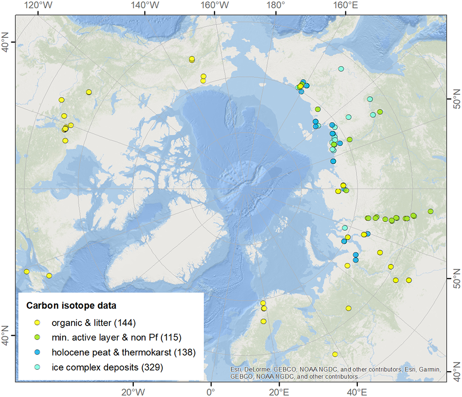
-
Total above-ground biomass of 25 sites from 2018 central Lena Delta (RU)
Field investigations were performed in the central Lena Delta. In total, 25 sites were investigated. The sites were chosen to represent a variety of vegetation communities of...
-
ABoVE: Atmospheric Gas Concentrations from Airborne Flasks, Arctic-CAP, 2017
This dataset provides atmospheric carbon dioxide (CO2), methane (CH4), carbon monoxide (CO), molecular hydrogen (H2), nitrous oxide (N2O), sulfur hexafluoride (SF6), and other...
-
ABoVE/ASCENDS: Active Sensing of CO2, CH4, and Water Vapor, Alaska and Canada, 2017
This dataset provides in situ airborne measurements of atmospheric carbon dioxide (CO2), methane (CH4), and water vapor concentrations, plus air temperature, pressure, relative...
-
Gridded inventory of Canada's anthropogenic methane emissions for 2018
This dataset contains a gridded inventory of Canada's 2018 anthropogenic methane emissions at 0.1 x 0.1 degree. National and provincial emission totals in the inventory match...
-
Anaerobic incubation measurements (CH4+CO2) and microbe quantification, Lena Delta, 2018
The data sets were made during the summer 2021, with samples collected from three cores, at two depths (active and permafrost layers). In total, six samples (3 replicates by...
-
ABoVE: Methane Ebullition Hotspots in Frozen Lakes near Fairbanks, Alaska, Oct 2014
This dataset includes maps of the locations and number of methane ebullition hotspots in 15 frozen lakes in the southern portion of the Goldstream Valley and the surrounding...
-
Inorganic and organic hydrochemistry of lakes and ponds in continuous permafrost landscapes in the western Canadian...
Between 2006 and 2015 inorganic and organic hydrochemical parameters and stable water isotope characteristics were measured in lakes and ponds in continuous permafrost...
-
Remote sensing reflectance (Rrs) of the surface water during 4 expeditions from spring to fall in 2019, Mackenzie...
Vertical profiles of downwelling irradiance (Ed) and upwelling radiance (Lu) were measured during legs 2, 3, and 4 using a Compact-Optical Profiling System (C-OPS) in an ICE-Pro...
-
Particle absorption (aP) in the surface water during 4 expeditions from spring to fall in 2019, Mackenzie Delta Region (CA)
Absorbance of particles retained on GF/F (0.7 µm) filters was measured using a Varian Cary 100 spectrophotometer equipped with an integrated sphere. Absorbance and reflectance...
-
Phytoplankton pigment concentrations measured by HPLC in the surface water during 4 expeditions from spring to fall...
The determination of phytoplankton using high performance liquid chromatography (HPLC) is detailed in Hooker et al. (2005; doi:10.1364/AO.44.000553) and Ras et al. (2008;...
-
Stable water isotopes (δ18O, δD, d-excess) in the surface water during 4 expeditions from spring to fall in 2019,...
Water samples for stable isotopes were collected untreated in 10 mL HDPE vials, sealed tightly, stored in the dark at 4°C. Measurements were conducted at the laboratory facility...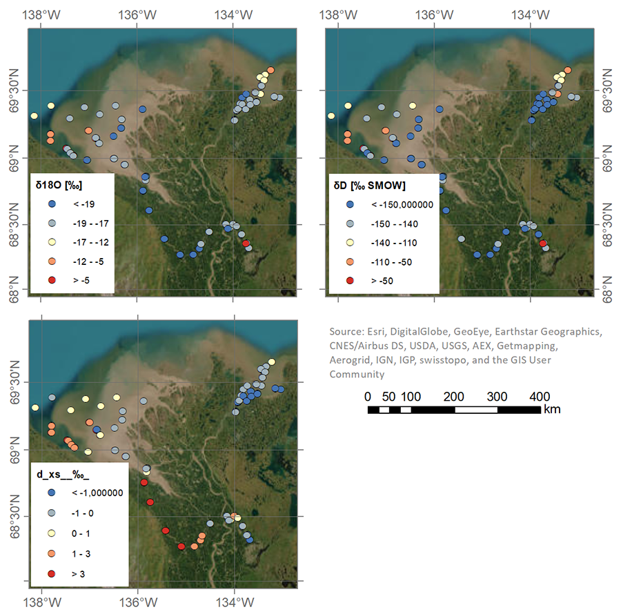
-
Dissolved organic carbon (DOC) concentration in the surface water during 4 expeditions from spring to fall in 2019,...
Water samples were filtered through 0.7 µm GF/F filter, and acidified with 25 µL Suprapur HCl (10 M) on the same day of sampling. DOC samples were stored and kept at 4°C in the...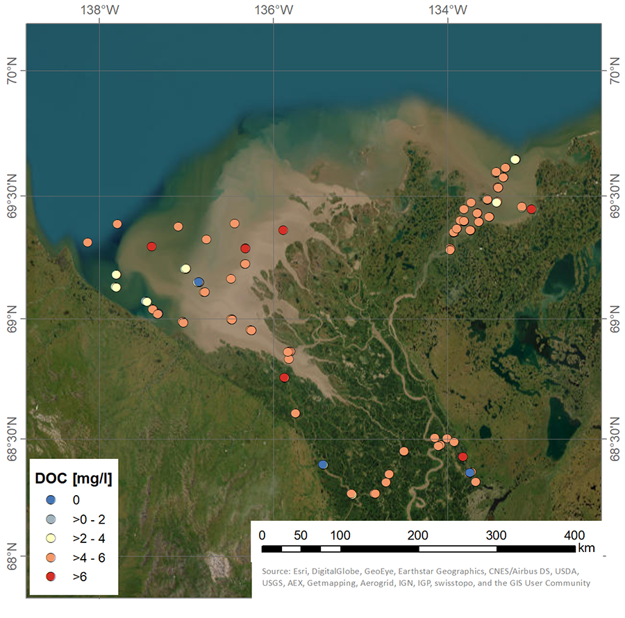
-
Bacteria cells in the surface water during 4 expeditions from spring to fall in 2019, Mackenzie Delta Region (CA)
Samples for bacterial abundance (1.5 mL) were preserved with glutaraldehyde (1% final concentration) and stored at -80°C. Samples were stained with SYBRTM Green I (Thermofisher...
-
Particulate organic carbon (POC) and particulate organic nitrogen (PON) concentrations in the surface water during 4...
Particulate organic carbon (POC) and particulate organic nitrogen (PON) concentrations were obtained from water samples filtered on precombusted (450°C for >5 hours) 47mm...
-
Suspended particulate matter (SPM), Total particulate carbon (TPC) and Total particulate nitrogen (TPN)...
Material for the determination of suspended particulate matter (SPM), total particulate carbon (TPC) and total particulate nitrogen (TPN) was obtained by filtering 300-700 mL...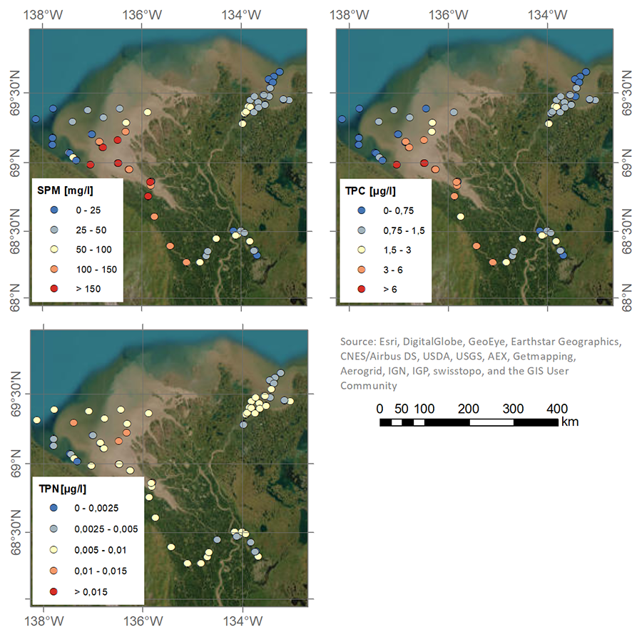
-
Nutrient (NO3, NO2, PO4, SiO4) concentrations in the surface water during 4 expeditions from spring to fall in 2019,...
Water for nitrate (NO3), nitrite (NO2), phosphate (PO4) and silicate (SiO4) was filtered using an acid-washed 60-mL luer-lock syringe combined with an Acrodisc filter (GF/F 0.7...
-
Methane flux from closed chamber with spectrometer across two thermokarst lake ecosystems, 2018, Interior Alaska (US)
This dataset provides diffusive methane (CH4) fluxes collected from two thermokarst lakes in the Goldstream Valley, north of Fairbanks in interior Alaska. Fluxes were collected...
-
Methane Fluxes from Shorelines and Differing Surfaces, 2019, Big Trail Lake, Alaska (US)
This dataset provides methane fluxes from hot-spot and non-hot spot differing surfaces at Big Trail Lake (BTL) in the Goldstream Valley near Fairbanks, AK, USA. Measurements...