-
DARTS: Multi-year database of AI detected retrogressive thaw slumps (RTS) in hotspots of the circum-arctic...
This dataset, called DARTS, comprises footprints of active parts of retrogressive thaw slump (RTS) identified and quantified using an automated deep learning approach in RTS...
-
DARTS: Multi-year database of AI detected retrogressive thaw slumps (RTS) and active layer detachment slides (ALD)...
This dataset, called DARTS, comprises footprints of retrogressive thaw slump (RTS) and active layer detachments slides (ALD) identified and quantified using an automated deep... -
Super-high-resolution aerial imagery, digital surface model and 3D point cloud of Herschel Island, Canada
As part of the MOSES airborne campaign led by the Alfred Wegener Institute in 2018, we collected super-high-resolution multispectral imagery of permafrost landscapes with the...
-
Super-high-resolution aerial imagery, digital surface model and 3D point cloud of the Noatak River Slump, Alaska
As part of the Perma-X airborne campaign led by the Alfred Wegener Institute in 2021, we collected super-high-resolution multispectral imagery of permafrost landscapes with the...
-
Annual dynamics of rapid permafrost disturbances from Landsat and Sentinel-2, 2000-2019, Northeast Siberia (RU)
Permafrost is warming globally which leads to widespread permafrost thaw. Particularly ice-rich permafrost is vulnerable to rapid thaw and erosion, impacting whole landscapes...
-
Dataset for Assessing volumetric change distributions and scaling relations of thaw slumps across the Arctic
Arctic ice-rich permafrost is becoming increasingly vulnerable to terrain-altering thermokarst, and among the most rapid and dramatic of these changes are retrogressive thaw...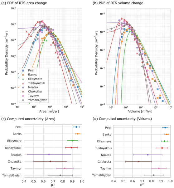
-
Coastal Retrogressive Thaw Slumps from GeoEye-1, WorldView-2 and Aerial Photographs, 2011, Yukon Coast (CA)
Coastal retrogressive thaw slumps (RTSs) were manually digitized at a 1:2000 scale using ArcMap (ESRI, version 10.3) from high‐resolution satellite images acquired in July (13...