-
ABoVE: Lake and Wetland Classification from L-band SAR, Alaska and Canada, 2017-2019
This dataset contains a high-resolution land cover classification focused on water and wetland vegetation classes over three NASA ABoVE Campaign regions: Yukon Flats, Alaska,...
-
Soil respired radiocarbon as CO2 and CH4 from permafrost in subarctic Canada, 2013 & 2014
This dataset contains measures of soil respired radiocarbon as CO2 and CH4 from peatland plateaus and thawing peatland plateaus and from burnt and unburnt forests from...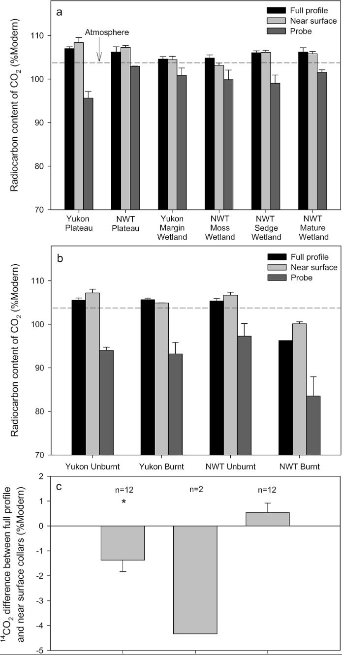
-
Wetland maps including open water extent dynamics based on ENVISAT ASAR WS for Siberia, 2007 and 2008
Wetlands store large amounts of carbon, and depending on their status and type, they release specific amounts of methane gas to the atmosphere. The connection between wetland...
-
The fractional land cover estimates from the Boreal–Arctic Wetland and Lake Dataset (BAWLD), 2021, Circum-Arctic
The Boreal and Arctic Wetland and Lake Dataset (BAWLD) provides estimates of fractional land cover of 19 land cover classes within 0.5° ×0.5° grid cells. The total area of the...
-
Growing season, non-growing season and annual CH4 fluxes from temperate, boreal, and Arctic wetlands and uplands,...
Wetlands are the single largest natural source of atmospheric methane (CH4), a greenhouse gas, and occur extensively in the northern hemisphere. Large discrepancies remain...
-
The Wetland and Wetland CH4 Inter-comparison of Models Project (WETCHIMP) data archive
This archive contains the raw and post-processed model output used in the The Wetland and Wetland CH4 Inter-comparison of Models Project (WETCHIMP). There are top-level...