-
Raster Circumpolar Arctic Vegetation Map (CAVM) from AVHRR, MODIS and elevation data
Land cover maps are the basic data layer required for understanding and modeling ecological patterns and processes. The Circumpolar Arctic Vegetation Map (CAVM), produced in...
-
Permafrost Region Pond and Lake Database (PeRL)
The Permafrost Region Pond and Lake Database (PeRL) presents the results of a circum-arctic effort to map ponds and lakes from modern (2002-2013) high-resolution aerial and...
-
Circumpolar raster grids of permafrost extent and geohazard potential for near-future climate scenarios
One of the consequences of warming climate is rising ground temperatures and degradation of perennially frozen ground, permafrost. Thawing of near-surface permafrost can cause...
-
Remotely-sensed Arctic Discharge Reanalysis (RADR) from discharge observations and Landsat, 1984-2018, Circum-Arctic
Arctic rivers drain ~15% of the global land surface and significantly influence local communities and economies, freshwater and marine ecosystems, and global climate. However,...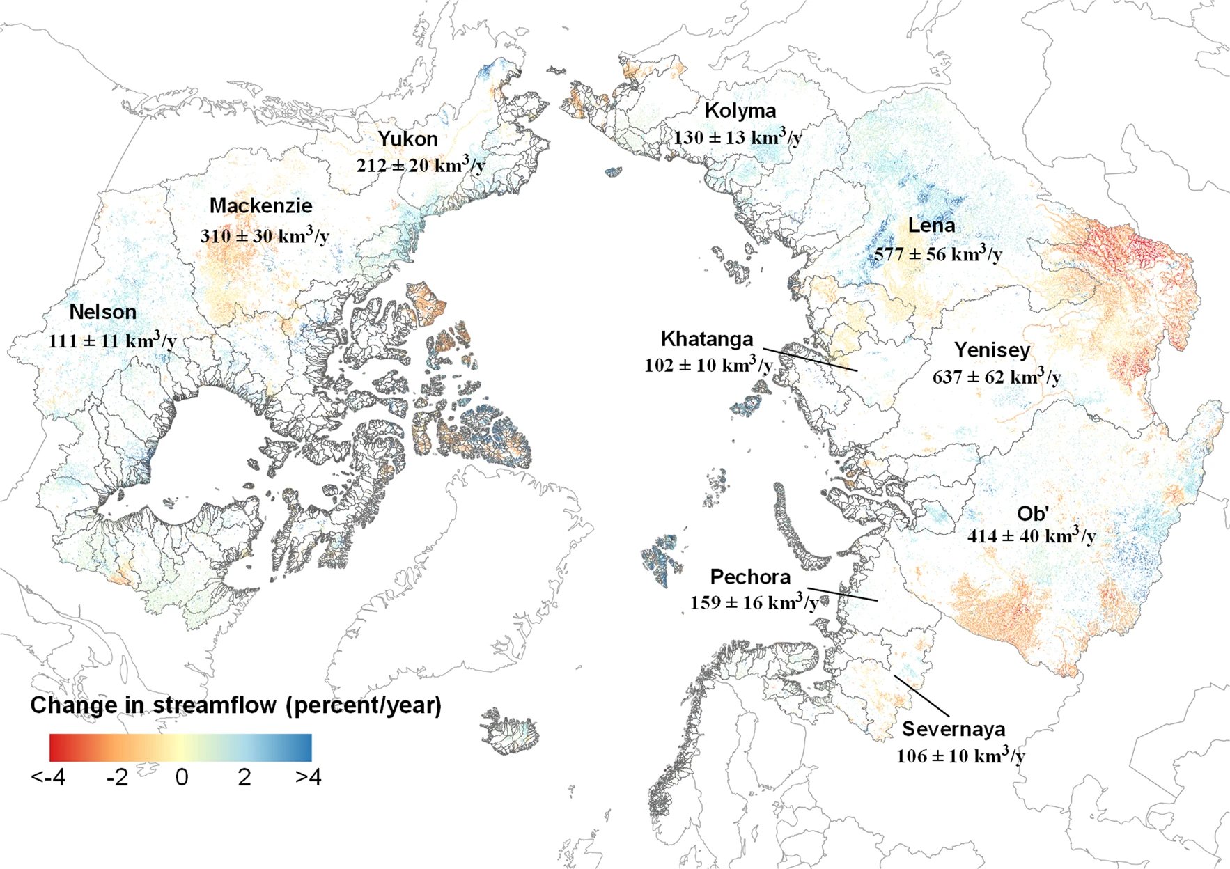
-
Permafrost active layer thickness for the Northern Hemisphere, v3.0 from MODIS LST, ERA5, 1997-2019
This dataset contains permafrost active layer thickness data produced as part of the European Space Agency's (ESA) Climate Change Initiative (CCI) Permafrost project. It forms...
-
Permafrost active layer thickness for the Northern Hemisphere, v2.0 from MODIS LST, ERA5, 1997-2018
This dataset contains permafrost active layer thickness data produced as part of the European Space Agency's (ESA) Climate Change Initiative (CCI) Permafrost project. It forms...
-
Permafrost extent for the Northern Hemisphere, v3.0 from MODIS LST, ERA5, 1997-2019
This dataset contains permafrost extent data produced as part of the European Space Agency's (ESA) Climate Change Initiative (CCI) Permafrost project. It forms part of the...
-
Permafrost ground temperature for the Northern Hemisphere, v3.0 from MODIS LST, ERA5, 1997-2019
This dataset contains permafrost ground temperature data produced as part of the European Space Agency's (ESA) Climate Change Initiative (CCI) Permafrost project. It forms part...
-
Permafrost ground temperature for the Northern Hemisphere, v2.0 from MODIS LST, ERA5, 1997-2018
This dataset contains permafrost ground temperature data produced as part of the European Space Agency's (ESA) Climate Change Initiative (CCI) Permafrost project. It forms part...
-
Permafrost extent for the Northern Hemisphere, v2.0 from MODIS LST, ERA5, 1997-2018
This dataset contains permafrost extent data produced as part of the European Space Agency's (ESA) Climate Change Initiative (CCI) Permafrost project. It forms part of the first...
-
Dataset for Assessing volumetric change distributions and scaling relations of thaw slumps across the Arctic
Arctic ice-rich permafrost is becoming increasingly vulnerable to terrain-altering thermokarst, and among the most rapid and dramatic of these changes are retrogressive thaw...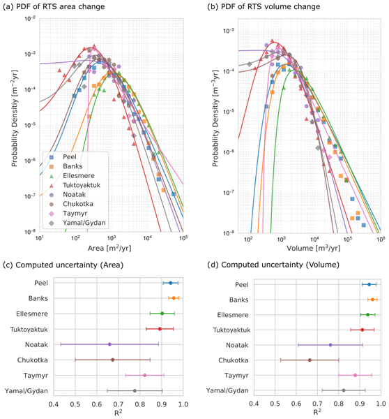
-
Arctic Coastal Dynamics Classification Database
An important outcome of Arctic Coastal Dynamics I was the segmentation and characterization of the entire circum-Arctic coastline by regional experts which is presented in this...
-
Permafrost Extent and Ground Temperature Map, 2000-2016, Northern Hemisphere Permafrost
The product provides modeled mean annual ground temperatures (MAGT) at the top of the permafrost for the Northern Hemisphere at 1 km spatial resolution. Permafrost probability...
-
Point Pedon Data of the Northern Circumpolar Soil Carbon Database, Circum-Arctic
The Northern Circumpolar Soil Carbon Database version 2 (NCSCDv2) is a geospatial database created for the purpose of quantifying storage of organic carbon in soils of the...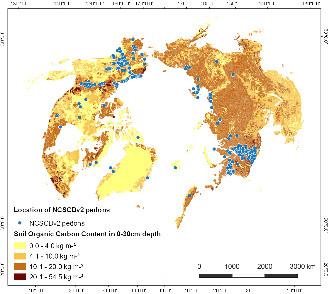
-
Submarine Permafrost Map (SuPerMAP), modeled with CryoGrid 2, Circum-Arctic
This data set contains a first‐order estimate of distribution, thickness and ice-content of submarine permafrost on the Arctic shelf based on a numerical heat transfer model....
-
Northern Circumpolar Soil Carbon Database, Circum-Arctic Region, shape-files
The Northern Circumpolar Soil Carbon Database version 2 (NCSCDv2) is a geospatial database created for the purpose of quantifying storage of organic carbon in soils of the...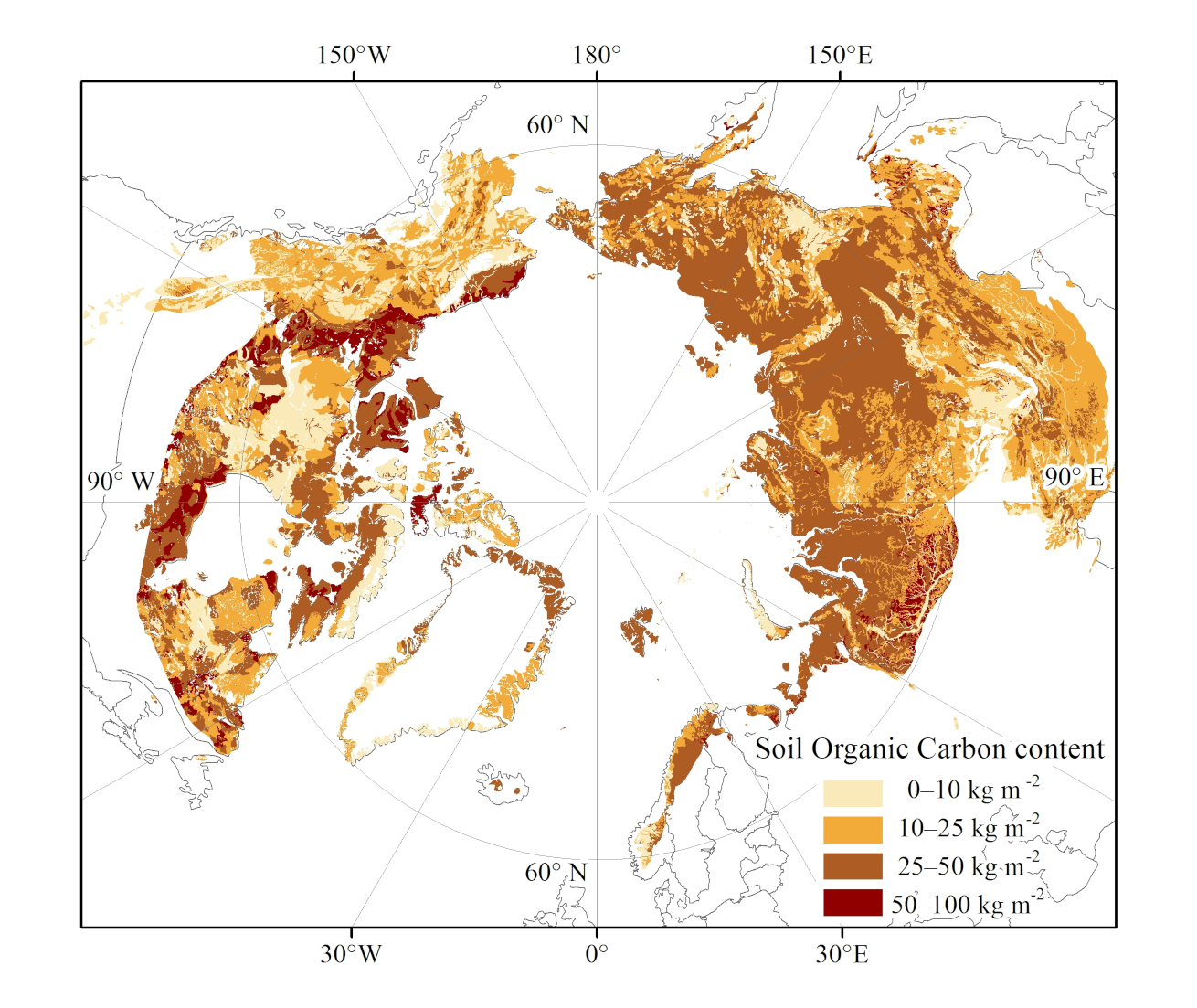
-
Northern Circumpolar Soil Carbon Database, Circum-Arctic Region, geotiff-files
The Northern Circumpolar Soil Carbon Database version 2 (NCSCDv2) is a geospatial database created for the purpose of quantifying storage of organic carbon in soils of the...
-
Lake Basal Ages and Origins from scientific literature, Circum-Arctic
This dataset is a compilation of 1,207 lake basal ages used to identify spatial and temporal patterns of lake formation across the high northern latitudes. Data was gathered...
-
Weekly Land Surface Temperature from MODIS, 2007-2013, Circum-Arctic Region
Weekly land surface temperature (LST) products of the ESA Data User Element (DUE) Permafrost are provided at 1 km spatial resolution. Weekly LST are available for the years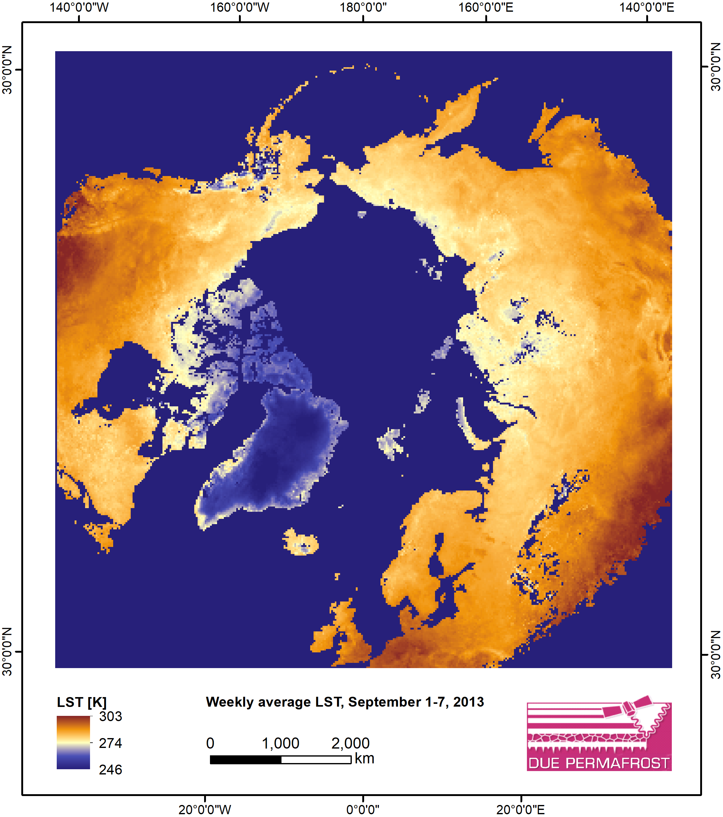
Monthly Land Surface Temperature from MODIS, 2007-2013, Circum-Arctic Region
Monthly land surface temperature (LST) products of the ESA Data User Element (DUE) Permafrost are provided at 1 km spatial resolution for the