-
Land Surface Feature Classification from TerraSAR-X, 2013, Barrow, Alaska (US)
Land surface features (water, wetland, tundra, and bare surfaces) were classified from TerraSAR-X with a resolution of 5 m for the period of July and August 2013. The product is...
-
Laboratory soil incubation respiration rates from permafrost in subarctic Canada, 2013 & 2014
This dataset contains measures of laboratory soil incubation respiration rates from permafrost in subarctic Canada. Soil cores were sampled from a peatland plateau and a thawing...
-
Soil and incubation data of permafrost-affected soils in Samoylov, 2011 & 2013
The effects of oxygen availability, freezing and thawing, temperature, and labile organic matter (OM) additions on greenhouse gas production were studied in northeast Siberian...
-
Land Surface Feature Classification from TerraSAR-X, 2013, Kytalyk, Central Yakutia (RU)
Land surface features (water, wetland, tundra, and bare surfaces) were classified from TerraSAR-X with a resolution of 5 m for July 2013. The product is based on the...
-
Gridded monthly methane emissions from terrestrial wetlands, north of 45 °N, 2013-2014
This dataset provides wetland methane (CH4) emissions, their uncertainties and underlying CH4 flux densities north from 45 N using three different wetland maps. The data...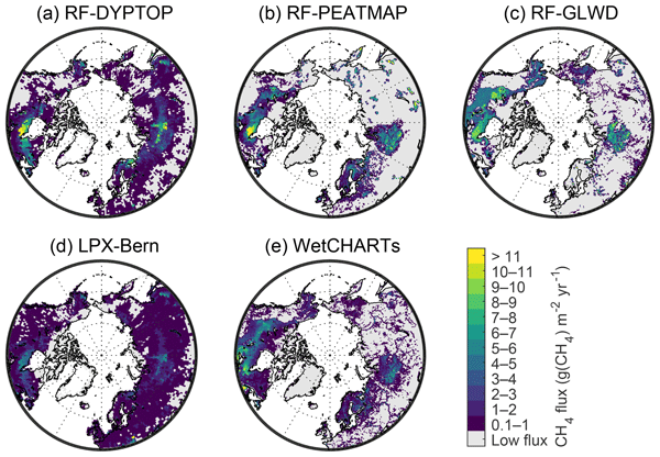
-
Methane fluxes from burnt and unburnt forests from permafrost in subarctic Canada, 2013 & 2014
This dataset contains methane fluxes from peatland plateaus and thawing peatland plateaus and from burnt and unburnt forests from permafrost in subarctic Canada. Methane fluxes...
-
Methane fluxes, soil gas profiles and microbial activities in ponds at Samoylov, 2002 & 2013
Methane (CH4) production, oxidation, and emission were studied in ponds of the permafrost-affected polygonal tundra in northeast Siberia. Summer CH4 fluxes were measured with...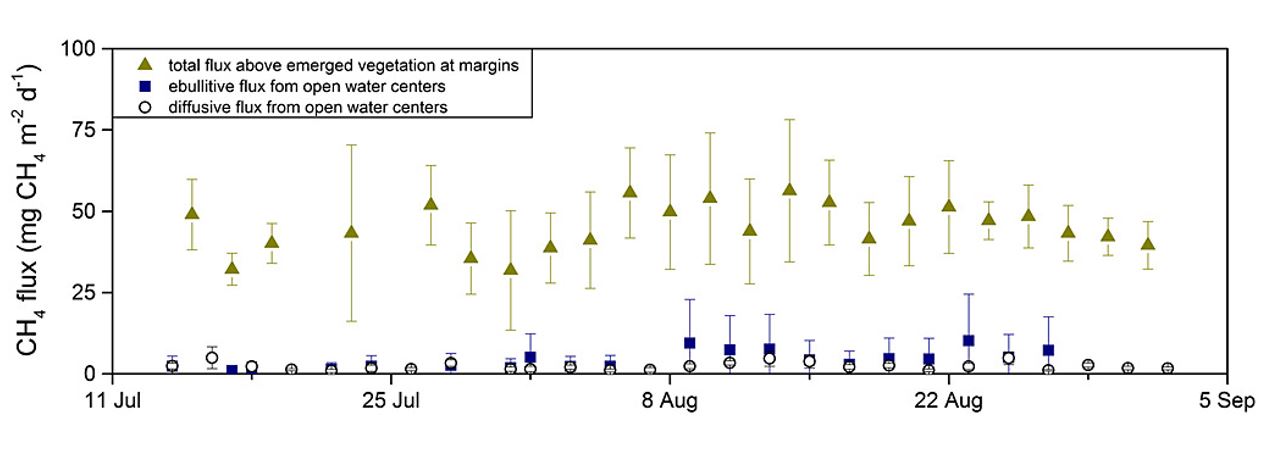
-
Land Surface Feature Classification from TerraSAR-X, 2013, Mackenzie Delta, Beaufort Sea Region (CA)
Land surface features (water, wetland, tundra, and bare surfaces) were classified from TerraSAR-X with a resolution of 5 m for the period of July and August 2013. The product is...
-
Soil respired radiocarbon as CO2 and CH4 from permafrost in subarctic Canada, 2013 & 2014
This dataset contains measures of soil respired radiocarbon as CO2 and CH4 from peatland plateaus and thawing peatland plateaus and from burnt and unburnt forests from...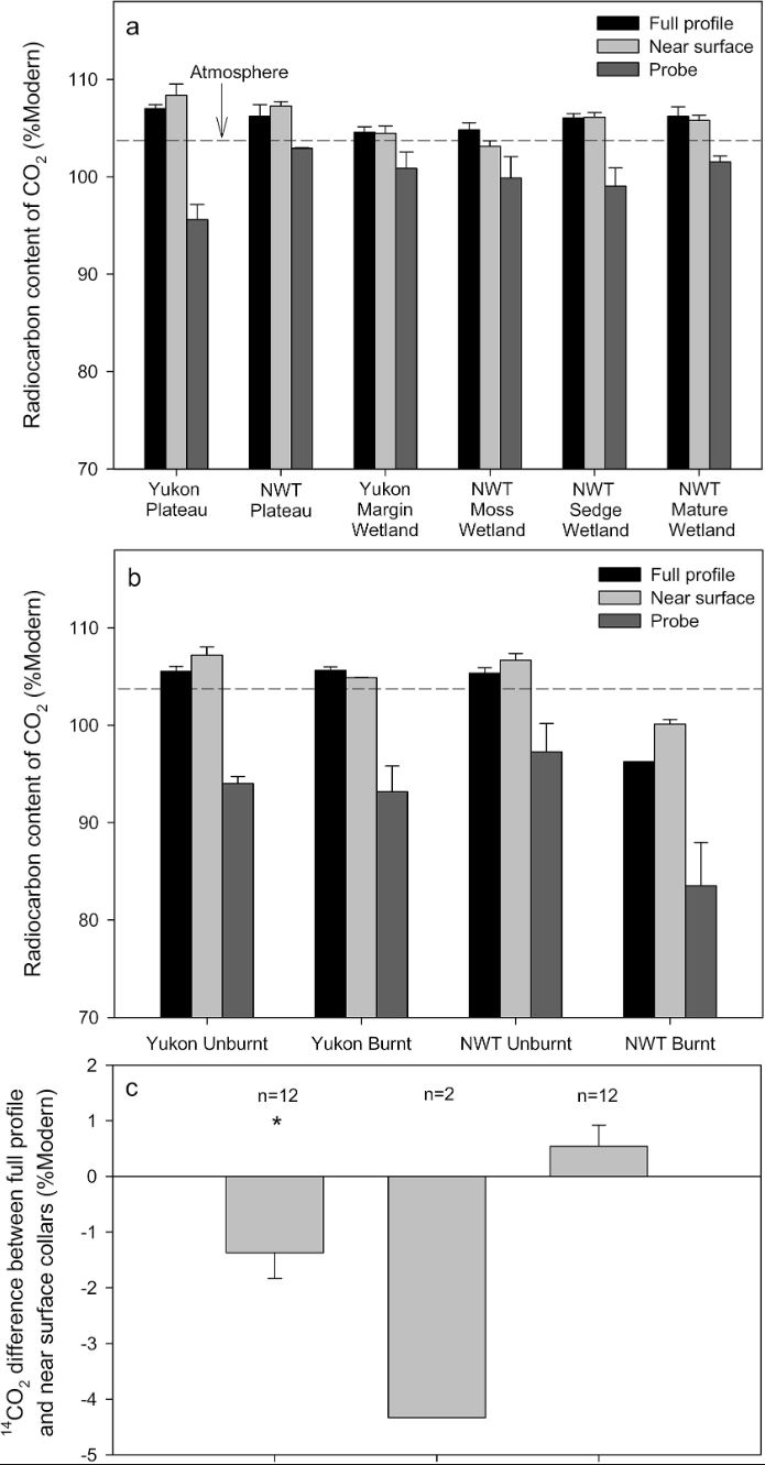
-
Land Surface Feature Classification from TerraSAR-X, 2013, Lena Delta, Laptev and East Siberian Sea Region (RU)
Land surface features (water, wetland, tundra, and bare surfaces) were classified from TerraSAR-X with a resolution of 5 m for August 2012 and July 2014. The product is based on...
-
CO2 and CH4 Production in Soil Incubations from Low and High Centered Polygons, Barrow, Alaska, 2012-2013
The dataset consists of respiration and methane production rates obtained from soil microcosm studies carried out under controlled temperature and incubation conditions. Soils...
-
The Wetland and Wetland CH4 Inter-comparison of Models Project (WETCHIMP) data archive
This archive contains the raw and post-processed model output used in the The Wetland and Wetland CH4 Inter-comparison of Models Project (WETCHIMP). There are top-level...
-
Chamber measured methane transport through individual aerenchymous plants at a boreal fen and a bog
The presented dataset contains chamber measurements of methane transport (mg CH₄ g dry plant mass-1 day-1) through individual aerenchymous peatland plants and the ancillary data...
-
CARVE atmospheric gas concentrations, airborne spectrometer, Alaska, 2012-2015
This data set provides atmospheric carbon dioxide (CO2), methane (CH4), carbon monoxide (CO), ozone (O3), and water vapor (H2O) concentrations from airborne campaigns over the...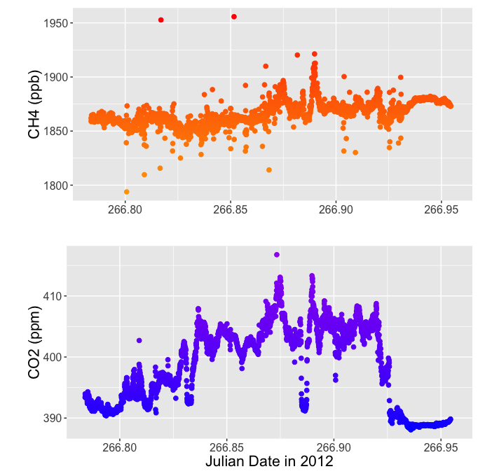
-
Eddy covariance carbon fluxes and ancillary data, Samoylov Island, Lena River Delta, 2014-2015
This dataset contains fluxes of carbon dioxide and methane on an active flood plain in the Siberian Lena River Delta during the growing seasons 2014 and 2015 by means of the...
-
CARVE atmospheric gas concentrations, tower based, Alaska, 2012-2015
This data set provides atmospheric methane (CH4), carbon dioxide (CO2), and carbon monoxide (CO) dry air mole fractions and water vapor mole fractions (H2O) from continuous in...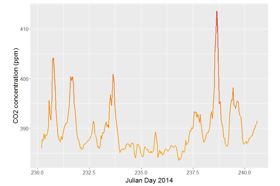
-
Permafrost active layer thickness for the Northern Hemisphere, v3.0 from MODIS LST, ERA5, 1997-2019
This dataset contains permafrost active layer thickness data produced as part of the European Space Agency's (ESA) Climate Change Initiative (CCI) Permafrost project. It forms...
-
Permafrost extent for the Northern Hemisphere, v3.0 from MODIS LST, ERA5, 1997-2019
This dataset contains permafrost extent data produced as part of the European Space Agency's (ESA) Climate Change Initiative (CCI) Permafrost project. It forms part of the...
-
Permafrost ground temperature for the Northern Hemisphere, v3.0 from MODIS LST, ERA5, 1997-2019
This dataset contains permafrost ground temperature data produced as part of the European Space Agency's (ESA) Climate Change Initiative (CCI) Permafrost project. It forms part...
-
ABoVE: Methane Ebullition Hotspots in Frozen Lakes near Fairbanks, Alaska, Oct 2014
This dataset includes maps of the locations and number of methane ebullition hotspots in 15 frozen lakes in the southern portion of the Goldstream Valley and the surrounding...