-
SAR-based Methane Ebullition Flux from Lakes, Five Regions, Alaska, 2007-2010
This dataset provides Synthetic Aperture Radar (SAR) estimates of lake-source methane ebullition flux in mg CH4/m2/d for thousands of lakes in five regions across Alaska. The...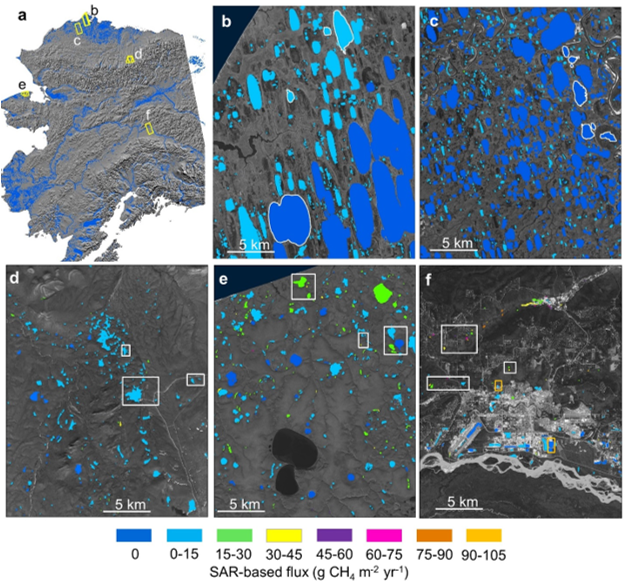
-
Northern Circumpolar Soil Carbon Database, Alaska, geotiff- and netCDF-files
The Northern Circumpolar Soil Carbon Database version 2 (NCSCDv2) is a geospatial database created for the purpose of quantifying storage of organic carbon in soils of the...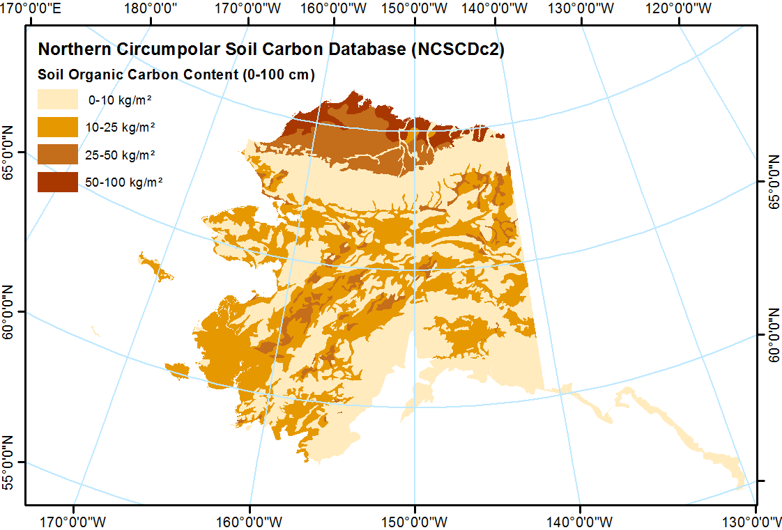
-
Global methane column-averaged dry air mole fraction (XCH4) from TROPOMI WFM-DOAS, since 2017
Carbon monoxide (CO) is an important atmospheric constituent affecting air quality, and methane (CH4) is the second most important greenhouse gas contributing to human-induced...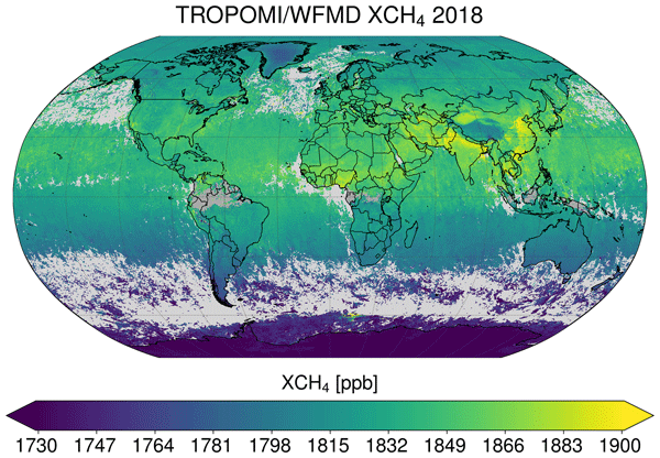
-
Eddy covariance measurements of methane flux from freshwater wetlands, 2006-2018, Global
FLUXNET-CH4 is an initiative led by the Global Carbon Project, in close partnership with AmeriFlux and EuroFlux, to compile a global database of eddy covariance (EC) methane...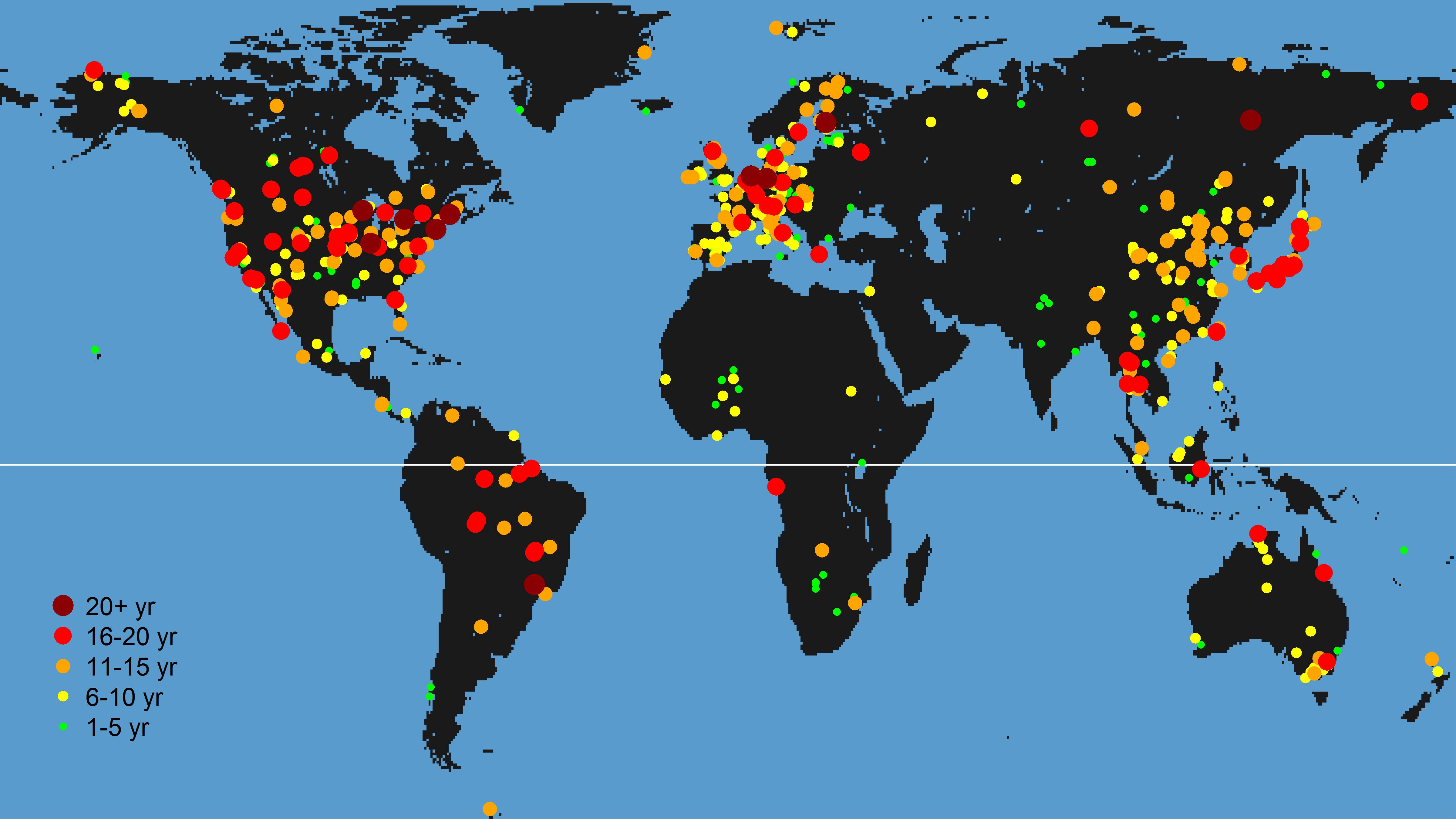
-
ABoVE: Methane Ebullition Hotspots in Frozen Lakes near Fairbanks, Alaska, Oct 2014
This dataset includes maps of the locations and number of methane ebullition hotspots in 15 frozen lakes in the southern portion of the Goldstream Valley and the surrounding...
-
Developing and Testing a Deep Learning Approach for Mapping Retrogressive Thaw Slumps (CA, RU)
In a warming Arctic, permafrost-related disturbances, such as retrogressive thaw slumps (RTS), are becoming more abundant and dynamic, with serious implications for permafrost...
-
TCCON data from Sodankylä, Lapland (FI), Release GGG2020.R0
The Total Carbon Column Observing Network (TCCON) is a network of ground-based Fourier Transform Spectrometers that record direct solar absorption spectra of the atmosphere in... -
UAV-based methane data from Barter Island, September 2017, Barrow, 1986-2017, Alaska (US)
Arctic permafrost stores vast amounts of methane (CH4) in subsurface reservoirs. Thawing permafrost creates areas for this potent greenhouse gas to be released to the...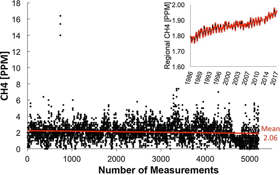
-
Pan-Arctic Visualization of Landscape Change (2003-2022), Arctic PASSION Permafrost Service
This raster dataset, in Cloud Optimized GeoTIFF format (COG), provides information on land surface changes at the pan-arctic scale. Multispectral Landsat-5 TM, Landsat-7 ETM+,...
-
Frozen State Backscatter Intensity from Sentinel-1, 2016-2017, Mackenzie Delta, Beaufort Sea Region (CA)
Frozen state backscatter intensity was derived from Sentinel-1 acquisitions from December 2015 and 2016. By excluding the effects of liquid water content (acquisitions under...
-
Land Surface Feature Classification from TerraSAR-X, 2013, Lena Delta, Laptev and East Siberian Sea Region (RU)
Land surface features (water, wetland, tundra, and bare surfaces) were classified from TerraSAR-X with a resolution of 5 m for August 2012 and July 2014. The product is based on...
-
Global 0.5-deg Wetland Methane Emissions and Uncertainty (WetCHARTs v1.0), 2009-2010
This data set provides global monthly wetland methane (CH4) emissions and uncertainty data products derived from an ensemble of multiple terrestrial biosphere models, wetland...
-
Global-Gridded Daily Methane Emissions from Inland Dam-Reservoir Systems, 2002-2015
This dataset includes global maps of methane (CH4) emissions from inland dam-reservoir systems at 0.25-degree spatial resolution. Daily emission rates (as grams of CH4 per day...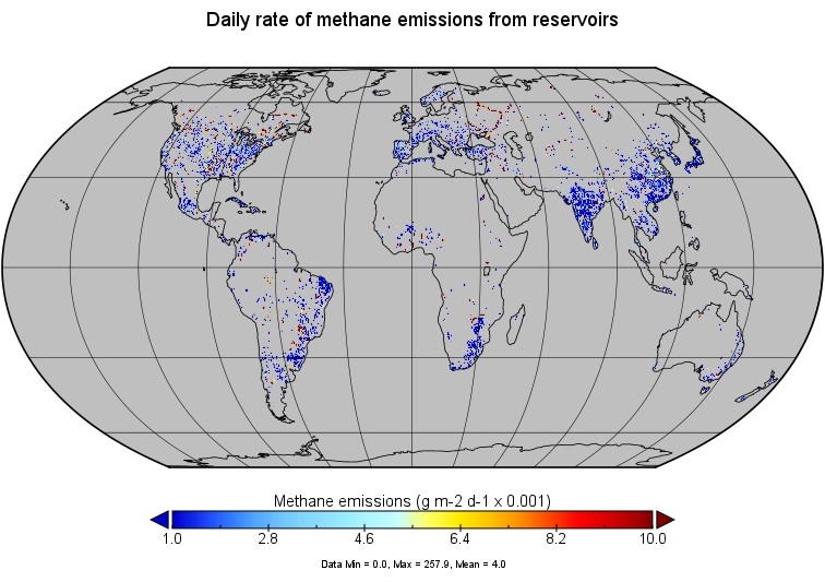
-
CARVE column gas from Airborne fourier transform spectrometer, Alaska, 2012-2015
This data set provides total vertical column O2, CO2, CH4, CO, and H2O, as well as dry-air columns of CO2, CH4, CO, and H2O from airborne campaigns over the Alaskan and Canadian...
-
CARVE atmospheric gas concentrations, tower based, Alaska, 2012-2015
This data set provides atmospheric methane (CH4), carbon dioxide (CO2), and carbon monoxide (CO) dry air mole fractions and water vapor mole fractions (H2O) from continuous in...
-
CARVE atmospheric gas concentrations, airborne flasks, Alaska, 2012-2015
This dataset provides atmospheric carbon dioxide (CO2), methane (CH4), carbon monoxide (CO), molecular hydrogen (H2), nitrous oxide (N2O), sulfur hexafluoride (SF6), and other...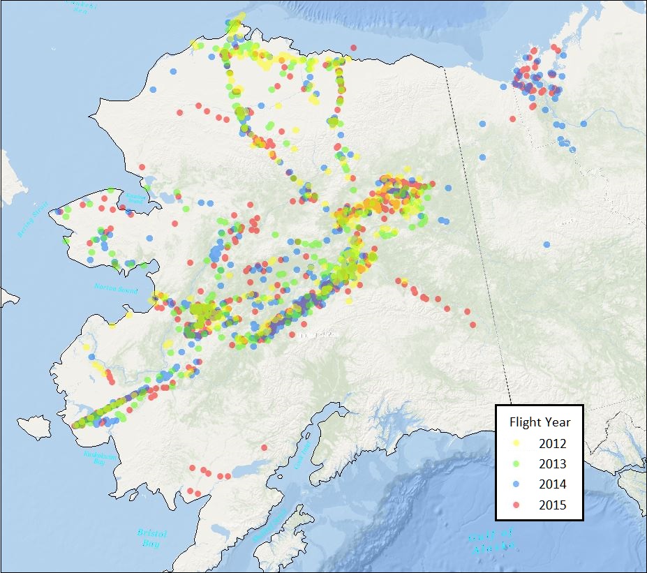
-
Methane flux from closed chamber with spectrometer across two thermokarst lake ecosystems, 2018, Interior Alaska (US)
This dataset provides diffusive methane (CH4) fluxes collected from two thermokarst lakes in the Goldstream Valley, north of Fairbanks in interior Alaska. Fluxes were collected...
-
Methane Fluxes from Shorelines and Differing Surfaces, 2019, Big Trail Lake, Alaska (US)
This dataset provides methane fluxes from hot-spot and non-hot spot differing surfaces at Big Trail Lake (BTL) in the Goldstream Valley near Fairbanks, AK, USA. Measurements...
-
The fractional land cover estimates from the Boreal–Arctic Wetland and Lake Dataset (BAWLD), 2021, Circum-Arctic
The Boreal and Arctic Wetland and Lake Dataset (BAWLD) provides estimates of fractional land cover of 19 land cover classes within 0.5° ×0.5° grid cells. The total area of the...
-
Hyperspectral Imagery AVIRIS-NG V2, 2017-2019, Alaskan and Canadian Arctic
This dataset provides Level 1 radiance and Level 2 surface reflectance measured by the Airborne Visible/Infrared Imaging Spectrometer-Next Generation (AVIRIS-NG) instrument...
