-
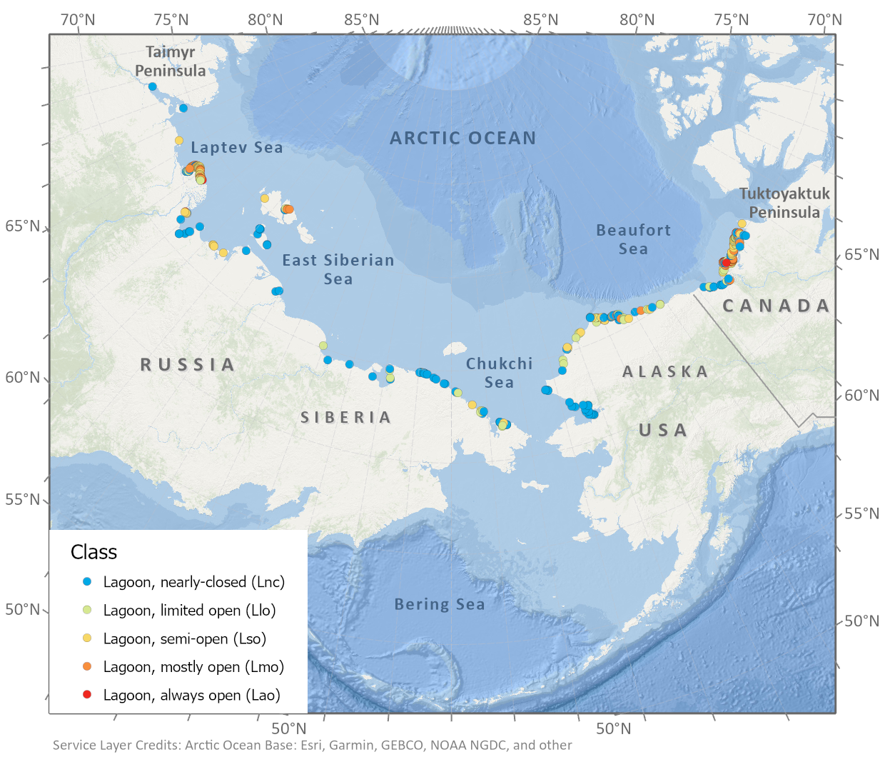
Pan-Arctic thermokarst lagoon distribution, area and classification from Landsat images, 1984 to 2021
Thermokarst lagoons develop in permafrost lowlands along the ice-rich Arctic coast when thermokarst lakes or basins with bottom elevations at or below sea level are breached by... -
Spatial lake dynamics and lake-ice datasets of the Northern Seward and Baldwin Peninsulas in Alaska
The data publication contains supplementary data to the article "Supplementary Dataset to: The catastrophic thermokarst lake drainage events of 2018 in northwestern Alaska:... -
Pan-Arctic Visualization of Landscape Change (2003-2022), Arctic PASSION Permafrost Service
This raster dataset, in Cloud Optimized GeoTIFF format (COG), provides information on land surface changes at the pan-arctic scale. Multispectral Landsat-5 TM, Landsat-7 ETM+,... -
Surface Soil Moisture from ENVISAT ASAR GM, 2005-2010, Laptev Sea Coast, Laptev and East Siberian Sea Region (RU)
The SAR Surface Soil Moisture (SSM) product is derived from the ENVISAT ASAR sensor operating in Global Monitoring (GM) mode. The SAR SSM product is a weekly mean composite at 1... -
Surface Soil Moisture from ENVISAT ASAR GM, 2005-2011, Mackenzie River Valley and Delta, Beaufort Sea Region (CA)
The SAR Surface Soil Moisture (SSM) product is derived from the ENVISAT ASAR sensor operating in Global Monitoring (GM) mode. The SAR SSM product is a weekly mean composite at 1... -
Surface Soil Moisture from ENVISAT ASAR GM, 2005-2011, Ob Estuary and Yamal Peninsula, Western Siberia (RU)
The SAR Surface Soil Moisture (SSM) product is derived from the ENVISAT ASAR sensor operating in Global Monitoring (GM) mode. The SAR SSM product is a weekly mean composite at 1... -
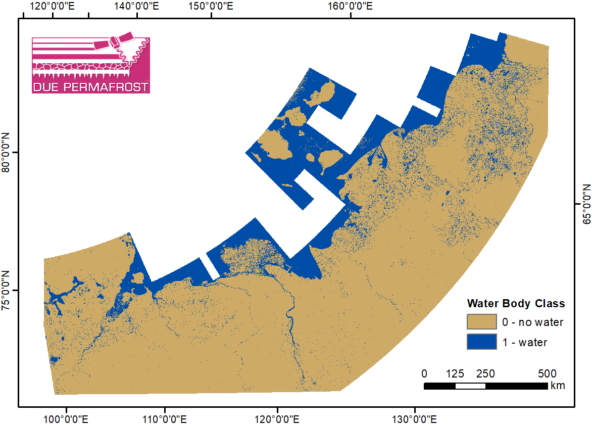
Water Body Classification from ENVISAT ASAR Wide Swath, 2007-2011, Lena Delta / East Taymir / Cherskii, Laptev and Ea...
The regional waterbody classification is derived from ENVISAT ASAR Wide Swath data with 150 m resolution. Maps represent the extent of water bodies for the summer months July... -
Water Body Classification from ENVISAT ASAR Wide Swath, 2007-2011, Ob Estuary and Yamal Peninsula, Western Siberia (RU)
The regional waterbody classification is derived from ENVISAT ASAR Wide Swath data with 150 m resolution. Maps represent the extent of water bodies for the summer months July... -
Surface Soil Moisture from ENVISAT ASAR GM, 2005-2011, Yakutsk, Central Yakutia (RU)
The SAR Surface Soil Moisture (SSM) product is derived from the ENVISAT ASAR sensor operating in Global Monitoring (GM) mode. The SAR SSM product is a weekly mean composite at 1... -
Water Body Classification from ENVISAT ASAR Wide Swath, 2007-2008, Yakutsk, Central Yakutia (RU)
The regional waterbody classification is derived from ENVISAT ASAR Wide Swath data with 150 m resolution. Maps represent the extent of water bodies for the summer months July... -
Water Body Classification from ENVISAT ASAR Wide Swath, 2007-2011, Mackenzie River Valley and Delta, Beaufort Sea Reg...
The regional waterbody classification is derived from ENVISAT ASAR Wide Swath data with 150 m resolution. Maps represent the extent of water bodies for the summer months July... -
Inorganic and organic hydrochemistry of lakes and ponds in continuous permafrost landscapes in the western Canadian A...
Between 2006 and 2015 inorganic and organic hydrochemical parameters and stable water isotope characteristics were measured in lakes and ponds in continuous permafrost... -
Fluorescent dissolved organic matter (FDOM) intensity (Parafac components and FDOM indices) in the surface water duri...
Fluorescent dissolved organic matter intensity was measured with an Aqualog®. Measurements were corrected for inner-filter effects and for the Raman and Rayleigh scattering... -
Remote sensing reflectance (Rrs) of the surface water during 4 expeditions from spring to fall in 2019, Mackenzie Del...
Vertical profiles of downwelling irradiance (Ed) and upwelling radiance (Lu) were measured during legs 2, 3, and 4 using a Compact-Optical Profiling System (C-OPS) in an ICE-Pro... -
Particle absorption (aP) in the surface water during 4 expeditions from spring to fall in 2019, Mackenzie Delta Regio...
Absorbance of particles retained on GF/F (0.7 µm) filters was measured using a Varian Cary 100 spectrophotometer equipped with an integrated sphere. Absorbance and reflectance... -
Phytoplankton pigment concentrations measured by HPLC in the surface water during 4 expeditions from spring to fall i...
The determination of phytoplankton using high performance liquid chromatography (HPLC) is detailed in Hooker et al. (2005; doi:10.1364/AO.44.000553) and Ras et al. (2008;... -
Colored dissolved organic matter absorption (aCDOM) and spectal slopes (S) in the surface water during 4 expeditions ...
Measurement of CDOM absorption was conducted from a water sample within 12 hours of collection using an UltraPath liquid waveguide system (World Precision Instruments, Inc.)... -
Temperature and salinity in the surface water during 4 expeditions from spring to fall in 2019, Mackenzie Delta Regio...
During Leg 1, the CTD (CTD RBR Maestro) was manually lowered in the water through an ice hole. During legs 2 to 4, the CTD (CTD RBR Concerto) was installed on a Seabird... -
Hydrographic (CTD) profiles during 4 expeditions from spring to fall in 2019, Mackenzie Delta Region (CA)
During Leg 1, the CTD (CTD RBR Maestro) was manually lowered in the water through an ice hole with a velocity of less than 0.3 ms-1 and an acquisition frequency of 6 Hz,... -
Land Cover Classification from Sentinel-1 and Sentinel-2, 2015-2018, Mackenzie Delta, Beaufort Sea Region (CA)
Land cover classes have been derived from bands of Sentinel-2 (bands 3 (green, 10m), 4 (red, 10m), 8 (near infrared, 10m), 11 (SWIR, 20m) and 12 (SWIR, 20m)) as well as...


