-
Growing season, non-growing season and annual CH4 fluxes from temperate, boreal, and Arctic wetlands and uplands,...
Wetlands are the single largest natural source of atmospheric methane (CH4), a greenhouse gas, and occur extensively in the northern hemisphere. Large discrepancies remain...
-
Permafrost Extent and Ground Temperature Map, 2000-2016, Northern Hemisphere Permafrost
The product provides modeled mean annual ground temperatures (MAGT) at the top of the permafrost for the Northern Hemisphere at 1 km spatial resolution. Permafrost probability...
-
The Wetland and Wetland CH4 Inter-comparison of Models Project (WETCHIMP) data archive
This archive contains the raw and post-processed model output used in the The Wetland and Wetland CH4 Inter-comparison of Models Project (WETCHIMP). There are top-level...
-
Point Pedon Data of the Northern Circumpolar Soil Carbon Database, Circum-Arctic
The Northern Circumpolar Soil Carbon Database version 2 (NCSCDv2) is a geospatial database created for the purpose of quantifying storage of organic carbon in soils of the...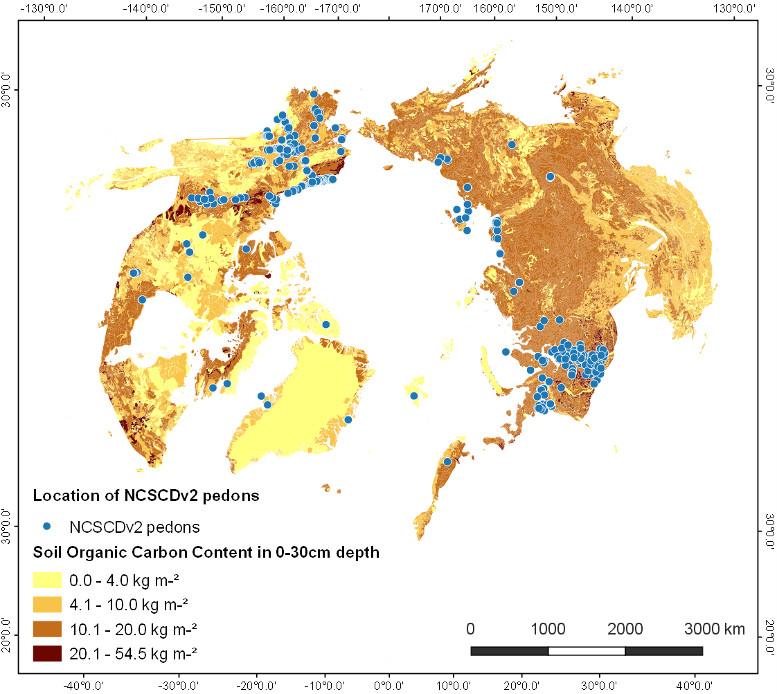
-
Lake Ice Classification from Sentinel-1, 2015-2016, Teshekpuk, Alaska (US)
Weekly lake ice classifications distinguish grounded ice and floating ice in lakes based on Sentinel-1A and Sentinel-1B synthetic aperture radar time-series with a resolution of...
-
Vegetation Height from Sentinel-1 and Sentinel-2, Kytalyk, 2016-2018, Central Yakutia (RU)
Vegetation height has been derived from Sentinel-1 satellite data acquired in VV mode with a resolution of 20 m. Vegetation height was estimated using an empirical model on...
-
Rockglacier and Slope Instability Inventory from differential SAR interferograms and optical imagery, 1998-2016,...
Rockglaciers and other periglacial processes were mapped using visual analysis of differential SAR interferograms and satellite optical images (Google Satellite, Bing Aerial)...
-
Lake Ice Classification from Sentinel-1, 2016-2017, Central Seward Peninsula, Alaska (US)
Lake ice classifications distinguish grounded ice and floating ice in lakes based on Sentinel-1A and Sentinel-1B synthetic aperture radar time-series with a resolution between...
-
Lake Ice Classification from Sentinel-1, 2016-2017, Cape Espenberg Lowland, Alaska (US)
Lake ice classifications distinguish grounded ice and floating ice in lakes based on Sentinel-1A and Sentinel-1B synthetic aperture radar time-series with a resolution between...
-
Vegetation Height from Sentinel-1 and Sentinel-2, 2016-2018, Teshekpuk, Arctic Alaska (US)
Vegetation height has been derived from Sentinel-1 satellite data acquired in VV mode with a resolution of 20 m. Vegetation height was estimated using an empirical model on...
-
Footprints of MACS aerial images from POLAR 6 ThawTrend_Air_2019 flight campaign in northern Alaska (US)
This datasets contains the footprints of the DLR MACS (Modular Aerial Camera System) acquisitions (RGB + NIR) during the AWI ThawTrendAir2019 campaign on POLAR 6 from 10 July...
-
Vegetation Height from Sentinel-1 and Sentinel-2, 2015-2018, Seward peninsula, Alaska (US)
Vegetation height has been derived from Sentinel-1 satellite data acquired in VV mode with a resolution of 20 m. Vegetation height was estimated using an empirical model on...
-
Vegetation Height from Sentinel1 and Sentinel-2, 2016-2018, Barrow, Alaska (US)
Vegetation height has been derived from Sentinel-1 satellite data acquired in VV mode with a resolution of 20 m. Vegetation height was estimated using an empirical model on...
-
Vegetation Height from Sentinel-1 and Sentinel-2, 2016-2018, Toolik, Alaska (US)
Vegetation height has been derived from Sentinel-1 satellite data acquired in VV mode with a resolution of 20 m. Vegetation height was estimated using an empirical model on...
-
Vegetation Height from Sentinel-1 and Sentinel-2, 2016-2018, Mackenzie Delta, Beaufort Sea Region (CA)
Vegetation height has been derived from Sentinel-1 satellite data acquired in VV mode with a resolution of 20 m. Vegetation height was estimated using an empirical model on...
-
Vegetation Height from Sentinel-1 and Sentinel-2, 2016-2018, Umiuaq, Quebec-Labrador (CA)
Vegetation height has been derived from Sentinel-1 satellite data acquired in VV mode with a resolution of 20 m. Vegetation height was estimated using an empirical model on...
-
Vegetation Height from Sentinel-1 and Sentinel-2, 2016-2018, Lena Delta, Laptev and East Siberian Sea Region (RU)
Vegetation height has been derived from Sentinel-1 satellite data acquired in VV mode with a resolution of 20 m. Vegetation height was estimated using an empirical model on...
-
Vegetation Height from Sentinel-1 and Sentinel-2, 2016-2018, Western Siberia (RU)
Vegetation height has been derived from Sentinel-1 satellite data acquired in VV mode with a resolution of 20 m. Vegetation height was estimated using an empirical model on...
-
Mapped thermokarst ice wedge polygon patterns from GeoEye-1, 2009, Buor Khaya, Laptev Sea coast, Siberia (RU)
Detailed calculations of ground-ice volumes in permafrost deposits are necessary to understand and quantify the response of permafrost landscapes to thermal disturbance and...
-
Surface Water Area from sub-meter resolution Satellite Imagery, 2002-2019, Kotzebue, Northwestern Baldwin Peninsula...
Arctic landscapes are in a state of transition due to changes in climate occurring during both the summer and winter seasons. Scattered observations indicate that beavers...
Šį registrą taip pat galite pasiekti pasinaudodami API (žiūrėkite API dokumentacija).