-
Permafrost extent for the Northern Hemisphere, v3.0 from MODIS LST, ERA5, 1997-2019
This dataset contains permafrost extent data produced as part of the European Space Agency's (ESA) Climate Change Initiative (CCI) Permafrost project. It forms part of the...
-
Permafrost ground temperature for the Northern Hemisphere, v3.0 from MODIS LST, ERA5, 1997-2019
This dataset contains permafrost ground temperature data produced as part of the European Space Agency's (ESA) Climate Change Initiative (CCI) Permafrost project. It forms part...
-
Growing season, non-growing season and annual CH4 fluxes from temperate, boreal, and Arctic wetlands and uplands,...
Wetlands are the single largest natural source of atmospheric methane (CH4), a greenhouse gas, and occur extensively in the northern hemisphere. Large discrepancies remain...
-
Cumulative greenhouse gas production in thawed sediments, 2019-2020, Yukechi Alas, Central Yakutia (RU)
This dataset describes two 17 m long sediment cores taken from beneath two thermokarst lakes in the Yukechi Alas, Central Yakutia, Russia. The first core was taken from below an...
-
Permafrost Extent and Ground Temperature Map, 2000-2016, Northern Hemisphere Permafrost
The product provides modeled mean annual ground temperatures (MAGT) at the top of the permafrost for the Northern Hemisphere at 1 km spatial resolution. Permafrost probability...
-
The Wetland and Wetland CH4 Inter-comparison of Models Project (WETCHIMP) data archive
This archive contains the raw and post-processed model output used in the The Wetland and Wetland CH4 Inter-comparison of Models Project (WETCHIMP). There are top-level...
-
TCCON data from Ny-Ålesund, Svalbard (NO), Release GGG2020.R0
The Total Carbon Column Observing Network (TCCON) is a network of ground-based Fourier Transform Spectrometers that record direct solar absorption spectra of the atmosphere in... -
In-situ Carbon and CH4 Flux and Meteorology at EC Towers, Atqasuk, Barrow, Ivotuk, Alaska, 2011-2015
This data set provides ground in situ flux and meteorological science data from fixed instruments at three eddy covariance tower sites located in the Alaskan Arctic tundra. Real...
-
Global Methane Budget 2000-2017
The Global Carbon Project (GCP) publishes an up-date of the global methane (CH4) sources and sinks to the atmosphere. This budget show that global methane emissions have...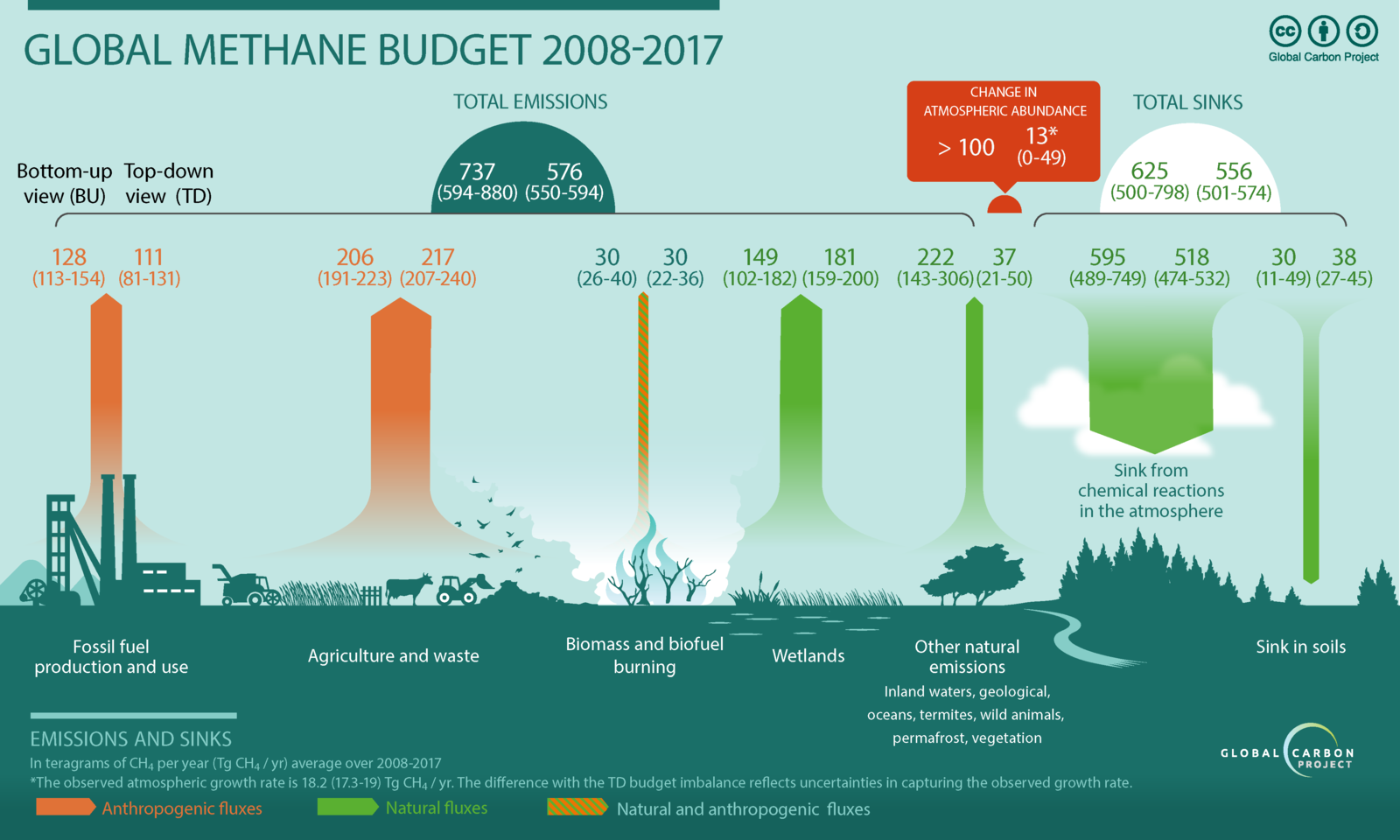
-
Land Cover Classification from Sentinel-1 and Sentinel-2, 2015-2018, Western Siberia (RU)
Land cover classes have been derived from bands of Sentinel-2 (bands 3 (green, 10m), 4 (red, 10m), 8 (near infrared, 10m), 11 (SWIR, 20m) and 12 (SWIR, 20m)) as well as...
-
Land Cover Classification from Sentinel-1 and Sentinel-2, 2015-2018, Yukon Delta, Alaska (US)
Land cover classes have been derived from bands of Sentinel-2 (bands 3 (green, 10m), 4 (red, 10m), 8 (near infrared, 10m), 11 (SWIR, 20m) and 12 (SWIR, 20m)) as well as...
-
Land Cover Classification from Sentinel-1 and Sentinel-2, 2015-2018, Seward Peninsula, Alaska (US)
Land cover classes have been derived from bands of Sentinel-2 (bands 3 (green, 10m), 4 (red, 10m), 8 (near infrared, 10m), 11 (SWIR, 20m) and 12 (SWIR, 20m)) as well as...
-
Land Cover Classification from Sentinel-1 and Sentinel-2, 2015-2018, Lena Delta, Laptev and East Siberian Sea Region (RU)
Land cover classes have been derived from bands of Sentinel-2 (bands 3 (green, 10m), 4 (red, 10m), 8 (near infrared, 10m), 11 (SWIR, 20m) and 12 (SWIR, 20m)) as well as...
-
Land Cover Classification from Sentinel-1 and Sentinel-2, 2015-2018, Kytalyk, Central Yakutia (RU)
Land cover classes have been derived from bands of Sentinel-2 (bands 3 (green, 10m), 4 (red, 10m), 8 (near infrared, 10m), 11 (SWIR, 20m) and 12 (SWIR, 20m)) as well as...
-
Land Cover Classification from Sentinel-1 and Sentinel-2, 2015-2018, Umiaq, Canadian (Arctic) Archipelago (CA)
Land cover classes have been derived from bands of Sentinel-2 (bands 3 (green, 10m), 4 (red, 10m), 8 (near infrared, 10m), 11 (SWIR, 20m) and 12 (SWIR, 20m)) as well as...
-
Land Cover Classification from Sentinel-1 and Sentinel-2, 2015-2018, Teshekpuk, Alaska (US)
Land cover classes have been derived from bands of Sentinel-2 (bands 3 (green, 10m), 4 (red, 10m), 8 (near infrared, 10m), 11 (SWIR, 20m) and 12 (SWIR, 20m)) as well as...
-
Land Cover Classification from Sentinel-1 and Sentinel-2, 2015-2018, Barrow, Alaska (US)
Land cover classes have been derived from bands of Sentinel-2 (bands 3 (green, 10m), 4 (red, 10m), 8 (near infrared, 10m), 11 (SWIR, 20m) and 12 (SWIR, 20m)) as well as...
-
Land Surface Feature Classification from TerraSAR-X, 2016, Hershel Island, Beaufort Sea Region (CA)
Land surface features (water, wetland, tundra, and bare surfaces) were classified from TerraSAR-X with a resolution of 5 m for August 2016. The product is based on the...
-
Land Surface Feature Classification from TerraSAR-X, 2016, Vaskiny Dachi, Western Siberia (RU)
Land surface features (water, wetland, tundra, and bare surfaces) were classified from TerraSAR-X with a resolution of 5 m for August 2016. The product is based on the...
-
Land Surface Feature Classification from TerraSAR-X, 2013, Kytalyk, Central Yakutia (RU)
Land surface features (water, wetland, tundra, and bare surfaces) were classified from TerraSAR-X with a resolution of 5 m for July 2013. The product is based on the...