-
Soil and incubation data of permafrost-affected soils in Samoylov, 2011 & 2013
The effects of oxygen availability, freezing and thawing, temperature, and labile organic matter (OM) additions on greenhouse gas production were studied in northeast Siberian...
-
Methane production in laboratory incubations of Arctic soil, Utqiaġvik, Alaska, 2018
When wet Arctic tundra soils begin to freeze in the fall, an unfrozen layer remains between the frozen surface and deeper permafrost layers. This period is known as the zero...
-
Laboratory soil incubation respiration rates from permafrost in subarctic Canada, 2013 & 2014
This dataset contains measures of laboratory soil incubation respiration rates from permafrost in subarctic Canada. Soil cores were sampled from a peatland plateau and a thawing...
-
Greenhouse gas production and soil chemistry in soil Incubations after nitrogen addition, Seward Peninsula, 2018-2019
This dataset provides the results of laboratory soil microcosm incubation experiments conducted under anaerobic conditions with and without the addition of ammonium chloride...
-
Methane fluxes from burnt and unburnt forests from permafrost in subarctic Canada, 2013 & 2014
This dataset contains methane fluxes from peatland plateaus and thawing peatland plateaus and from burnt and unburnt forests from permafrost in subarctic Canada. Methane fluxes...
-
Soil respired radiocarbon as CO2 and CH4 from permafrost in subarctic Canada, 2013 & 2014
This dataset contains measures of soil respired radiocarbon as CO2 and CH4 from peatland plateaus and thawing peatland plateaus and from burnt and unburnt forests from...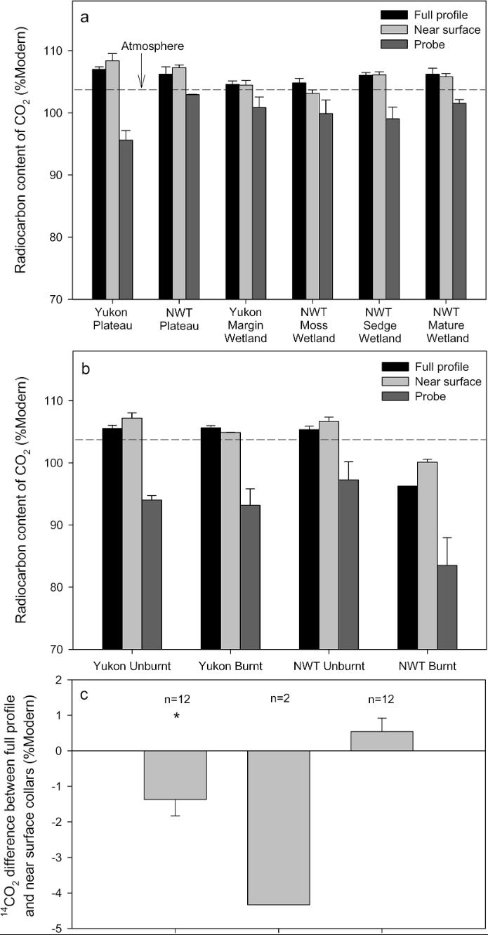
-
Geochemistry of incubated permafrost and seawater from the western Canadian Arctic
We present geochemical and hydrochemical information on individual permafrost and seawater samples from the Yukon Coast in the western Canadian Arctic used for an incubation...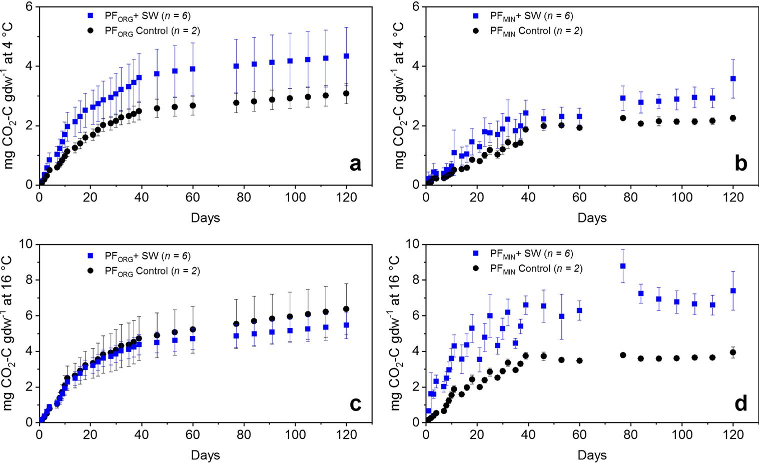
-
Anaerobic incubation measurements (CH4+CO2) and microbe quantification, Lena Delta, 2018
The data sets were made during the summer 2021, with samples collected from three cores, at two depths (active and permafrost layers). In total, six samples (3 replicates by...
-
ABoVE: Methane Ebullition Hotspots in Frozen Lakes near Fairbanks, Alaska, Oct 2014
This dataset includes maps of the locations and number of methane ebullition hotspots in 15 frozen lakes in the southern portion of the Goldstream Valley and the surrounding...
-
TCCON data from Sodankylä, Lapland (FI), Release GGG2020.R0
The Total Carbon Column Observing Network (TCCON) is a network of ground-based Fourier Transform Spectrometers that record direct solar absorption spectra of the atmosphere in... -
UAV-based methane data from Barter Island, September 2017, Barrow, 1986-2017, Alaska (US)
Arctic permafrost stores vast amounts of methane (CH4) in subsurface reservoirs. Thawing permafrost creates areas for this potent greenhouse gas to be released to the...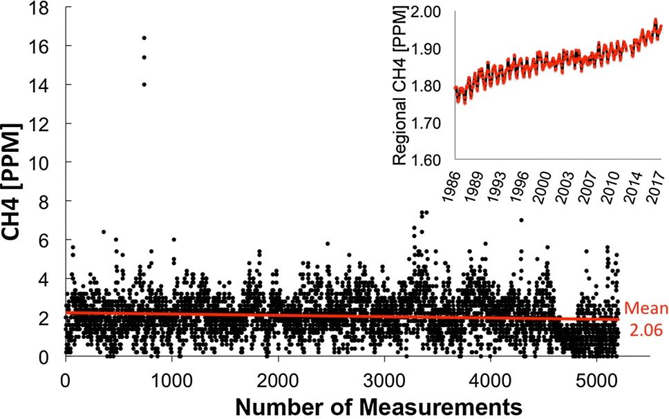
-
Radiocarbon content of CO2, CH4, DOC and particulate organic carbon from the northern permafrost region
The dataset includes 14C measurements of CO2, CH4, DOC and POC mostly from the northern permafrost region. Some other studies are included from sites not underlained by...
-
Global SCIAMACHY and GOSAT Level 3 gridded atmospheric column-average methane (XCH4) product in Obs4MIPs format, 2003-2014
This dataset contains satellite-derived atmospheric column-average dry-air mole fractions of methane (XCH4), and is a Level 3 gridded product in Obs4MIPs format. It has been...
-
Land Cover Classification from Sentinel-1 and Sentinel-2, 2015-2018, Mackenzie Delta, Beaufort Sea Region (CA)
Land cover classes have been derived from bands of Sentinel-2 (bands 3 (green, 10m), 4 (red, 10m), 8 (near infrared, 10m), 11 (SWIR, 20m) and 12 (SWIR, 20m)) as well as...
-
Isotopic composition of ground ice, ebullition gases and thermokarst lake water, Alaska, 2008-2010
Thermokarst lakes are thought to have been an important source of methane (CH4) during the last deglaciation when atmospheric CH4 concentrations increased rapidly. Here we...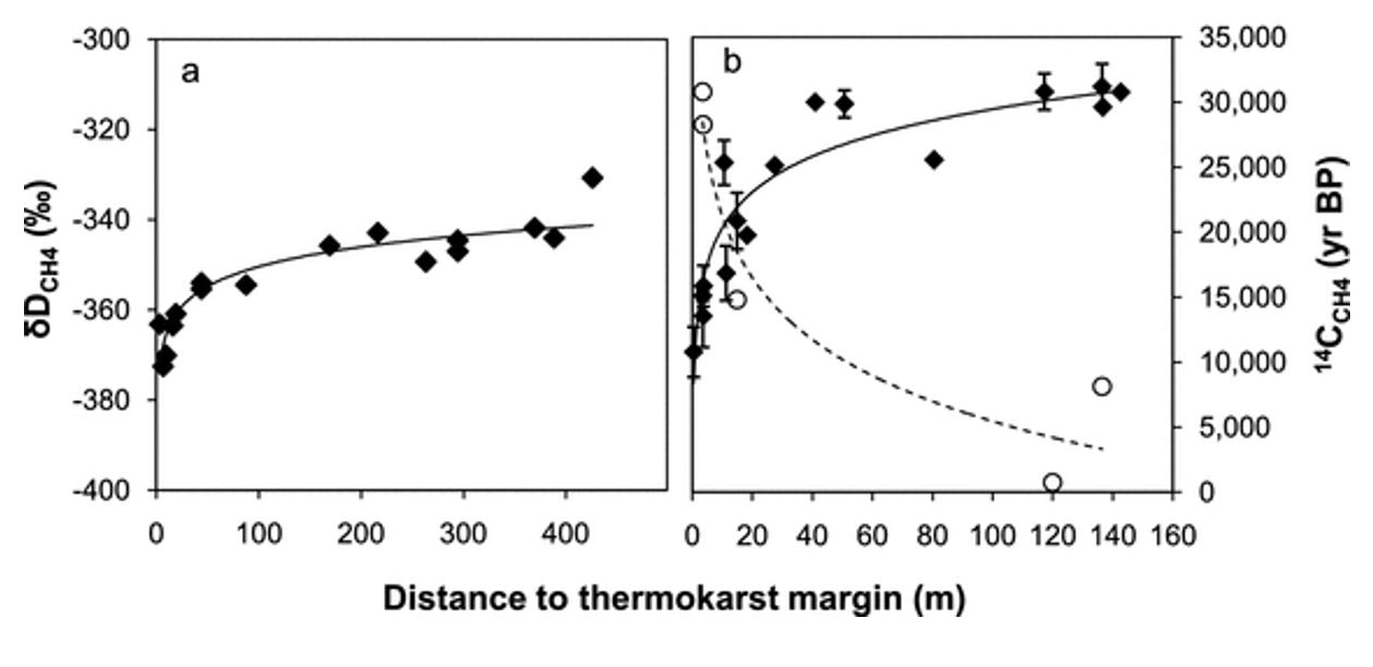
-
GHG data from inverse models and UNFCCC national inventories, Global, 1990-2019
Anthropogenic greenhouse gas (carbon dioxide, methane, nitrous oxide) data from inverse models and UNFCCC national inventories This dataset contains 5 datasets, including GHG...
-
Methane and nitrous oxide dissolved gas concentrations in seawater from the North American Arctic Ocean (2015–2018)
This dataset contains methane and nitrous oxide dissolved gas concentration, dissolved methane carbon isotope, and ancillary hydrographic data from research cruises in the North...
-
Methane and nitrous oxide dissolved gas concentrations from rivers in the North American Arctic (2017–2019)
This dataset contains methane and nitrous oxide dissolved gas concentration and dissolved methane carbon isotope data from rivers in the Canadian Arctic Archipelago region...
-
PEATMAP - peatland distribution maps based on meta-analysis, 1999-2010, Global
PEATMAP is a GIS shapefile dataset that shows a distribution of peatlands that covers the entire world. It was produced by combining the most high quality available peatland map...
-
CO2 and CH4 Production in Soil Incubations from Low and High Centered Polygons, Barrow, Alaska, 2012-2013
The dataset consists of respiration and methane production rates obtained from soil microcosm studies carried out under controlled temperature and incubation conditions. Soils...