-
Super-high-resolution aerial imagery, digital surface model and 3D point cloud of Cape Simpson, Alaska (subset 03)
As part of the ThawTrend-Air airborne campaign led by the Alfred Wegener Institute in 2019, we collected super-high-resolution multispectral imagery of permafrost landscapes...
-
Super-high-resolution aerial imagery, digital surface model and 3D point cloud of Cape Simpson, Alaska (subset 02)
As part of the ThawTrend-Air airborne campaign led by the Alfred Wegener Institute in 2019, we collected super-high-resolution multispectral imagery of permafrost landscapes...
-
Super-high-resolution aerial imagery, digital surface model and 3D point cloud of Cape Simpson, Alaska (subset 01)
As part of the ThawTrend-Air airborne campaign led by the Alfred Wegener Institute in 2019, we collected super-high-resolution multispectral imagery of permafrost landscapes...
-
Super-high-resolution aerial imagery, digital surface model and 3D point cloud of Chamisso Island, Alaska
As part of the Perma-X airborne campaign led by the Alfred Wegener Institute in 2021, we collected super-high-resolution multispectral imagery of permafrost landscapes with the...
-
Super-high-resolution aerial imagery, digital surface model and 3D point cloud of Herschel Island, Canada
As part of the MOSES airborne campaign led by the Alfred Wegener Institute in 2018, we collected super-high-resolution multispectral imagery of permafrost landscapes with the...
-
Super-high-resolution aerial imagery, digital surface model and 3D point cloud of Inuvik-Tuktoyaktuk-Highway, Canada
As part of the MOSES airborne campaign led by the Alfred Wegener Institute in 2018, we collected super-high-resolution multispectral imagery of permafrost landscapes with the...
-
Super-high-resolution aerial imagery, digital surface model and 3D point cloud of Kivalina, Alaska
As part of the Perma-X airborne campaign led by the Alfred Wegener Institute in 2021, we collected super-high-resolution multispectral imagery of permafrost landscapes with the...
-
Super-high-resolution aerial imagery, digital surface model and 3D point cloud of Kotzebue, Alaska
As part of the Perma-X airborne campaign led by the Alfred Wegener Institute in 2021, we collected super-high-resolution multispectral imagery of permafrost landscapes with the...
-
Super-high-resolution aerial imagery, digital surface model and 3D point cloud of Lake Basins on the Northern Seward...
As part of the Perma-X airborne campaign led by the Alfred Wegener Institute in 2021, we collected super-high-resolution multispectral imagery of permafrost landscapes with the...
-
Super-high-resolution aerial imagery, digital surface model and 3D point cloud of Selawik Village, Alaska
As part of the Perma-X airborne campaign led by the Alfred Wegener Institute in 2021, we collected super-high-resolution multispectral imagery of permafrost landscapes with the...
-
Super-high-resolution aerial imagery, digital surface model and 3D point cloud of Shishmaref, Alaska
As part of the Perma-X airborne campaign led by the Alfred Wegener Institute in 2021, we collected super-high-resolution multispectral imagery of permafrost landscapes with the...
-
Super-high-resolution aerial imagery, digital surface model and 3D point cloud of Shungnak and Kobuk Villages, Alaska
As part of the Perma-X airborne campaign led by the Alfred Wegener Institute in 2021, we collected super-high-resolution multispectral imagery of permafrost landscapes with the...
-
Super-high-resolution aerial imagery, digital surface model and 3D point cloud of the Ikpikpuk Delta, Alaska
As part of the ThawTrend-Air airborne campaign led by the Alfred Wegener Institute in 2019, we collected super-high-resolution multispectral imagery of permafrost landscapes...
-
Super-high-resolution aerial imagery, digital surface model and 3D point cloud of the Noatak Coast, Alaska
As part of the Perma-X airborne campaign led by the Alfred Wegener Institute in 2021, we collected super-high-resolution multispectral imagery of permafrost landscapes with the...
-
Super-high-resolution aerial imagery, digital surface model and 3D point cloud of the Noatak River Slump, Alaska
As part of the Perma-X airborne campaign led by the Alfred Wegener Institute in 2021, we collected super-high-resolution multispectral imagery of permafrost landscapes with the...
-
Super-high-resolution aerial imagery, digital surface model and 3D point cloud of the Northern Baldwin Peninsula, Alaska
As part of the Perma-X airborne campaign led by the Alfred Wegener Institute in 2021, we collected super-high-resolution multispectral imagery of permafrost landscapes with the...
-
Super-high-resolution aerial imagery, digital surface model and 3D point cloud of the Selawik Thaw Slump, Alaska
As part of the Perma-X airborne campaign led by the Alfred Wegener Institute in 2021, we collected super-high-resolution multispectral imagery of permafrost landscapes with the...
-
Super-high-resolution aerial imagery, digital surface model and 3D point cloud of the Southern Noatak River, Alaska
As part of the Perma-X airborne campaign led by the Alfred Wegener Institute in 2021, we collected super-high-resolution multispectral imagery of permafrost landscapes with the...
-
Content of carbon isotopes (¹³C and ¹⁴C) in organic carbon pools in terrestrial Siberia
The dataset consists of one xlsx file with four sheets, listing (1) ¹³C and ¹⁴C data of litter and organic layers in northern Russia, Scandinavia, Canada and Alaska; (2) ¹³C and...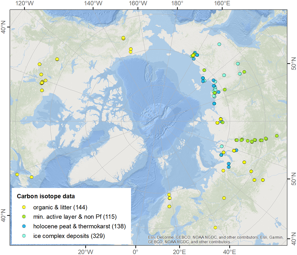
-
Polygonal Tundra Geomorphology Map from Landsat time series, 2014, Alaskan Arctic Coastal Plain (US)
We mosaicked twelve LandSat-8 OLI satellite images taken during the summer of 2014, which were used in an object based image analysis (OBIA) to classify the landscape. We mapped...
You can also access this registry using the API (see Dokumentasi API).