-
ALLena: Thaw depth measurements of the active layer in the Lena River Delta region from 1998 to 2022, Northeastern...
Active layer thickness (ALT) is one of currently two Essential Climate Variables related directly to permafrost regions as defined by the Global Climate Observing System (GCOS)...
-
ALLena: Thaw depth measurements of the active layer in the Lena River Delta region from 1998 to 2022, Northeastern...
Active layer thickness (ALT) is one of currently two Essential Climate Variables related directly to permafrost regions as defined by the Global Climate Observing System (GCOS)...
-
ALLena: Thaw depth measurements of the active layer in the Lena River Delta region from 1998 to 2022, Northeastern...
Active layer thickness (ALT) is one of currently two Essential Climate Variables related directly to permafrost regions as defined by the Global Climate Observing System (GCOS)...
-
ALLena: Thaw depth measurements of the active layer in the Lena River Delta region from 1998 to 2022, Northeastern...
Active layer thickness (ALT) is one of currently two Essential Climate Variables related directly to permafrost regions as defined by the Global Climate Observing System (GCOS)...
-
ALLena: Thaw depth measurements of the active layer in the Lena River Delta region from 1998 to 2022, Northeastern...
Active layer thickness (ALT) is one of currently two Essential Climate Variables related directly to permafrost regions as defined by the Global Climate Observing System (GCOS)...
-
ALLena: Thaw depth measurements of the active layer in the Lena River Delta region from 1998 to 2022, Northeastern...
Active layer thickness (ALT) is one of currently two Essential Climate Variables related directly to permafrost regions as defined by the Global Climate Observing System (GCOS)...
-
ALLena: Thaw depth measurements of the active layer in the Lena River Delta region from 1998 to 2022, Northeastern...
Active layer thickness (ALT) is one of currently two Essential Climate Variables related directly to permafrost regions as defined by the Global Climate Observing System (GCOS)...
-
ALLena: Thaw depth measurements of the active layer in the Lena River Delta region from 1998 to 2022, Northeastern...
Active layer thickness (ALT) is one of currently two Essential Climate Variables related directly to permafrost regions as defined by the Global Climate Observing System (GCOS)...
-
ALLena: Thaw depth measurements of the active layer in the Lena River Delta region from 1998 to 2022, Northeastern...
Active layer thickness (ALT) is one of currently two Essential Climate Variables related directly to permafrost regions as defined by the Global Climate Observing System (GCOS)...
-
ALLena: Thaw depth measurements of the active layer in the Lena River Delta region from 1998 to 2022, Northeastern...
Active layer thickness (ALT) is one of currently two Essential Climate Variables related directly to permafrost regions as defined by the Global Climate Observing System (GCOS)...
-
ALLena: Thaw depth measurements of the active layer in the Lena River Delta region from 1998 to 2022, Northeastern Siberia
Active layer thickness (ALT) is one of currently two Essential Climate Variables related directly to permafrost regions as defined by the Global Climate Observing System (GCOS)...
-
Database of Ice-Rich Yedoma Permafrost (IRYP)
We synthesized data on the circum-Arctic and sub-Arctic distribution and thickness of Yedoma for compiling a preliminary circum-polar Yedoma map. For compiling this map, we used...
-
Database of Ice-Rich Yedoma Permafrost Version 2 (IRYP v2)
Ice-rich permafrost in the circum-Arctic and sub-Arctic, such as late Pleistocene Yedoma, are especially prone to degradation due to climate change or human activity. When...
-
DARTS: Multi-year database of AI detected retrogressive thaw slumps (RTS) in hotspots of the circum-arctic...
This dataset, called DARTS, comprises footprints of active parts of retrogressive thaw slump (RTS) identified and quantified using an automated deep learning approach in RTS...
-
40-year monthly mean AVHRR GAC Land Surface Temperature data for the Pan-Arctic region (Pan-Arctic AVHRR LST)
This data collection contains 40 years of monthly mean daytime AVHRR Global Area Coverage (GAC) land surface temperature (LST) data. This dataset covers the 1981-2020 perdiod...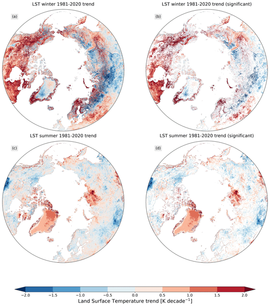
-
DARTS: Multi-year database of AI detected retrogressive thaw slumps (RTS) and active layer detachment slides (ALD)...
This dataset, called DARTS, comprises footprints of retrogressive thaw slump (RTS) and active layer detachments slides (ALD) identified and quantified using an automated deep... -
Super-high-resolution aerial imagery, digital surface model and 3D point cloud of Cape Blossom, Alaska (7 cm)
As part of the Perma-X airborne campaign led by the Alfred Wegener Institute in 2021, we collected super-high-resolution multispectral imagery of permafrost landscapes with the...
-
Super-high-resolution aerial imagery, digital surface model and 3D point cloud of Cape Blossom, Alaska (10 cm)
As part of the Perma-X airborne campaign led by the Alfred Wegener Institute in 2021, we collected super-high-resolution multispectral imagery of permafrost landscapes with the...
-
Super-high-resolution aerial imagery, digital surface model and 3D point cloud of Cape Blossom, Alaska (20 cm)
As part of the Perma-X airborne campaign led by the Alfred Wegener Institute in 2021, we collected super-high-resolution multispectral imagery of permafrost landscapes with the...
-
Super-high-resolution aerial imagery, digital surface model and 3D point cloud of Trail Valley Creek, Canada (subset 08)
As part of the MOSES airborne campaign led by the Alfred Wegener Institute in 2018, we collected super-high-resolution multispectral imagery of permafrost landscapes with the...
You can also access this registry using the API (see Dokumentasi API).