-
ALLena: Thaw depth measurements of the active layer in the Lena River Delta region from 1998 to 2022, Northeastern...
Active layer thickness (ALT) is one of currently two Essential Climate Variables related directly to permafrost regions as defined by the Global Climate Observing System (GCOS)...
-
ALLena: Thaw depth measurements of the active layer in the Lena River Delta region from 1998 to 2022, Northeastern...
Active layer thickness (ALT) is one of currently two Essential Climate Variables related directly to permafrost regions as defined by the Global Climate Observing System (GCOS)...
-
ALLena: Thaw depth measurements of the active layer in the Lena River Delta region from 1998 to 2022, Northeastern...
Active layer thickness (ALT) is one of currently two Essential Climate Variables related directly to permafrost regions as defined by the Global Climate Observing System (GCOS)...
-
ALLena: Thaw depth measurements of the active layer in the Lena River Delta region from 1998 to 2022, Northeastern...
Active layer thickness (ALT) is one of currently two Essential Climate Variables related directly to permafrost regions as defined by the Global Climate Observing System (GCOS)...
-
ALLena: Thaw depth measurements of the active layer in the Lena River Delta region from 1998 to 2022, Northeastern...
Active layer thickness (ALT) is one of currently two Essential Climate Variables related directly to permafrost regions as defined by the Global Climate Observing System (GCOS)...
-
ALLena: Thaw depth measurements of the active layer in the Lena River Delta region from 1998 to 2022, Northeastern...
Active layer thickness (ALT) is one of currently two Essential Climate Variables related directly to permafrost regions as defined by the Global Climate Observing System (GCOS)...
-
ALLena: Thaw depth measurements of the active layer in the Lena River Delta region from 1998 to 2022, Northeastern...
Active layer thickness (ALT) is one of currently two Essential Climate Variables related directly to permafrost regions as defined by the Global Climate Observing System (GCOS)...
-
ALLena: Thaw depth measurements of the active layer in the Lena River Delta region from 1998 to 2022, Northeastern...
Active layer thickness (ALT) is one of currently two Essential Climate Variables related directly to permafrost regions as defined by the Global Climate Observing System (GCOS)...
-
ALLena: Thaw depth measurements of the active layer in the Lena River Delta region from 1998 to 2022, Northeastern...
Active layer thickness (ALT) is one of currently two Essential Climate Variables related directly to permafrost regions as defined by the Global Climate Observing System (GCOS)...
-
ALLena: Thaw depth measurements of the active layer in the Lena River Delta region from 1998 to 2022, Northeastern...
Active layer thickness (ALT) is one of currently two Essential Climate Variables related directly to permafrost regions as defined by the Global Climate Observing System (GCOS)...
-
ALLena: Thaw depth measurements of the active layer in the Lena River Delta region from 1998 to 2022, Northeastern Siberia
Active layer thickness (ALT) is one of currently two Essential Climate Variables related directly to permafrost regions as defined by the Global Climate Observing System (GCOS)...
-
Database of Ice-Rich Yedoma Permafrost (IRYP)
We synthesized data on the circum-Arctic and sub-Arctic distribution and thickness of Yedoma for compiling a preliminary circum-polar Yedoma map. For compiling this map, we used...
-
Database of Ice-Rich Yedoma Permafrost Version 2 (IRYP v2)
Ice-rich permafrost in the circum-Arctic and sub-Arctic, such as late Pleistocene Yedoma, are especially prone to degradation due to climate change or human activity. When...
-
40-year monthly mean AVHRR GAC Land Surface Temperature data for the Pan-Arctic region (Pan-Arctic AVHRR LST)
This data collection contains 40 years of monthly mean daytime AVHRR Global Area Coverage (GAC) land surface temperature (LST) data. This dataset covers the 1981-2020 perdiod...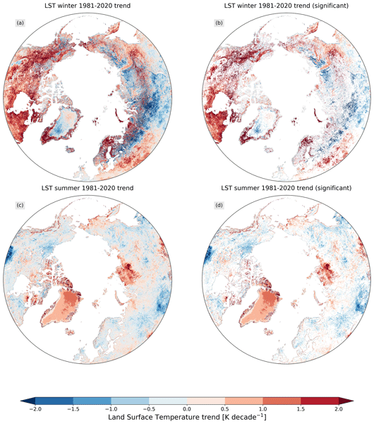
-
Permafrost active layer thickness for the Northern Hemisphere, v4.0 from MODIS LST, ERA5, 1997-2021
This dataset contains v4.0 permafrost active layer thickness data produced as part of the European Space Agency's (ESA) Climate Change Initiative (CCI) Permafrost project. It...
-
Permafrost ground temperature for the Northern Hemisphere, v4.0 from MODIS LST, ERA5, 1997-2021
This dataset contains v4.0 permafrost ground temperature data produced as part of the European Space Agency's (ESA) Climate Change Initiative (CCI) Permafrost project. It forms...
-
Permafrost extent for the Northern Hemisphere, v4.0 from MODIS LST, ERA5, 1997-2021
This dataset contains v4.0 permafrost extent data produced as part of the European Space Agency's (ESA) Climate Change Initiative (CCI) Permafrost project. It forms part of the...
-
Quaternary deposits map of Yana-Indigirka and Kolyma lowlands tundra zone, R-55-57, based on Landsat imagery
The Quaternary geology map was created for the Yana-Indigirka (eastern part) and Kolyma lowlands, tundra and partly forest-tundra zones. The map corresponds to the nomenclature...
-
Ground Temperature Map, 2000-2016, New Zealand
The product provides modeled mean annual ground temperatures (MAGT) at the top of the permafrost for New Zealand at 1 km spatial resolution. Permafrost probability (fraction...
-
T-MOSAiC 2021 myThaw data set, Circum-Arctic
The Terrestrial Multidisciplinary distributed Observatories for the Study of the Arctic Connections (T-MOSAiC) 2021 permafrost thaw data set provides standardized measurements...