Überspringen zum Hauptinhalt
  • Einloggen
Arctic Permafrost Geospatial Centre
    • Datensätze
    • Kategorien
    • Projekte
    • Sammlungen
    • Über uns
    • Kartenanwendung
  1. Start
  2. Gruppen
  3. AMPAC-Net Airborne
ampac-airborne

AMPAC-Net Airborne

This dataset collection is a data type subset of the AMPAC-Net project and contains CH4 concentrations, vertical profiles, fluxes from airborne and UAV measurements. mehr erfahren

Datensätze
8

Regionen

  • Alaskan and Canadian Arctic (1)

Produkte

  • AVIRIS-NG Level 1... (1)

Sensoren

  • Airborne... (1)

Räumliche Auflösung

  • 5 m (1)

Zeitliche Auflösung

  • Areas were surveyed once (1)

Stichworte

  • Infrared imagery (1)
  • Infrared radiance (1)
  • Land Surface (1)
  • Reflectance (1)
  • Visible imagery (1)

Mehr Stichworte anzeigen

Datenformate

  • ENVI binary (1)
  • ENVI binary image (1)
  • HTML (1)
  • JPEG (1)
  • PDF (1)

Mehr Datenformate anzeigen

Erstautoren

  • Miller, Charles E. (1)

Projekte

  • ABoVE (1)
  • AMPAC-Net Airborne (1)
  • Arctic Methane and... (1)
  • Land Cover (1)

Institute

  • Jet Propulsion... (1)

Herausgeber

  • ORNL DAAC (1)

close
  • Datensätze
  • Mitglieder
  • Über uns
  • Aktivitätsanzeige

1 Datensatz gefunden

Datenformate: PDF

Ergebnisse filtern
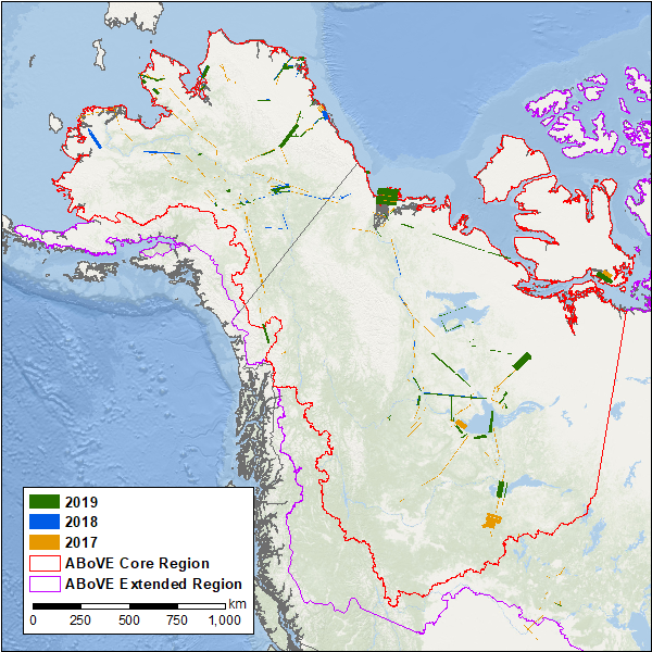
  • Hyperspectral Imagery AVIRIS-NG V2, 2017-2019, Alaskan and Canadian Arctic

    This dataset provides Level 1 radiance and Level 2 surface reflectance measured by the Airborne Visible/Infrared Imaging Spectrometer-Next Generation (AVIRIS-NG) instrument...
    • HTML
    • ENVI binary image
    • ENVI binary
    • JPEG
    • SHP
    • PDF
  • Über Arctic Permafrost Geospatial Centre
  • CKAN API
  • Open Knowledge Foundation

  • Unterstützt durch CKAN

Initiiert von

Bereitgestellt durch

Impressum | Datenschutzhinweis