Überspringen zum Hauptinhalt
  • Einloggen
Arctic Permafrost Geospatial Centre
    • Datensätze
    • Kategorien
    • Projekte
    • Sammlungen
    • Über uns
    • Kartenanwendung
  1. Start
  2. Gruppen
  3. ABoVE
above

ABoVE

The Arctic-Boreal Vulnerability Experiment (ABoVE) is a NASA Terrestrial Ecology Program field campaign that will be conducted in Alaska and Western Canada. ABoVE is a large-... mehr erfahren

Datensätze
10

Regionen

  • Alaska, USA (1)

Produkte

  • SAR estimates of... (1)

Sensoren

  • Phased Array type... (1)

Räumliche Auflösung

  • 12.5 m (1)

Zeitliche Auflösung

  • Varied (1)

Stichworte

  • Ebullition (1)
  • Lakes (1)
  • Methane (1)
  • Synthetic Aperture Radar (1)

Datenformate

  • HTML (1)
  • KML (1)
  • SHP (1)

Erstautoren

  • Melanie J. Engram (1)

Projekte

  • ABoVE (1)
  • AMPAC-Net Spatial Models (1)
  • Arctic Methane and... (1)
  • Biogeochemistry (1)

Institute

  • University of... (1)

Herausgeber

  • ORNL DAAC (1)

close
  • Datensätze
  • Mitglieder
  • Über uns
  • Aktivitätsanzeige

1 Datensatz gefunden

Projekte: ABoVE Räumliche Auflösung: 12.5 m

Ergebnisse filtern
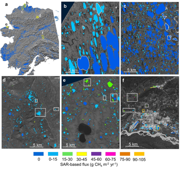
  • SAR-based Methane Ebullition Flux from Lakes, Five Regions, Alaska, 2007-2010

    This dataset provides Synthetic Aperture Radar (SAR) estimates of lake-source methane ebullition flux in mg CH4/m2/d for thousands of lakes in five regions across Alaska. The...
    • HTML
    • SHP
    • KML
  • Über Arctic Permafrost Geospatial Centre
  • CKAN API
  • Open Knowledge Foundation

  • Unterstützt durch CKAN

Initiiert von

Bereitgestellt durch

Impressum | Datenschutzhinweis