Überspringen zum Hauptinhalt
  • Einloggen
Arctic Permafrost Geospatial Centre
    • Datensätze
    • Kategorien
    • Projekte
    • Sammlungen
    • Über uns
    • Kartenanwendung
  1. Start
  2. Gruppen
  3. PerSys - ColdSpot CSP
persys-csp

PerSys - ColdSpot CSP

“ColdSpots” (CSP) are regions with good in-situ observation infrastructure. In these regions, permafrost monitoring on the ground has been taking place for many years or field... mehr erfahren

Datensätze
29

Regionen

  • Antarctica (1)

Produkte

  • Geomorphology (1)

Sensoren

  • Site names (STN) (1)

Räumliche Auflösung

Für diese Suche wurden keine Räumliche Auflösung gefunden.

Zeitliche Auflösung

Für diese Suche wurden keine Zeitliche Auflösung gefunden.

Stichworte

  • Geomorphology (1)
  • Permafrost (1)

Datenformate

  • PDF (1)
  • PNG (1)
  • SHP (1)

Erstautoren

  • Goyanes, Gabriel (1)

Projekte

  • ESA GlobPermafrost (1)
  • Land Cover (1)
  • Periglacial Inventories (1)
  • PerSys (1)
  • PerSys - ColdSpot CSP (1)

Institute

  • ZAMG... (1)

Herausgeber

  • PANGAEA (1)

close
  • Datensätze
  • Mitglieder
  • Über uns
  • Aktivitätsanzeige

1 Datensatz gefunden

Sensoren: Site names (STN)

Ergebnisse filtern
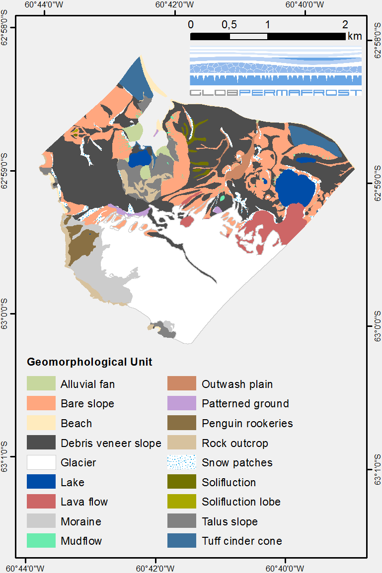
  • Geomorphological units from field mapping, Irizar - Crater Lake Area, Deception Island, Antarctica

    The map describes the main geomorphological features according to surface cover type on Irizar - Crater Lake Area, Deception Island, Antarctica. The map was developed to support...
    • PDF
    • SHP
    • PNG
  • Über Arctic Permafrost Geospatial Centre
  • CKAN API
  • Open Knowledge Foundation

  • Unterstützt durch CKAN

Initiiert von

Bereitgestellt durch

Impressum | Datenschutzhinweis