Preview
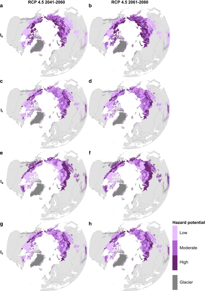
Displayed here, in a moderate Representative Concentration Pathway (RCP) 4.5 scenario for 2041-2060 and 2061–2080, are settlement index Is (a,b, refs71,72), risk zonation index Ir (c,d, ref.75), AHP (analytic hierarchy process based index) Ia (e,f) and consensus of the three Ic (g,h). Each index consists of three mutually exclusive classes delimiting areas of low, moderate and high hazard potential. World Borders dataset is distributed under CC BY-SA 3.0 license (https://creativecommons.org/licenses/by-sa/3.0/) on http://thematicmapping.org/downloads/world_borders.php.
Figure 3 from: Karjalainen, O., Aalto, J., Luoto, M. et al. Circumpolar permafrost maps and geohazard indices for near-future infrastructure risk assessments. Sci Data 6, 190037 (2019). https://doi.org/10.1038/sdata.2019.37 (This article is licensed under a Creative Commons Attribution 4.0 International License)
其他資訊
| 欄位 | 值 |
|---|---|
| 資料最後更新時間 | 2021年4月23日 |
| 後設資料最後更新時間 | 2021年11月1日 |
| 建立時間 | 2021年4月23日 |
| 格式 | JPEG |
| 授權條款 | Creative Commons Attribution 3.0 Unported |
| Datastore active | False |
| Datastore contains all records of source file | False |
| Has views | True |
| Id | 1c78bf30-d98c-4182-a166-e1620d639adf |
| Mimetype | image/jpeg |
| Package id | de5f004f-b7c3-48da-acc2-c081b9fc3e70 |
| Position | 0 |
| State | active |
Attention! The specified license is that of the dataset. Licenses from other sources, e.g. publications or figures related to the dataset, may be subject to other licenses.