-
Land cover classification of tundra environments from Landsat, 2000-2001, Lena Delta, Laptev Sea Region (RU)
The study was based on land cover classification of three almost cloud free Landsat-7 ETM+ satellite images. The acquisition dates are 27 July 2000 (path 131, rows 8 and 9) and...
-
Raster Circumpolar Arctic Vegetation Map (CAVM) from AVHRR, MODIS and elevation data
Land cover maps are the basic data layer required for understanding and modeling ecological patterns and processes. The Circumpolar Arctic Vegetation Map (CAVM), produced in...
-
Database of Quaternary Deposits from Maps, East and Central Siberia (RU)
This digital database is the product of collaboration between the U.S. Geological Survey, the Alfred Wegener Institute for Polar and Marine Research Potsdam, Foothill College...
-
Ground ice maps from paleogeographic modelling approach, Canada (CA)
Ground ice melt caused by climate-induced permafrost degradation may trigger significant ecological change, damage infrastructure, and alter biogeochemical cycles. The...
-
Circumpolar raster grids of permafrost extent and geohazard potential for near-future climate scenarios
One of the consequences of warming climate is rising ground temperatures and degradation of perennially frozen ground, permafrost. Thawing of near-surface permafrost can cause...
-
Satellite Photo Mosaic from Corona-KH4, 1962-06-28, Northern Seward Peninsula, Alaska (US)
This raster dataset is a high-resolution mosaic of 4 Corona-KH4 satellite photos over the northern Seward Peninsula in Northwest Alaska dated to 28 July 1962. The mosaic covers...
-
Robust trends of landscape dynamics in the Arctic Lena Delta with temporally dense Landsat time-series stacks
The robust Theil-Sen regression algorithm was used to calculate trend parameters (slope, intercept, confidence intervals) on Landsat time-series stack in the north-east Siberian...
-
Permafrost Extent and Ground Temperature Map, 2000-2016, Northern Hemisphere Permafrost
The product provides modeled mean annual ground temperatures (MAGT) at the top of the permafrost for the Northern Hemisphere at 1 km spatial resolution. Permafrost probability...
-
Lake Ice Classification from Sentinel-1, 2015-2016, Teshekpuk, Alaska (US)
Weekly lake ice classifications distinguish grounded ice and floating ice in lakes based on Sentinel-1A and Sentinel-1B synthetic aperture radar time-series with a resolution of...
-
Vegetation Height from Sentinel-1 and Sentinel-2, Kytalyk, 2016-2018, Central Yakutia (RU)
Vegetation height has been derived from Sentinel-1 satellite data acquired in VV mode with a resolution of 20 m. Vegetation height was estimated using an empirical model on...
-
Lake Ice Classification from Sentinel-1, 2016-2017, Cape Espenberg Lowland, Alaska (US)
Lake ice classifications distinguish grounded ice and floating ice in lakes based on Sentinel-1A and Sentinel-1B synthetic aperture radar time-series with a resolution between...
-
Vegetation Height from Sentinel-1 and Sentinel-2, 2016-2018, Teshekpuk, Arctic Alaska (US)
Vegetation height has been derived from Sentinel-1 satellite data acquired in VV mode with a resolution of 20 m. Vegetation height was estimated using an empirical model on...
-
Northern Circumpolar Soil Carbon Database, Russia, geotiff- and netCDF-files
The Northern Circumpolar Soil Carbon Database version 2 (NCSCDv2) is a geospatial database created for the purpose of quantifying storage of organic carbon in soils of the...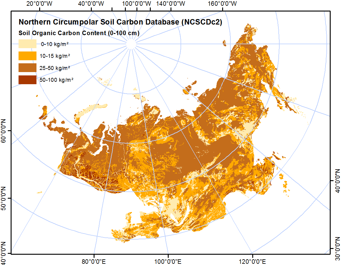
-
Trends of Land Surface Change from Landsat time-series 1999-2014, Eastern Canada, UTM Zone 18N, 62°N - 64°N (CA)
The Hot Spot Regions of Permafrost Change (HRPC) product maps changes in surface characteristics using the full Landsat archive (TM, ETM+, OLI) for the peak summer season (July,...
-
Trends of Land Surface Change from Landsat time-series 1999-2014, Eastern Canada, UTM Zone 18N, 60°N - 62°N (CA)
The Hot Spot Regions of Permafrost Change (HRPC) product maps changes in surface characteristics using the full Landsat archive (TM, ETM+, OLI) for the peak summer season (July,...
-
Trends of Land Surface Change from Landsat time-series 1999-2014, Eastern Canada, UTM Zone 18N, 58°N - 60°N (CA)
The Hot Spot Regions of Permafrost Change (HRPC) product maps changes in surface characteristics using the full Landsat archive (TM, ETM+, OLI) for the peak summer season (July,...
-
Trends of Land Surface Change from Landsat time-series 1999-2014, Eastern Canada, UTM Zone 18N, 56°N - 58°N (CA)
The Hot Spot Regions of Permafrost Change (HRPC) product maps changes in surface characteristics using the full Landsat archive (TM, ETM+, OLI) for the peak summer season (July,...
-
Trends of Land Surface Change from Landsat time-series 1999-2014, Eastern Canada, UTM Zone 18N, 54°N - 56°N (CA)
The Hot Spot Regions of Permafrost Change (HRPC) product maps changes in surface characteristics using the full Landsat archive (TM, ETM+, OLI) for the peak summer season (July,...
-
Trends of Land Surface Change from Landsat time-series 1999-2014, Eastern Canada, UTM Zone 18N, 52°N - 54°N (CA)
The Hot Spot Regions of Permafrost Change (HRPC) product maps changes in surface characteristics using the full Landsat archive (TM, ETM+, OLI) for the peak summer season (July,...
-
Trends of Land Surface Change from Landsat time-series 1999-2014, Eastern Canada, UTM Zone 18N, 50°N - 52°N (CA)
The Hot Spot Regions of Permafrost Change (HRPC) product maps changes in surface characteristics using the full Landsat archive (TM, ETM+, OLI) for the peak summer season (July,...


您也可以使用API (應用程式介面) (see API 文件)註冊。