-
The fractional land cover estimates from the Boreal–Arctic Wetland and Lake Dataset (BAWLD), 2021, Circum-Arctic
The Boreal and Arctic Wetland and Lake Dataset (BAWLD) provides estimates of fractional land cover of 19 land cover classes within 0.5° ×0.5° grid cells. The total area of the...
-
Circumpolar Thermokarst Landscapes, 2015, Circum-Arctic
This data set provides the distribution of thermokarst landscapes in the boreal and tundra ecoregions within the northern circumpolar permafrost zones. This dataset provides an...
-
Monthly global dataset of Wetland Area and Dynamics for Methane Modeling (WAD2M) from Remote Sensing, 2000-2020
Seasonal and interannual variations in global wetland area is a strong driver of fluctuations in global methane (CH4) emissions. Current maps of global wetland extent vary with...
-
Aufeis (naleds) from 1958 historical maps and 2013-2017 Landsat-8 OLI images, Indigirka River basin, Siberia (RU)
The GIS database contains the data of aufeis (naleds) in the Indigirka River basin (Russia) from historical and nowadays sources, and complete ArcGIS 10.1/10.2 and Qgis 3*...
-
Aufeis (naleds) from 1958 historical maps and 2013-2019 Landsat-8 OLI images, Chukotka region, Siberia (RU)
The GIS database contains the data of aufeis (naled) in the Chukotka region from historical and nowadays sources, and complete ArcGIS 10.1/10.2 and Qgis 3* projects to view and...
-
Aufeis (naleds) from 1958 historical maps and 2013-2017 Landsat-8 OLI images, Kolyma River basin, Siberia (RU)
The GIS database contains the data of aufeis (naleds) in the Kolyma River basin (Russia) from historical and nowadays sources, and complete ArcGIS 10.1/10.2 and Qgis 3* projects...
-
Lake-DOC Database (PeRL-DOCv1), 1979-2017, Permafrost-Region
The pan-Arctic Permafrost-Region Lake-DOC version1 database contains surface water samples of lakes in the permafrost regions of Alaska (49.3 %), Canada (24.2 %), Greenland (3.2...
-
Historic Lake Drainage from Remote Sensing Datasets, 1955-2017, Western Arctic Coastal Plain, Northern Alaska (US)
We identified all lakes larger than 10 hectares (ha) that drained completely or partially (greater than 25 %) between 1955 and 2017 using historical (original) USGS topographic...
-
Permafrost Region Pond and Lake Database (PeRL)
The Permafrost Region Pond and Lake Database (PeRL) presents the results of a circum-arctic effort to map ponds and lakes from modern (2002-2013) high-resolution aerial and...
-
Lake Database from Landsat TM and ETM+,1970s, 2000s, 2013-2014, Western Alaska (US)
This vector data layer covers 6 major lake districts (Baldwin Peninsula, Kobuk Delta, Selawik Lowland, Northern Seward Peninsula, Central Seward Peninsula, and Yukon-Kuskokwim...
-
Thermo-erosional valleys and streams in ice-rich permafrost lowlands from RapidEye, 2010, Buor Khaya Peninsula,...
The published data set provides an inventory of thermo-erosional landforms and streams in three lowland areas underlain by ice-rich permafrost of the Yedoma-type Ice Complex at...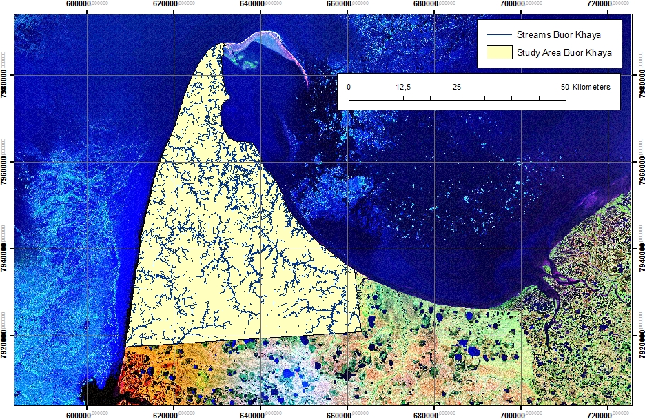
-
Thermo-erosional valleys and streams in ice-rich permafrost lowlands from Landsat, 2000, Hexagon, 1975, Lena Delta,...
The published dataset provides an inventory of thermo-erosional landforms and streams in three lowland areas underlain by ice-rich permafrost of the Yedoma-type Ice Complex at...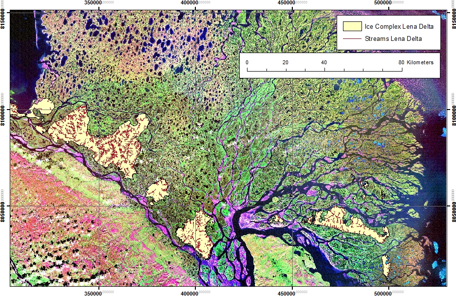
-
Thermo-erosional valleys and streams in ice-rich permafrost lowlands from Landsat, 2000, Hexagon, 1975, Cape...
The published dataset provides an inventory of thermo-erosional landforms and streams in three lowland areas underlain by ice-rich permafrost of the Yedoma-type Ice Complex at...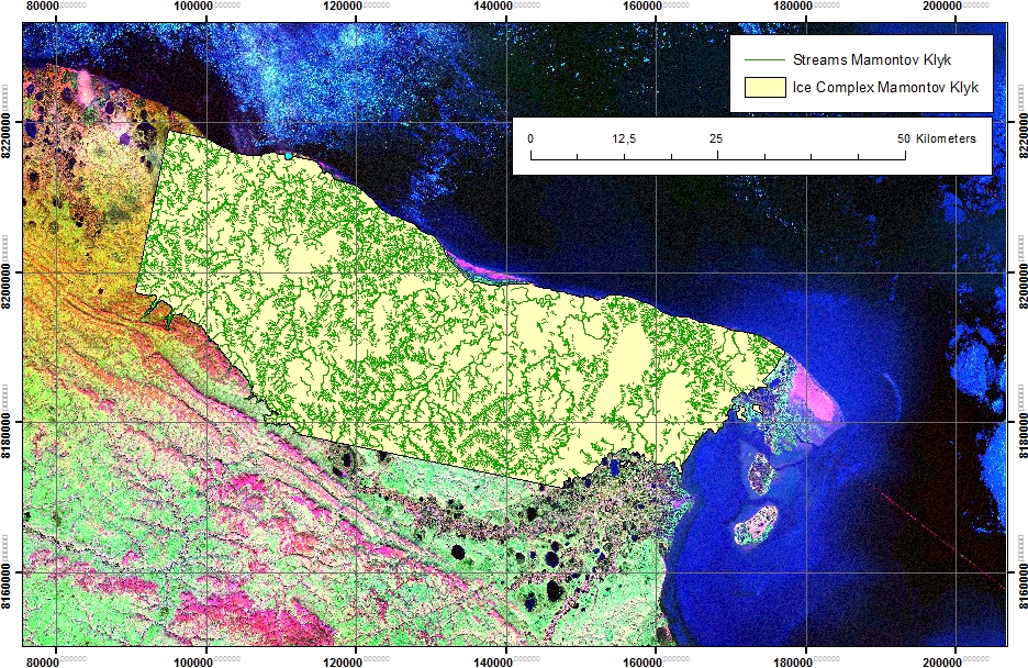
-
Potential Future Lake Drainage from an IfSAR-Derived Digital Surface Model, 2002-2003, Western Arctic Coastal Plain,...
Assessment of lakes for their future potential to drain relied on the 2002/03 airborne Interferometric Synthetic Aperture Radar (IFSAR) Digital Surface Model (DSM) data for the...
-
Lakes from Landsat 2000-2001, Lena Delta, Laptev and East Siberian Sea Region (RU)
This data set provides a detailed inventory of lakes in the Lena Delta, northern Siberia, with respect to the lakes' association with one of the three geomorphological main...
-
Trend analysis of lake dynamics from Landsat time-series 1999-2014, Alaska North Slope, Alaska (US)
The dataset was created with a methodology based on machine-learning based classification of robust trends of multi-spectral indices of Landsat data (TM,ETM+, OLI) and object-...
-
Trend analysis of lake dynamics from Landsat time-series 1999-2014, Kolyma Lowland, Siberia (RU)
The dataset was created with a methodology based on machine-learning based classification of robust trends of multi-spectral indices of Landsat data (TM,ETM+, OLI) and object-...
-
Trend analysis of lake dynamics from Landsat time-series 1999-2014, Central Yakutia, Siberia (RU)
The dataset was created with a methodology based on machine-learning based classification of robust trends of multi-spectral indices of Landsat data (TM,ETM+, OLI) and object-...
-
Trend analysis of lake dynamics from Landsat time-series 1999-2014, Kobuk-Selawik-Lowlands, Alaska (US)
The dataset was created with a methodology based on machine-learning based classification of robust trends of multi-spectral indices of Landsat data (TM,ETM+, OLI) and object-...
-
Aufeis (naleds) from 1958 historical maps and 2013-2017 Landsat-8 OLI images, Yana River basin, Siberia (RU)
The GIS database contains the data of aufeis (naled) in the Yana River basin (Russia) from historical and nowadays sources, and complete ArcGIS 10.1/10.2 and Qgis 3* projects to...