-
Global SCIAMACHY and GOSAT Level 3 gridded atmospheric column-average methane (XCH4) product in Obs4MIPs format, 2003-2014
This dataset contains satellite-derived atmospheric column-average dry-air mole fractions of methane (XCH4), and is a Level 3 gridded product in Obs4MIPs format. It has been...
-
PEATMAP - peatland distribution maps based on meta-analysis, 1999-2010, Global
PEATMAP is a GIS shapefile dataset that shows a distribution of peatlands that covers the entire world. It was produced by combining the most high quality available peatland map...
-
Global 0.5-deg Wetland Methane Emissions and Uncertainty (WetCHARTs v1.0), 2009-2010
This data set provides global monthly wetland methane (CH4) emissions and uncertainty data products derived from an ensemble of multiple terrestrial biosphere models, wetland...
-
Global-Gridded Daily Methane Emissions from Inland Dam-Reservoir Systems, 2002-2015
This dataset includes global maps of methane (CH4) emissions from inland dam-reservoir systems at 0.25-degree spatial resolution. Daily emission rates (as grams of CH4 per day...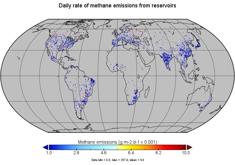
-
Global methane data from 2002 to present derived from satellite observations
This dataset provides observations of atmospheric methane (CH4) amounts obtained from observations collected by several current and historical satellite instruments. Methane is... -
Monthly global dataset of Wetland Area and Dynamics for Methane Modeling (WAD2M) from Remote Sensing, 2000-2020
Seasonal and interannual variations in global wetland area is a strong driver of fluctuations in global methane (CH4) emissions. Current maps of global wetland extent vary with...
-
The Wetland and Wetland CH4 Inter-comparison of Models Project (WETCHIMP) data archive
This archive contains the raw and post-processed model output used in the The Wetland and Wetland CH4 Inter-comparison of Models Project (WETCHIMP). There are top-level...