-
Surface Soil Moisture from ENVISAT ASAR GM, 2005-2011, Yakutsk, Central Yakutia (RU)
The SAR Surface Soil Moisture (SSM) product is derived from the ENVISAT ASAR sensor operating in Global Monitoring (GM) mode. The SAR SSM product is a weekly mean composite at 1...
-
Water Body Classification from ENVISAT ASAR Wide Swath, 2007-2008, Yakutsk, Central Yakutia (RU)
The regional waterbody classification is derived from ENVISAT ASAR Wide Swath data with 150 m resolution. Maps represent the extent of water bodies for the summer months July...
-
Water Body Classification from ENVISAT ASAR Wide Swath, 2007-2011, Mackenzie River Valley and Delta, Beaufort Sea Region (CA)
The regional waterbody classification is derived from ENVISAT ASAR Wide Swath data with 150 m resolution. Maps represent the extent of water bodies for the summer months July...
-
Rockglacier and Slope Instability Inventory from differential SAR interferograms and optical imagery, 1998-2016,...
Rockglaciers and other periglacial processes were mapped using visual analysis of differential SAR interferograms and satellite optical images (Google Satellite, Bing Aerial)...
-
T-MOSAiC 2021 myThaw data set, Circum-Arctic
The Terrestrial Multidisciplinary distributed Observatories for the Study of the Arctic Connections (T-MOSAiC) 2021 permafrost thaw data set provides standardized measurements...
-
Pingo Database, 2022, Svalbard (NO)
The data contains the list of pingo and pingo-like forms over Svalbard archipelago. Each pingo is assigned with following data: coordinates, absolute height of pingo baseline,...
-
Distribution and morphometry of pingos, western Canadian Arctic, Northwest Territories, (CA)
GIS shape files including spatial and morphometric data of pingos in the western Canadian Arctic and accompanying Excel spreadsheet summarizing metrics for pingos of differing...
-
Inorganic and organic hydrochemistry of lakes and ponds in continuous permafrost landscapes in the western Canadian...
Between 2006 and 2015 inorganic and organic hydrochemical parameters and stable water isotope characteristics were measured in lakes and ponds in continuous permafrost...
-
Ground layer above-ground biomass of 39 sites from 2018 central Chukotka (RU) - Raw data of dry weight for each...
Field investigations were performed in four areas: a treeless mountainous tundra (16-KP-04; Lake Rauchuagytgyn area), tundra-taiga transition zone (16-KP-01, Lake Ilirney area)...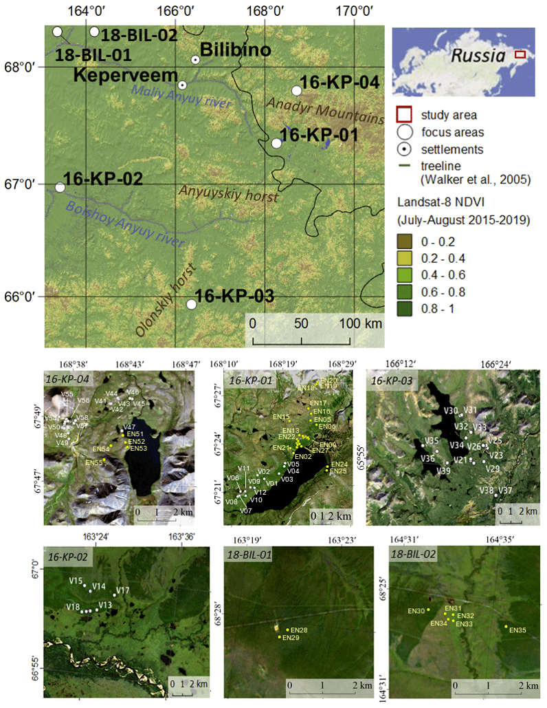
-
Ground layer above-ground biomass of 25 sites from 2018 central Lena Delta (RU) - Raw data of dry weight for each...
Field investigations were performed in the central Lena Delta. In total, 25 sites were investigated. The sites were chosen to represent a variety of vegetation communities of...
-
Remote sensing reflectance (Rrs) of the surface water during 4 expeditions from spring to fall in 2019, Mackenzie...
Vertical profiles of downwelling irradiance (Ed) and upwelling radiance (Lu) were measured during legs 2, 3, and 4 using a Compact-Optical Profiling System (C-OPS) in an ICE-Pro...
-
Particle absorption (aP) in the surface water during 4 expeditions from spring to fall in 2019, Mackenzie Delta Region (CA)
Absorbance of particles retained on GF/F (0.7 µm) filters was measured using a Varian Cary 100 spectrophotometer equipped with an integrated sphere. Absorbance and reflectance...
-
Phytoplankton pigment concentrations measured by HPLC in the surface water during 4 expeditions from spring to fall...
The determination of phytoplankton using high performance liquid chromatography (HPLC) is detailed in Hooker et al. (2005; doi:10.1364/AO.44.000553) and Ras et al. (2008;...
-
Stable water isotopes (δ18O, δD, d-excess) in the surface water during 4 expeditions from spring to fall in 2019,...
Water samples for stable isotopes were collected untreated in 10 mL HDPE vials, sealed tightly, stored in the dark at 4°C. Measurements were conducted at the laboratory facility...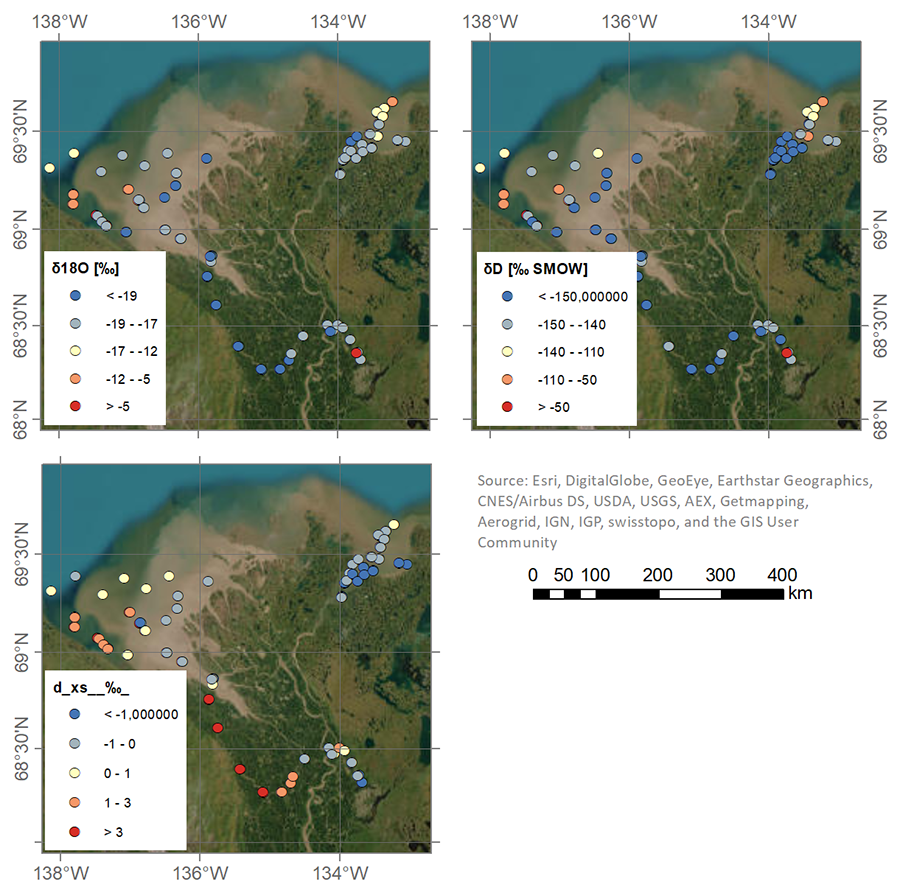
-
Land Cover Classification from Sentinel-1 and Sentinel-2, 2015-2018, Mackenzie Delta, Beaufort Sea Region (CA)
Land cover classes have been derived from bands of Sentinel-2 (bands 3 (green, 10m), 4 (red, 10m), 8 (near infrared, 10m), 11 (SWIR, 20m) and 12 (SWIR, 20m)) as well as...
-
Frozen State Backscatter Intensity from Sentinel-1, 2016-2017, Mackenzie Delta, Beaufort Sea Region (CA)
Frozen state backscatter intensity was derived from Sentinel-1 acquisitions from December 2015 and 2016. By excluding the effects of liquid water content (acquisitions under...
-
Dissolved organic carbon (DOC) concentration in the surface water during 4 expeditions from spring to fall in 2019,...
Water samples were filtered through 0.7 µm GF/F filter, and acidified with 25 µL Suprapur HCl (10 M) on the same day of sampling. DOC samples were stored and kept at 4°C in the...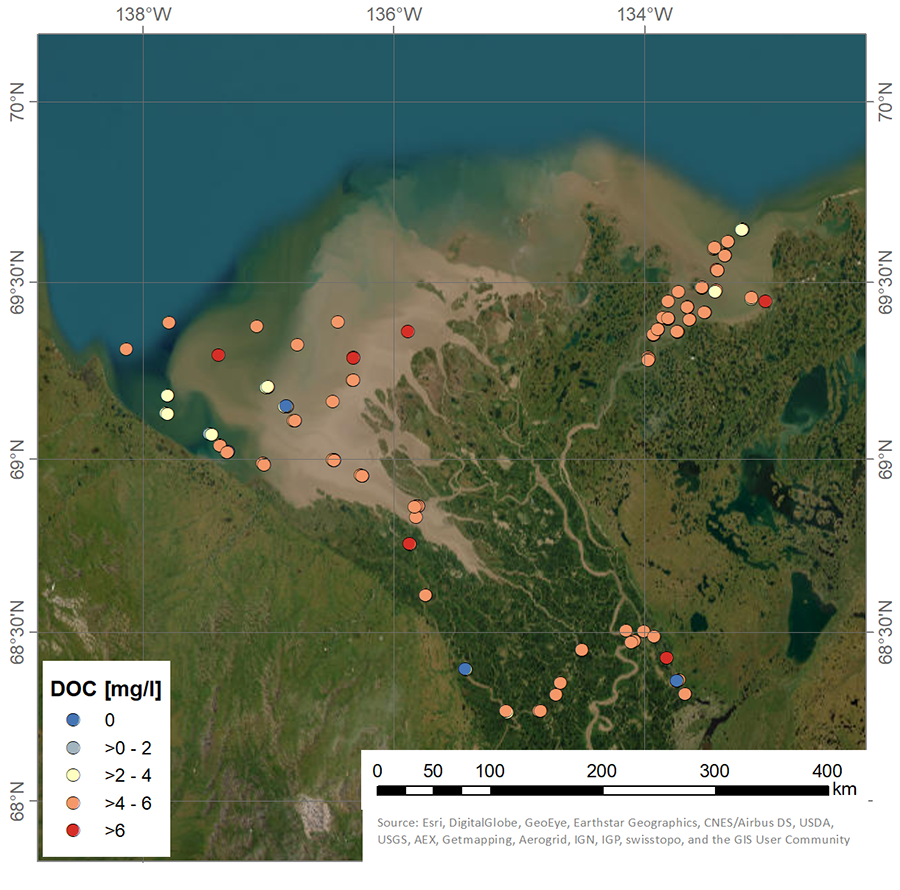
-
Bacteria cells in the surface water during 4 expeditions from spring to fall in 2019, Mackenzie Delta Region (CA)
Samples for bacterial abundance (1.5 mL) were preserved with glutaraldehyde (1% final concentration) and stored at -80°C. Samples were stained with SYBRTM Green I (Thermofisher...
-
Particulate organic carbon (POC) and particulate organic nitrogen (PON) concentrations in the surface water during 4...
Particulate organic carbon (POC) and particulate organic nitrogen (PON) concentrations were obtained from water samples filtered on precombusted (450°C for >5 hours) 47mm...
-
Suspended particulate matter (SPM), Total particulate carbon (TPC) and Total particulate nitrogen (TPN)...
Material for the determination of suspended particulate matter (SPM), total particulate carbon (TPC) and total particulate nitrogen (TPN) was obtained by filtering 300-700 mL...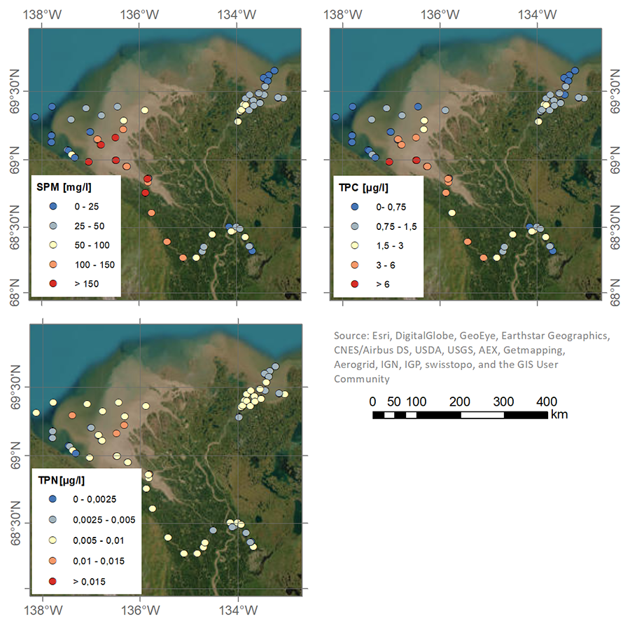
Također možete pristupiti registru koristeći API (vidi Dokumentacija API-ja).