-
Submarine Permafrost Map (SuPerMAP), modeled with CryoGrid 2, Circum-Arctic
This data set contains a first‐order estimate of distribution, thickness and ice-content of submarine permafrost on the Arctic shelf based on a numerical heat transfer model....
-
Ground Temperature Map, 2000-2017, Antarctic
The product provides modeled mean annual ground temperatures (MAGT) at the top of the permafrost for Antarctica and Subantarctic islands at 1 km spatial resolution. Permafrost...
-
Ground Temperature Map, 2000-2016, Andes
The product provides modeled mean annual ground temperatures (MAGT) at the top of the permafrost for Andes at 1 km spatial resolution. Permafrost probability (fraction values...
-
Ground Temperature Map, 2000-2016, East African Plateau
The product provides modeled mean annual ground temperatures (MAGT) at the top of the permafrost for the East African Plateau at 1 km spatial resolution. Permafrost probability...
-
Northern Circumpolar Soil Carbon Database, Kazaksthan, geotiff- and netCDF-files
The Northern Circumpolar Soil Carbon Database version 2 (NCSCDv2) is a geospatial database created for the purpose of quantifying storage of organic carbon in soils of the...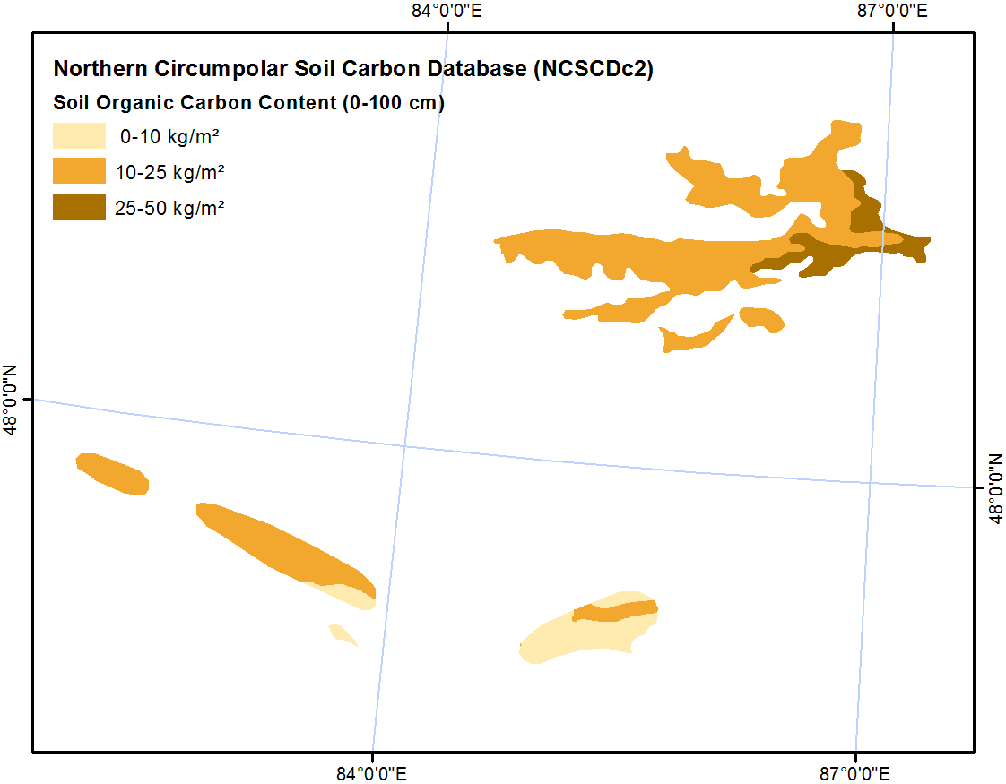
-
Rockglacier and Slope Instability Inventory from differential SAR interferograms and optical imagery, 1998-2016,...
Rockglaciers and other periglacial processes were mapped using visual analysis of differential SAR interferograms and satellite optical images (Google Satellite, Bing Aerial)...
-
Rockglacier and Slope Instability Inventory from differential SAR interferograms and optical imagery, 1998-2016,...
Rockglaciers and other periglacial processes were mapped using visual analysis of differential SAR interferograms and satellite optical images (Google Satellite, Bing Aerial)...
-
Land Cover Classification from Sentinel-1 and Sentinel-2, 2015-2018, Western Siberia (RU)
Land cover classes have been derived from bands of Sentinel-2 (bands 3 (green, 10m), 4 (red, 10m), 8 (near infrared, 10m), 11 (SWIR, 20m) and 12 (SWIR, 20m)) as well as...
-
Land Cover Classification from Sentinel-1 and Sentinel-2, 2015-2018, Yukon Delta, Alaska (US)
Land cover classes have been derived from bands of Sentinel-2 (bands 3 (green, 10m), 4 (red, 10m), 8 (near infrared, 10m), 11 (SWIR, 20m) and 12 (SWIR, 20m)) as well as...
-
Land Cover Classification from Sentinel-1 and Sentinel-2, 2015-2018, Seward Peninsula, Alaska (US)
Land cover classes have been derived from bands of Sentinel-2 (bands 3 (green, 10m), 4 (red, 10m), 8 (near infrared, 10m), 11 (SWIR, 20m) and 12 (SWIR, 20m)) as well as...
-
Land Cover Classification from Sentinel-1 and Sentinel-2, 2015-2018, Lena Delta, Laptev and East Siberian Sea Region (RU)
Land cover classes have been derived from bands of Sentinel-2 (bands 3 (green, 10m), 4 (red, 10m), 8 (near infrared, 10m), 11 (SWIR, 20m) and 12 (SWIR, 20m)) as well as...
-
Land Cover Classification from Sentinel-1 and Sentinel-2, 2015-2018, Kytalyk, Central Yakutia (RU)
Land cover classes have been derived from bands of Sentinel-2 (bands 3 (green, 10m), 4 (red, 10m), 8 (near infrared, 10m), 11 (SWIR, 20m) and 12 (SWIR, 20m)) as well as...
-
Land Cover Classification from Sentinel-1 and Sentinel-2, 2015-2018, Umiaq, Canadian (Arctic) Archipelago (CA)
Land cover classes have been derived from bands of Sentinel-2 (bands 3 (green, 10m), 4 (red, 10m), 8 (near infrared, 10m), 11 (SWIR, 20m) and 12 (SWIR, 20m)) as well as...
-
Land Cover Classification from Sentinel-1 and Sentinel-2, 2015-2018, Teshekpuk, Alaska (US)
Land cover classes have been derived from bands of Sentinel-2 (bands 3 (green, 10m), 4 (red, 10m), 8 (near infrared, 10m), 11 (SWIR, 20m) and 12 (SWIR, 20m)) as well as...
-
Land Cover Classification from Sentinel-1 and Sentinel-2, 2015-2018, Barrow, Alaska (US)
Land cover classes have been derived from bands of Sentinel-2 (bands 3 (green, 10m), 4 (red, 10m), 8 (near infrared, 10m), 11 (SWIR, 20m) and 12 (SWIR, 20m)) as well as...
-
Frozen State Backscatter Intensity from Sentinel-1, 2015-2016, West Siberia (RU)
Frozen state backscatter intensity was derived from Sentinel-1 acquisitions from December 2015 and 2016. By excluding the effects of liquid water content (acquisitions under...
-
Frozen State Backscatter Intensity from Sentinel-1, 2015-2016, Usa Basin, European Russia (RU)
Frozen state backscatter intensity was derived from Sentinel-1 acquisitions from December 2015 and 2016. By excluding the effects of liquid water content (acquisitions under...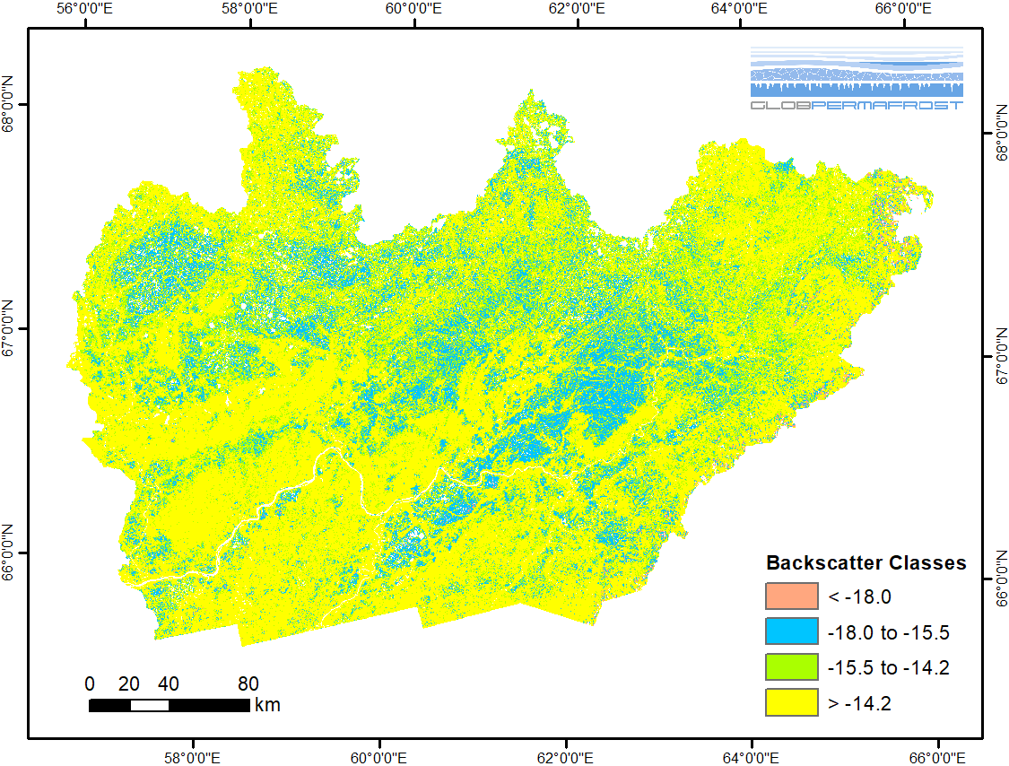
-
Frozen State Backscatter Intensity from Sentinel-1, 2015-2016, Teshekpuk, Alaska (US)
Frozen state backscatter intensity was derived from Sentinel-1 acquisitions from December 2015 and 2016. By excluding the effects of liquid water content (acquisitions under...
-
Frozen State Backscatter Intensity from Sentinel-1, 2015-2016, Toolik, Alaska (US)
Frozen state backscatter intensity was derived from Sentinel-1 acquisitions from December 2015 and 2016. By excluding the effects of liquid water content (acquisitions under...
-
Frozen State Backscatter Intensity from Sentinel-1, 2015-2016, Barrow, Alaska (US)
Frozen state backscatter intensity was derived from Sentinel-1 acquisitions from December 2015 and 2016. By excluding the effects of liquid water content (acquisitions under...
Можете да получите също така достъп до този регистър, като използвате връзката API (see API документация).