-
Permafrost active layer thickness for the Northern Hemisphere, v4.0 from MODIS LST, ERA5, 1997-2021
This dataset contains v4.0 permafrost active layer thickness data produced as part of the European Space Agency's (ESA) Climate Change Initiative (CCI) Permafrost project. It...
-
Permafrost ground temperature for the Northern Hemisphere, v4.0 from MODIS LST, ERA5, 1997-2021
This dataset contains v4.0 permafrost ground temperature data produced as part of the European Space Agency's (ESA) Climate Change Initiative (CCI) Permafrost project. It forms...
-
Permafrost extent for the Northern Hemisphere, v4.0 from MODIS LST, ERA5, 1997-2021
This dataset contains v4.0 permafrost extent data produced as part of the European Space Agency's (ESA) Climate Change Initiative (CCI) Permafrost project. It forms part of the...
-
Ground Temperature Map, 2000-2016, New Zealand
The product provides modeled mean annual ground temperatures (MAGT) at the top of the permafrost for New Zealand at 1 km spatial resolution. Permafrost probability (fraction...
-
T-MOSAiC 2021 myThaw data set, Circum-Arctic
The Terrestrial Multidisciplinary distributed Observatories for the Study of the Arctic Connections (T-MOSAiC) 2021 permafrost thaw data set provides standardized measurements...
-
Frozen State Backscatter Intensity from Sentinel-1, 2016-2017, Mackenzie Delta, Beaufort Sea Region (CA)
Frozen state backscatter intensity was derived from Sentinel-1 acquisitions from December 2015 and 2016. By excluding the effects of liquid water content (acquisitions under...
-
Circumpolar raster grids of permafrost extent and geohazard potential for near-future climate scenarios
One of the consequences of warming climate is rising ground temperatures and degradation of perennially frozen ground, permafrost. Thawing of near-surface permafrost can cause...
-
Permafrost active layer thickness for the Northern Hemisphere, v3.0 from MODIS LST, ERA5, 1997-2019
This dataset contains permafrost active layer thickness data produced as part of the European Space Agency's (ESA) Climate Change Initiative (CCI) Permafrost project. It forms... -
Permafrost active layer thickness for the Northern Hemisphere, v2.0 from MODIS LST, ERA5, 1997-2018
This dataset contains permafrost active layer thickness data produced as part of the European Space Agency's (ESA) Climate Change Initiative (CCI) Permafrost project. It forms...
-
Permafrost extent for the Northern Hemisphere, v3.0 from MODIS LST, ERA5, 1997-2019
This dataset contains permafrost extent data produced as part of the European Space Agency's (ESA) Climate Change Initiative (CCI) Permafrost project. It forms part of the... -
Permafrost ground temperature for the Northern Hemisphere, v3.0 from MODIS LST, ERA5, 1997-2019
This dataset contains permafrost ground temperature data produced as part of the European Space Agency's (ESA) Climate Change Initiative (CCI) Permafrost project. It forms part... -
Permafrost ground temperature for the Northern Hemisphere, v2.0 from MODIS LST, ERA5, 1997-2018
This dataset contains permafrost ground temperature data produced as part of the European Space Agency's (ESA) Climate Change Initiative (CCI) Permafrost project. It forms part...
-
Permafrost extent for the Northern Hemisphere, v2.0 from MODIS LST, ERA5, 1997-2018
This dataset contains permafrost extent data produced as part of the European Space Agency's (ESA) Climate Change Initiative (CCI) Permafrost project. It forms part of the first...
-
Permafrost Extent and Ground Temperature Map, 2000-2016, Northern Hemisphere Permafrost
The product provides modeled mean annual ground temperatures (MAGT) at the top of the permafrost for the Northern Hemisphere at 1 km spatial resolution. Permafrost probability...
-
Ground Temperature Map, 2000-2017, Antarctic
The product provides modeled mean annual ground temperatures (MAGT) at the top of the permafrost for Antarctica and Subantarctic islands at 1 km spatial resolution. Permafrost...
-
Ground Temperature Map, 2000-2016, Andes
The product provides modeled mean annual ground temperatures (MAGT) at the top of the permafrost for Andes at 1 km spatial resolution. Permafrost probability (fraction values...
-
Ground Temperature Map, 2000-2016, East African Plateau
The product provides modeled mean annual ground temperatures (MAGT) at the top of the permafrost for the East African Plateau at 1 km spatial resolution. Permafrost probability...
-
Frozen State Backscatter Intensity from Sentinel-1, 2015-2016, West Siberia (RU)
Frozen state backscatter intensity was derived from Sentinel-1 acquisitions from December 2015 and 2016. By excluding the effects of liquid water content (acquisitions under...
-
Frozen State Backscatter Intensity from Sentinel-1, 2015-2016, Usa Basin, European Russia (RU)
Frozen state backscatter intensity was derived from Sentinel-1 acquisitions from December 2015 and 2016. By excluding the effects of liquid water content (acquisitions under...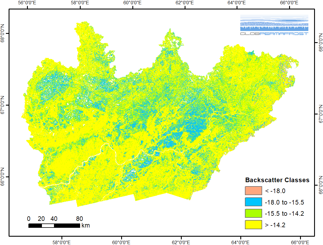
-
Frozen State Backscatter Intensity from Sentinel-1, 2015-2016, Teshekpuk, Alaska (US)
Frozen state backscatter intensity was derived from Sentinel-1 acquisitions from December 2015 and 2016. By excluding the effects of liquid water content (acquisitions under...
Можете да получите също така достъп до този регистър, като използвате връзката API (see API документация).