-
Dissolved methane and hydrochemical parameters in ice cores from 2017, Bykovsky Peninsula, Lena Delta
Data were analyzed to study the role of an winter ice cover for methane cycles of three different stages in the lake-lagoon-shelf transition in a region of rapidly thawing...
-
Database of Ice-Rich Yedoma Permafrost (IRYP)
We synthesized data on the circum-Arctic and sub-Arctic distribution and thickness of Yedoma for compiling a preliminary circum-polar Yedoma map. For compiling this map, we used...
-
Methane and nitrous oxide sea-air fluxes calculated from samples collected in the North American Arctic Ocean (2015–2...
This dataset contains methane and nitrous oxide dissolved gas concentration, dissolved methane carbon isotope, and ancillary hydrographic data from research cruises in the North...
-
Chamber measured methane transport through individual aerenchymous plants at a boreal fen and a bog
The presented dataset contains chamber measurements of methane transport (mg CH₄ g dry plant mass-1 day-1) through individual aerenchymous peatland plants and the ancillary data...
-
Eddy covariance carbon fluxes and ancillary data, Samoylov Island, Lena River Delta, 2014-2015
This dataset contains fluxes of carbon dioxide and methane on an active flood plain in the Siberian Lena River Delta during the growing seasons 2014 and 2015 by means of the...
-
Methane fluxes, soil gas profiles and microbial activities in ponds at Samoylov, 2002 & 2013
Methane (CH4) production, oxidation, and emission were studied in ponds of the permafrost-affected polygonal tundra in northeast Siberia. Summer CH4 fluxes were measured with...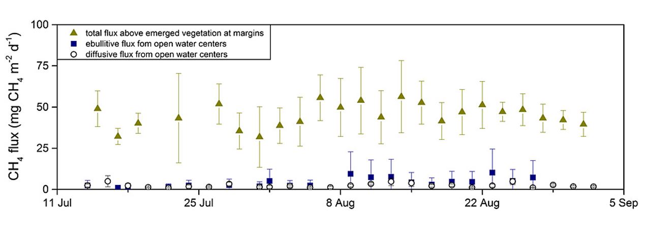
-
Soil incubation data from ice-rich permafrost deposits in Northeast Siberia, 2014
CO2 and CH4 production in aerobic and anaerobic incubation in sediments samples from Muostakh Island (sample code MUO12), the Buor Khaya Peninsula (BK8), and Bol'shoy Lyakhovsky...
-
Soil and incubation data of permafrost-affected soils in Samoylov, 2011 & 2013
The effects of oxygen availability, freezing and thawing, temperature, and labile organic matter (OM) additions on greenhouse gas production were studied in northeast Siberian...
-
Geochemistry of incubated permafrost and seawater from the western Canadian Arctic
We present geochemical and hydrochemical information on individual permafrost and seawater samples from the Yukon Coast in the western Canadian Arctic used for an incubation...
-
Anaerobic incubation measurements (CH4+CO2) and microbe quantification, Lena Delta, 2018
The data sets were made during the summer 2021, with samples collected from three cores, at two depths (active and permafrost layers). In total, six samples (3 replicates by...
-
UAV-based methane data from Barter Island, September 2017, Barrow, 1986-2017, Alaska (US)
Arctic permafrost stores vast amounts of methane (CH4) in subsurface reservoirs. Thawing permafrost creates areas for this potent greenhouse gas to be released to the...
-
Inorganic and organic hydrochemistry of lakes and ponds in continuous permafrost landscapes in the western Canadian A...
Between 2006 and 2015 inorganic and organic hydrochemical parameters and stable water isotope characteristics were measured in lakes and ponds in continuous permafrost...
-
Fluorescent dissolved organic matter (FDOM) intensity (Parafac components and FDOM indices) in the surface water duri...
Fluorescent dissolved organic matter intensity was measured with an Aqualog®. Measurements were corrected for inner-filter effects and for the Raman and Rayleigh scattering... -
Remote sensing reflectance (Rrs) of the surface water during 4 expeditions from spring to fall in 2019, Mackenzie Del...
Vertical profiles of downwelling irradiance (Ed) and upwelling radiance (Lu) were measured during legs 2, 3, and 4 using a Compact-Optical Profiling System (C-OPS) in an ICE-Pro...
-
Particle absorption (aP) in the surface water during 4 expeditions from spring to fall in 2019, Mackenzie Delta Regio...
Absorbance of particles retained on GF/F (0.7 µm) filters was measured using a Varian Cary 100 spectrophotometer equipped with an integrated sphere. Absorbance and reflectance...
-
Phytoplankton pigment concentrations measured by HPLC in the surface water during 4 expeditions from spring to fall i...
The determination of phytoplankton using high performance liquid chromatography (HPLC) is detailed in Hooker et al. (2005; doi:10.1364/AO.44.000553) and Ras et al. (2008;...
-
Colored dissolved organic matter absorption (aCDOM) and spectal slopes (S) in the surface water during 4 expeditions ...
Measurement of CDOM absorption was conducted from a water sample within 12 hours of collection using an UltraPath liquid waveguide system (World Precision Instruments, Inc.)... -
Stable water isotopes (δ18O, δD, d-excess) in the surface water during 4 expeditions from spring to fall in 2019, Mac...
Water samples for stable isotopes were collected untreated in 10 mL HDPE vials, sealed tightly, stored in the dark at 4°C. Measurements were conducted at the laboratory facility...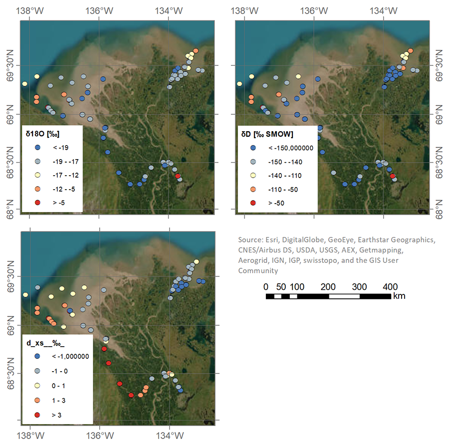
-
Temperature and salinity in the surface water during 4 expeditions from spring to fall in 2019, Mackenzie Delta Regio...
During Leg 1, the CTD (CTD RBR Maestro) was manually lowered in the water through an ice hole. During legs 2 to 4, the CTD (CTD RBR Concerto) was installed on a Seabird...
-
Hydrographic (CTD) profiles during 4 expeditions from spring to fall in 2019, Mackenzie Delta Region (CA)
During Leg 1, the CTD (CTD RBR Maestro) was manually lowered in the water through an ice hole with a velocity of less than 0.3 ms-1 and an acquisition frequency of 6 Hz,...
