  • Log in
Arctic Permafrost Geospatial Centre
    • Datasets
    • Categories
    • Projects
    • Collections
    • درباره
    • Map
  1. Home
  2. Collections
  3. AMPAC-Net Spatial Models
ampac-spatial-models

AMPAC-Net Spatial Models

This dataset collection is a data type subset of the AMPAC-Net project and contains spatially-explict (e.g. gridded) methane emissions from different process-based models. read more

Datasets
6

Regions

  • >45 °N (1)

Products

  • gridded maps of... (1)

Sensors

  • eddy covariance,... (1)

Spatial Resolution

  • 0.5° - 1° (1)

Temporal Resolution

  • Monthly (1)

Keywords

  • Eddy Covariance (1)
  • Emissions (1)
  • Methane (1)
  • upscaling (1)
  • Wetland (1)

Data Formats

  • NetCDF (1)

First Authors

  • Olli Peltola (1)

Projects

  • AMPAC-Net Spatial Models (1)
  • Arctic Methane and... (1)
  • Biogeochemistry (1)

Institutes

  • Finnish... (1)

Publishers

  • zenodo (1)

close
  • Datasets
  • Members
  • درباره
  • Activity Stream

1 dataset found

Institutes: Finnish Meteorological Institute

Filter Results
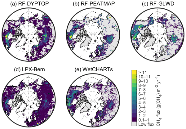
  • Gridded monthly methane emissions from terrestrial wetlands, north of 45 °N, 2013-2014

    This dataset provides wetland methane (CH4) emissions, their uncertainties and underlying CH4 flux densities north from 45 N using three different wetland maps. The data...
    • NetCDF
  • About Arctic Permafrost Geospatial Centre
  • CKAN API
  • Open Knowledge Foundation

  • Powered by CKAN

Initiated by

Provided by

Imprint | Privacy Notice