-
Point Pedon Data of the Northern Circumpolar Soil Carbon Database, Circum-Arctic
The Northern Circumpolar Soil Carbon Database version 2 (NCSCDv2) is a geospatial database created for the purpose of quantifying storage of organic carbon in soils of the...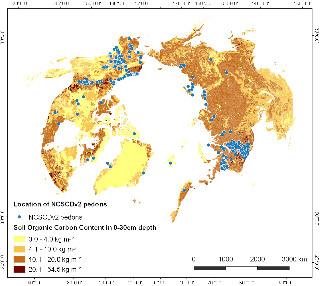
-
Lake Ice Classification from Sentinel-1, 2015-2016, Teshekpuk, Alaska (US)
Weekly lake ice classifications distinguish grounded ice and floating ice in lakes based on Sentinel-1A and Sentinel-1B synthetic aperture radar time-series with a resolution of...
-
Vegetation Height from Sentinel-1 and Sentinel-2, Kytalyk, 2016-2018, Central Yakutia (RU)
Vegetation height has been derived from Sentinel-1 satellite data acquired in VV mode with a resolution of 20 m. Vegetation height was estimated using an empirical model on...
-
Rockglacier and Slope Instability Inventory from differential SAR interferograms and optical imagery, 1998-2016, Broo...
Rockglaciers and other periglacial processes were mapped using visual analysis of differential SAR interferograms and satellite optical images (Google Satellite, Bing Aerial)...
-
Lake Ice Classification from Sentinel-1, 2016-2017, Central Seward Peninsula, Alaska (US)
Lake ice classifications distinguish grounded ice and floating ice in lakes based on Sentinel-1A and Sentinel-1B synthetic aperture radar time-series with a resolution between...
-
Lake Ice Classification from Sentinel-1, 2016-2017, Cape Espenberg Lowland, Alaska (US)
Lake ice classifications distinguish grounded ice and floating ice in lakes based on Sentinel-1A and Sentinel-1B synthetic aperture radar time-series with a resolution between...
-
Vegetation Height from Sentinel-1 and Sentinel-2, 2016-2018, Teshekpuk, Arctic Alaska (US)
Vegetation height has been derived from Sentinel-1 satellite data acquired in VV mode with a resolution of 20 m. Vegetation height was estimated using an empirical model on...
-
Footprints of MACS aerial images from POLAR 6 ThawTrend_Air_2019 flight campaign in northern Alaska (US)
This datasets contains the footprints of the DLR MACS (Modular Aerial Camera System) acquisitions (RGB + NIR) during the AWI ThawTrendAir2019 campaign on POLAR 6 from 10 July...
-
Vegetation Height from Sentinel-1 and Sentinel-2, 2015-2018, Seward peninsula, Alaska (US)
Vegetation height has been derived from Sentinel-1 satellite data acquired in VV mode with a resolution of 20 m. Vegetation height was estimated using an empirical model on...
-
Vegetation Height from Sentinel1 and Sentinel-2, 2016-2018, Barrow, Alaska (US)
Vegetation height has been derived from Sentinel-1 satellite data acquired in VV mode with a resolution of 20 m. Vegetation height was estimated using an empirical model on...
-
Vegetation Height from Sentinel-1 and Sentinel-2, 2016-2018, Toolik, Alaska (US)
Vegetation height has been derived from Sentinel-1 satellite data acquired in VV mode with a resolution of 20 m. Vegetation height was estimated using an empirical model on...
-
Vegetation Height from Sentinel-1 and Sentinel-2, 2016-2018, Mackenzie Delta, Beaufort Sea Region (CA)
Vegetation height has been derived from Sentinel-1 satellite data acquired in VV mode with a resolution of 20 m. Vegetation height was estimated using an empirical model on...
-
Vegetation Height from Sentinel-1 and Sentinel-2, 2016-2018, Umiuaq, Quebec-Labrador (CA)
Vegetation height has been derived from Sentinel-1 satellite data acquired in VV mode with a resolution of 20 m. Vegetation height was estimated using an empirical model on...
-
Vegetation Height from Sentinel-1 and Sentinel-2, 2016-2018, Lena Delta, Laptev and East Siberian Sea Region (RU)
Vegetation height has been derived from Sentinel-1 satellite data acquired in VV mode with a resolution of 20 m. Vegetation height was estimated using an empirical model on...
-
Vegetation Height from Sentinel-1 and Sentinel-2, 2016-2018, Western Siberia (RU)
Vegetation height has been derived from Sentinel-1 satellite data acquired in VV mode with a resolution of 20 m. Vegetation height was estimated using an empirical model on...
-
Mapped thermokarst ice wedge polygon patterns from GeoEye-1, 2009, Buor Khaya, Laptev Sea coast, Siberia (RU)
Detailed calculations of ground-ice volumes in permafrost deposits are necessary to understand and quantify the response of permafrost landscapes to thermal disturbance and...
-
Surface Water Area from sub-meter resolution Satellite Imagery, 2002-2019, Kotzebue, Northwestern Baldwin Peninsula A...
Arctic landscapes are in a state of transition due to changes in climate occurring during both the summer and winter seasons. Scattered observations indicate that beavers...
-
Submarine Permafrost Map (SuPerMAP), modeled with CryoGrid 2, Circum-Arctic
This data set contains a first‐order estimate of distribution, thickness and ice-content of submarine permafrost on the Arctic shelf based on a numerical heat transfer model....
-
Ground Temperature Map, 2000-2017, Antarctic
The product provides modeled mean annual ground temperatures (MAGT) at the top of the permafrost for Antarctica and Subantarctic islands at 1 km spatial resolution. Permafrost...
-
Ground Temperature Map, 2000-2016, Andes
The product provides modeled mean annual ground temperatures (MAGT) at the top of the permafrost for Andes at 1 km spatial resolution. Permafrost probability (fraction values...
