-
Mapped polygon pattern geomorphometry from HRSC-AX, 2009, AD2 Adventdalen, Svalbard (NO)
Polygonal systems formed by thermal contraction cracking are complex landscape features widespread in terrestrial periglacial regions. The manner in which cracking occurs is...
-
Mapped polygon pattern geomorphometry from HRSC-AX, 2009, Act-IWS Adventdalen, Svalbard (NO)
Polygonal systems formed by thermal contraction cracking are complex landscape features widespread in terrestrial periglacial regions. The manner in which cracking occurs is...
-
Mapped polygon pattern geomorphometry from HRSC-AX, 2009, Isdammen Adventdalen, Svalbard (NO)
Polygonal systems formed by thermal contraction cracking are complex landscape features widespread in terrestrial periglacial regions. The manner in which cracking occurs is...
-
Recovered Drained Thaw Lake Basins (DTLBs) from InSAR DEM and Remote Sensing Imagery, 2002-2010, Arctic Coastal Plain...
Paleoshorelines of Drained Thaw Lake Basins (DTLBs) on the Alaskan North Slope were mapped using the Interferometric Synthetic Aperture Radar Digital Elevation Model (InSAR DEM)...
-
Active layer depth map, 1960-1987, Yakutia, ASSR
The rasterized map of active layer depth of Yakutia, East Siberia, was derived based on the map of landscapes and permafrost conditions in Yakutia (Merzlotno-landshaftnaya karta...
-
Robust trends of landscape dynamics in the Arctic Lena Delta with temporally dense Landsat time-series stacks
The robust Theil-Sen regression algorithm was used to calculate trend parameters (slope, intercept, confidence intervals) on Landsat time-series stack in the north-east Siberian...
-
Northern Circumpolar Soil Carbon Database, Russia, geotiff- and netCDF-files
The Northern Circumpolar Soil Carbon Database version 2 (NCSCDv2) is a geospatial database created for the purpose of quantifying storage of organic carbon in soils of the...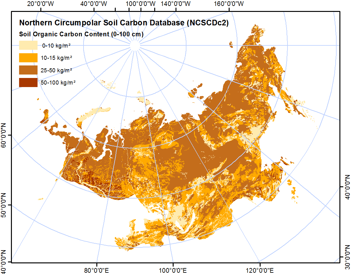
-
Mapped thermokarst ice wedge polygon patterns from GeoEye-1, 2009, Buor Khaya, Laptev Sea coast, Siberia (RU)
Detailed calculations of ground-ice volumes in permafrost deposits are necessary to understand and quantify the response of permafrost landscapes to thermal disturbance and...
-
Submarine Permafrost Map (SuPerMAP), modeled with CryoGrid 2, Circum-Arctic
This data set contains a first‐order estimate of distribution, thickness and ice-content of submarine permafrost on the Arctic shelf based on a numerical heat transfer model....
-
Northern Circumpolar Soil Carbon Database, Svalbard, geotiff- and netCDF-files
The Northern Circumpolar Soil Carbon Database version 2 (NCSCDv2) is a geospatial database created for the purpose of quantifying storage of organic carbon in soils of the...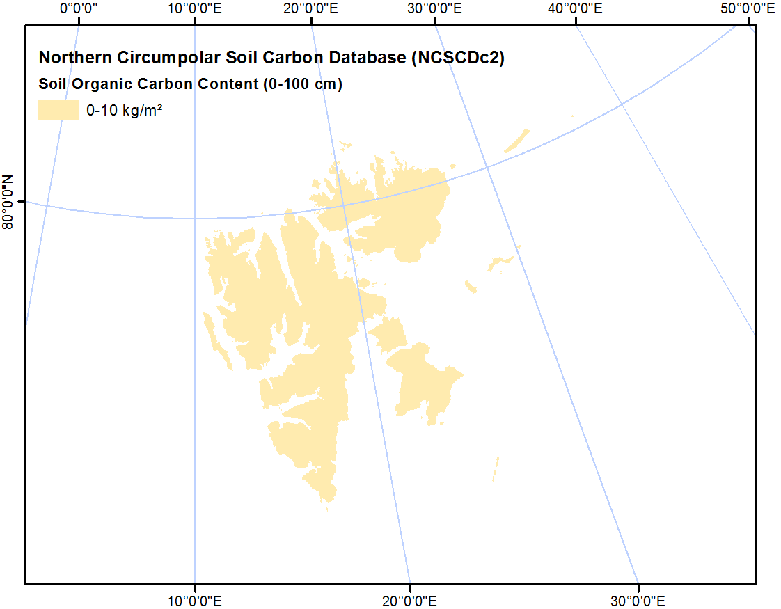
-
Northern Circumpolar Soil Carbon Database, Mongolia, geotiff- and netCDF-files
The Northern Circumpolar Soil Carbon Database version 2 (NCSCDv2) is a geospatial database created for the purpose of quantifying storage of organic carbon in soils of the...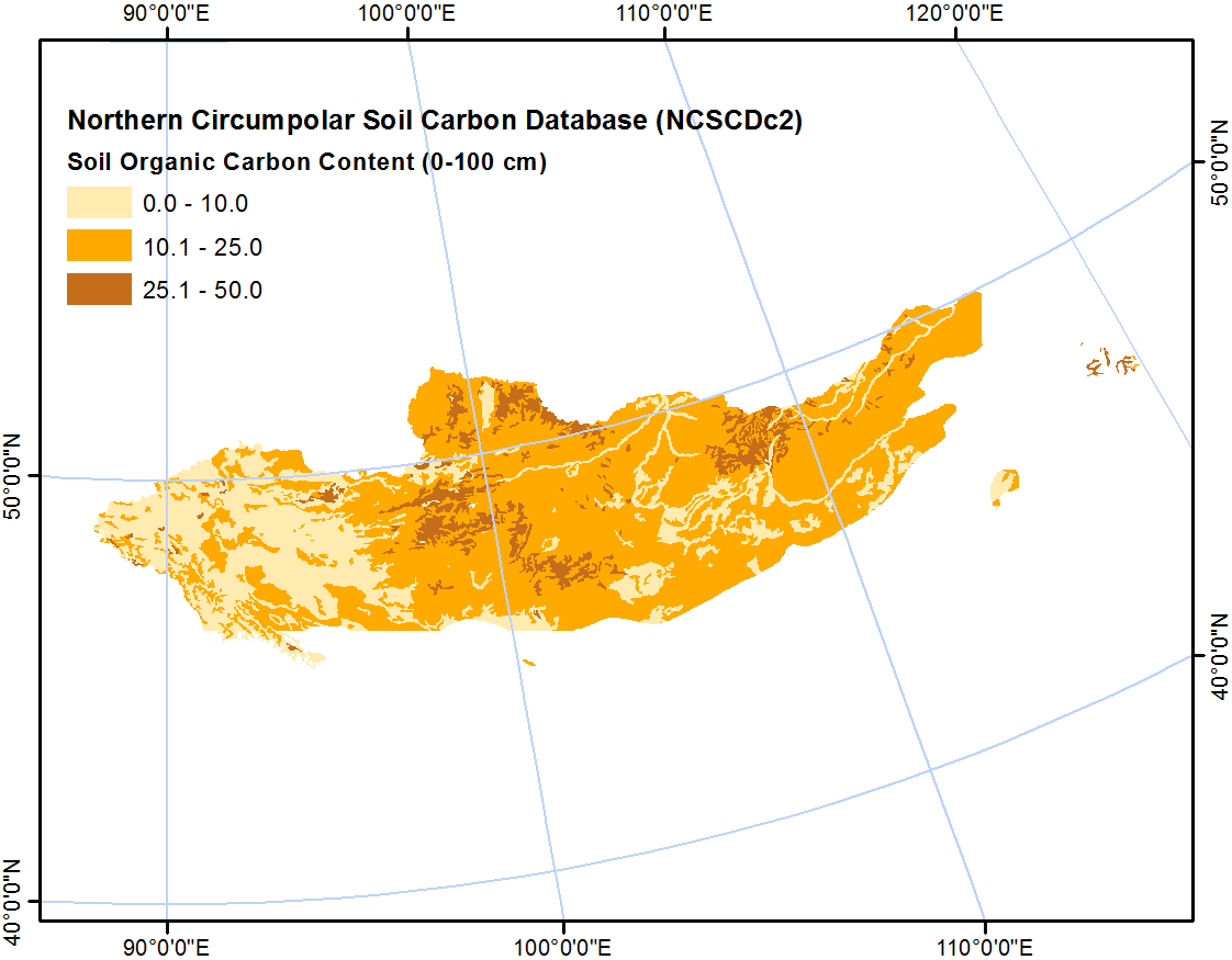
-
Northern Circumpolar Soil Carbon Database, Kazaksthan, geotiff- and netCDF-files
The Northern Circumpolar Soil Carbon Database version 2 (NCSCDv2) is a geospatial database created for the purpose of quantifying storage of organic carbon in soils of the...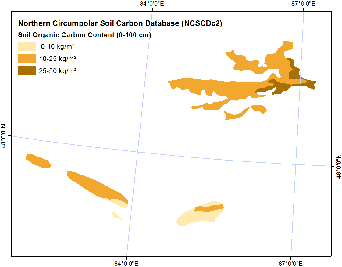
-
Northern Circumpolar Soil Carbon Database, Iceland, geotiff- and netCDF-files
The Northern Circumpolar Soil Carbon Database version 2 (NCSCDv2) is a geospatial database created for the purpose of quantifying storage of organic carbon in soils of the...
-
Northern Circumpolar Soil Carbon Database, Greenland, geotiff- and netCDF-files
The Northern Circumpolar Soil Carbon Database version 2 (NCSCDv2) is a geospatial database created for the purpose of quantifying storage of organic carbon in soils of the...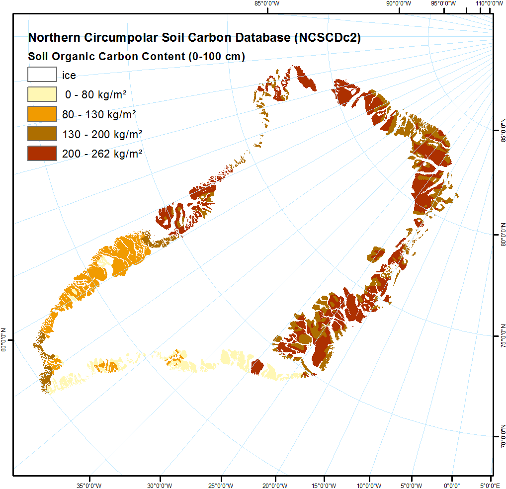
-
Northern Circumpolar Soil Carbon Database, Europe, geotiff- and netCDF-files
The Northern Circumpolar Soil Carbon Database version 2 (NCSCDv2) is a geospatial database created for the purpose of quantifying storage of organic carbon in soils of the...
-
Northern Circumpolar Soil Carbon Database, Conusus, geotiff- and netCDF-files
The Northern Circumpolar Soil Carbon Database version 2 (NCSCDv2) is a geospatial database created for the purpose of quantifying storage of organic carbon in soils of the...
-
Northern Circumpolar Soil Carbon Database, Circum-Arctic Region, netCDF-files
The Northern Circumpolar Soil Carbon Database version 2 (NCSCDv2) is a geospatial database created for the purpose of quantifying storage of organic carbon in soils of the...
-
Northern Circumpolar Soil Carbon Database, Circum-Arctic Region, geotiff-files
The Northern Circumpolar Soil Carbon Database version 2 (NCSCDv2) is a geospatial database created for the purpose of quantifying storage of organic carbon in soils of the...
-
Northern Circumpolar Soil Carbon Database, Canada, geotiff- and netCDF-files
The Northern Circumpolar Soil Carbon Database version 2 (NCSCDv2) is a geospatial database created for the purpose of quantifying storage of organic carbon in soils of the...
-
Frozen State Backscatter Intensity from Sentinel-1, 2015-2016, West Siberia (RU)
Frozen state backscatter intensity was derived from Sentinel-1 acquisitions from December 2015 and 2016. By excluding the effects of liquid water content (acquisitions under...
