-
Potential Future Lake Drainage from an IfSAR-Derived Digital Surface Model, 2002-2003, Western Arctic Coastal Plain, ...
Assessment of lakes for their future potential to drain relied on the 2002/03 airborne Interferometric Synthetic Aperture Radar (IFSAR) Digital Surface Model (DSM) data for the...
-
Polygonal Tundra Geomorphology Map from Landsat time series, 2014, Alaskan Arctic Coastal Plain (US)
We mosaicked twelve LandSat-8 OLI satellite images taken during the summer of 2014, which were used in an object based image analysis (OBIA) to classify the landscape. We mapped...
-
NDVI trend from Landsat time series, 1999-2014, Alaskan Arctic Coastal Plain (US)
Normalized difference vegetation index (NDVI) trend map was computed for the Alaskan Arctic Coastal Plain between 1999 and 2014. The decadal trend of each pixel was computed...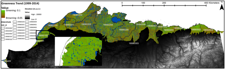
-
Trend analysis of lake dynamics from Landsat time-series 1999-2014, Alaska North Slope, Alaska (US)
The dataset was created with a methodology based on machine-learning based classification of robust trends of multi-spectral indices of Landsat data (TM,ETM+, OLI) and...
-
Trend analysis of lake dynamics from Landsat time-series 1999-2014, Kolyma Lowland, Siberia (RU)
The dataset was created with a methodology based on machine-learning based classification of robust trends of multi-spectral indices of Landsat data (TM,ETM+, OLI) and...
-
Trend analysis of lake dynamics from Landsat time-series 1999-2014, Central Yakutia, Siberia (RU)
The dataset was created with a methodology based on machine-learning based classification of robust trends of multi-spectral indices of Landsat data (TM,ETM+, OLI) and...
-
Trend analysis of lake dynamics from Landsat time-series 1999-2014, Kobuk-Selawik-Lowlands, Alaska (US)
The dataset was created with a methodology based on machine-learning based classification of robust trends of multi-spectral indices of Landsat data (TM,ETM+, OLI) and...
-
Ground ice maps from paleogeographic modelling approach, Canada (CA)
Ground ice melt caused by climate-induced permafrost degradation may trigger significant ecological change, damage infrastructure, and alter biogeochemical cycles. The...
-
Circumpolar raster grids of permafrost extent and geohazard potential for near-future climate scenarios
One of the consequences of warming climate is rising ground temperatures and degradation of perennially frozen ground, permafrost. Thawing of near-surface permafrost can cause...
-
Remotely-sensed Arctic Discharge Reanalysis (RADR) from discharge observations and Landsat, 1984-2018, Circum-Arctic
Arctic rivers drain ~15% of the global land surface and significantly influence local communities and economies, freshwater and marine ecosystems, and global climate. However,...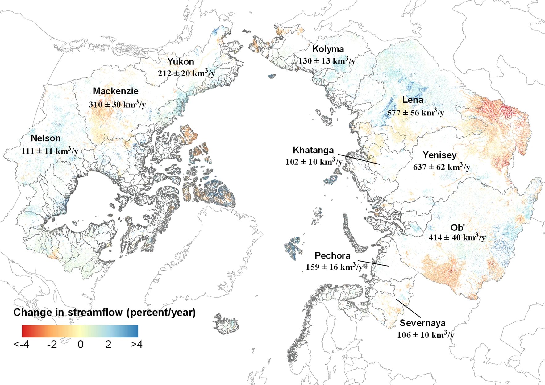
-
Quantification of shoreline movements from satellite remote sensing, 1951-2011, Yukon Territory mainland coast (CA)
The Arctic is warming, but the impacts on its coasts are not well documented. To better understand the reaction of Arctic coasts to increasing environmental pressure, shoreline...
-
Permafrost active layer thickness for the Northern Hemisphere, v3.0 from MODIS LST, ERA5, 1997-2019
This dataset contains permafrost active layer thickness data produced as part of the European Space Agency's (ESA) Climate Change Initiative (CCI) Permafrost project. It forms...
-
Permafrost active layer thickness for the Northern Hemisphere, v2.0 from MODIS LST, ERA5, 1997-2018
This dataset contains permafrost active layer thickness data produced as part of the European Space Agency's (ESA) Climate Change Initiative (CCI) Permafrost project. It forms...
-
Permafrost ground temperature for the Northern Hemisphere, v2.0 from MODIS LST, ERA5, 1997-2018
This dataset contains permafrost ground temperature data produced as part of the European Space Agency's (ESA) Climate Change Initiative (CCI) Permafrost project. It forms part...
-
Permafrost extent for the Northern Hemisphere, v2.0 from MODIS LST, ERA5, 1997-2018
This dataset contains permafrost extent data produced as part of the European Space Agency's (ESA) Climate Change Initiative (CCI) Permafrost project. It forms part of the first...
-
Annual dynamics of rapid permafrost disturbances from Landsat and Sentinel-2, 2000-2019, Northeast Siberia (RU)
Permafrost is warming globally which leads to widespread permafrost thaw. Particularly ice-rich permafrost is vulnerable to rapid thaw and erosion, impacting whole landscapes...
-
Coastal Retrogressive Thaw Slumps from GeoEye-1, WorldView-2 and Aerial Photographs, 2011, Yukon Coast (CA)
Coastal retrogressive thaw slumps (RTSs) were manually digitized at a 1:2000 scale using ArcMap (ESRI, version 10.3) from high‐resolution satellite images acquired in July (13...
-
Remote sensing-based permafrost region disturbances: lakes, 1999-2014, Eastern Canada (CA)
The data quantify the abundance and distribution of the permafrost region disturbance (PRD) of lakes and their dynamics, using trend analyses of 30-m-resolution Landsat imagery...
-
Remote sensing-based permafrost region disturbances: fire, 1999-2015, Eastern Canada (CA)
The data quantify the abundance and distribution of the permafrost region disturbance (PRD) wildfire, using trend analyses of 30-m-resolution Landsat imagery from 1999-2015 and...
-
Remote sensing-based permafrost region disturbances: retrogressive thaw slumps, 1999-2014, Alaska (US)
The data quantify the abundance and distribution of the permafrost region disturbance (PRD) of retrogressive thaw slumps, using trend analyses of 30-m-resolution Landsat imagery...
