-
Population in the Arctic Circumpolar Permafrost Region at settlement level, 2017
We defined permafrost settlements as settlements located within the permafrost extent, as modelled by Obu et al. (2019). The permafrost extent is based on...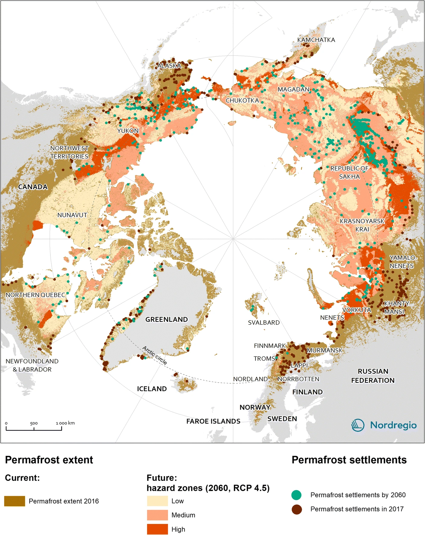
-
Settlements located within the permafrost extent in the Arctic Circumpolar Permafrost Region, 2017
We defined permafrost settlements as settlements located within the permafrost extent, as modelled by Obu et al. (2019). The permafrost extent is based on... -
Global-Gridded Daily Methane Emissions from Lake Systems, 2003-2015
This dataset provides global gridded information on lake surface area and open water CH4 emissions at a resolution of 0.25-degree x 0.25-degree for an annual climatology...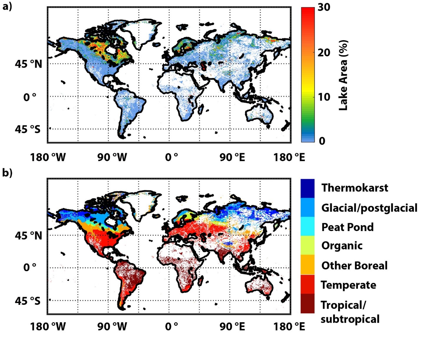
-
BAWLD-CH4: Methane Fluxes from Boreal and Arctic Ecosystems, 1984-2019, Pan-Arctic
These are the data files for the Boreal-Arctic Wetland and Lake Database methane (CH4) flux dataset (BAWLD-CH4). The dataset is a synthesis of reported methane fluxes from...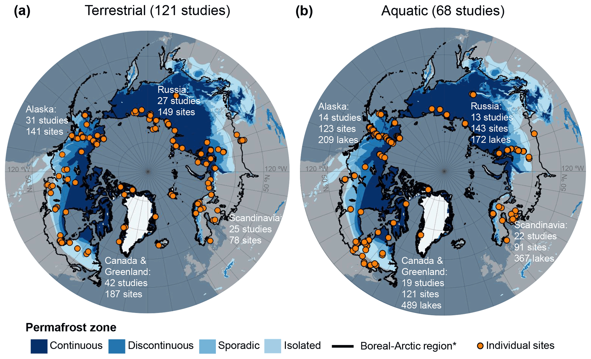
-
Dissolved methane and hydrochemical parameters in ice cores from 2017, Bykovsky Peninsula, Lena Delta
Data were analyzed to study the role of an winter ice cover for methane cycles of three different stages in the lake-lagoon-shelf transition in a region of rapidly thawing...
-
SAR-based Methane Ebullition Flux from Lakes, Five Regions, Alaska, 2007-2010
This dataset provides Synthetic Aperture Radar (SAR) estimates of lake-source methane ebullition flux in mg CH4/m2/d for thousands of lakes in five regions across Alaska. The...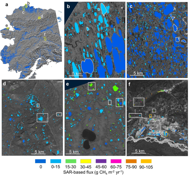
-
Quaternary deposits map of Yana-Indigirka and Kolyma lowlands tundra zone, R-55-57, based on Landsat imagery
The Quaternary geology map was created for the Yana-Indigirka (eastern part) and Kolyma lowlands, tundra and partly forest-tundra zones. The map corresponds to the nomenclature...
-
Gridded monthly methane emissions from terrestrial wetlands, north of 45 °N, 2013-2014
This dataset provides wetland methane (CH4) emissions, their uncertainties and underlying CH4 flux densities north from 45 N using three different wetland maps. The data...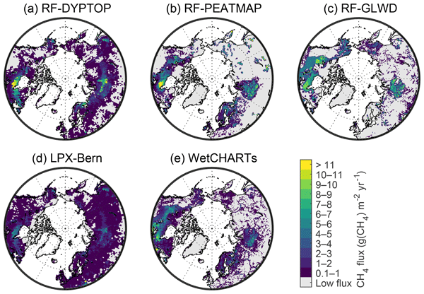
-
Database of Ice-Rich Yedoma Permafrost (IRYP)
We synthesized data on the circum-Arctic and sub-Arctic distribution and thickness of Yedoma for compiling a preliminary circum-polar Yedoma map. For compiling this map, we used...
-
Northern Circumpolar Soil Carbon Database, Alaska, geotiff- and netCDF-files
The Northern Circumpolar Soil Carbon Database version 2 (NCSCDv2) is a geospatial database created for the purpose of quantifying storage of organic carbon in soils of the...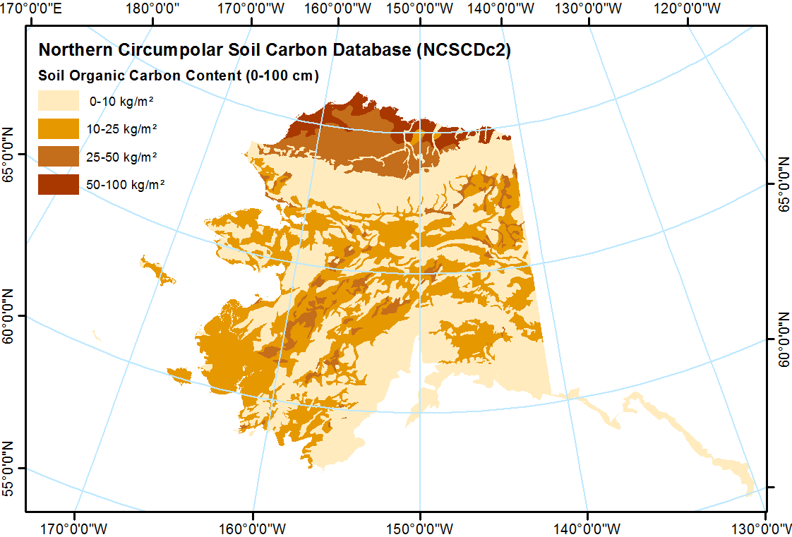
-
ABoVE: Lake and Wetland Classification from L-band SAR, Alaska and Canada, 2017-2019
This dataset contains a high-resolution land cover classification focused on water and wetland vegetation classes over three NASA ABoVE Campaign regions: Yukon Flats, Alaska,...
-
Global methane column-averaged dry air mole fraction (XCH4) from TROPOMI WFM-DOAS, since 2017
Carbon monoxide (CO) is an important atmospheric constituent affecting air quality, and methane (CH4) is the second most important greenhouse gas contributing to human-induced...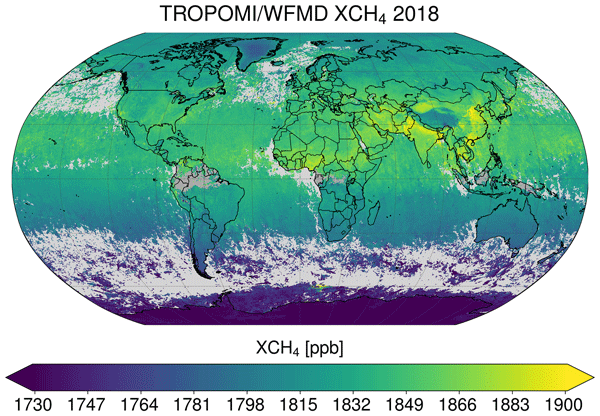
-
Eddy covariance measurements of methane flux from freshwater wetlands, 2006-2018, Global
FLUXNET-CH4 is an initiative led by the Global Carbon Project, in close partnership with AmeriFlux and EuroFlux, to compile a global database of eddy covariance (EC) methane...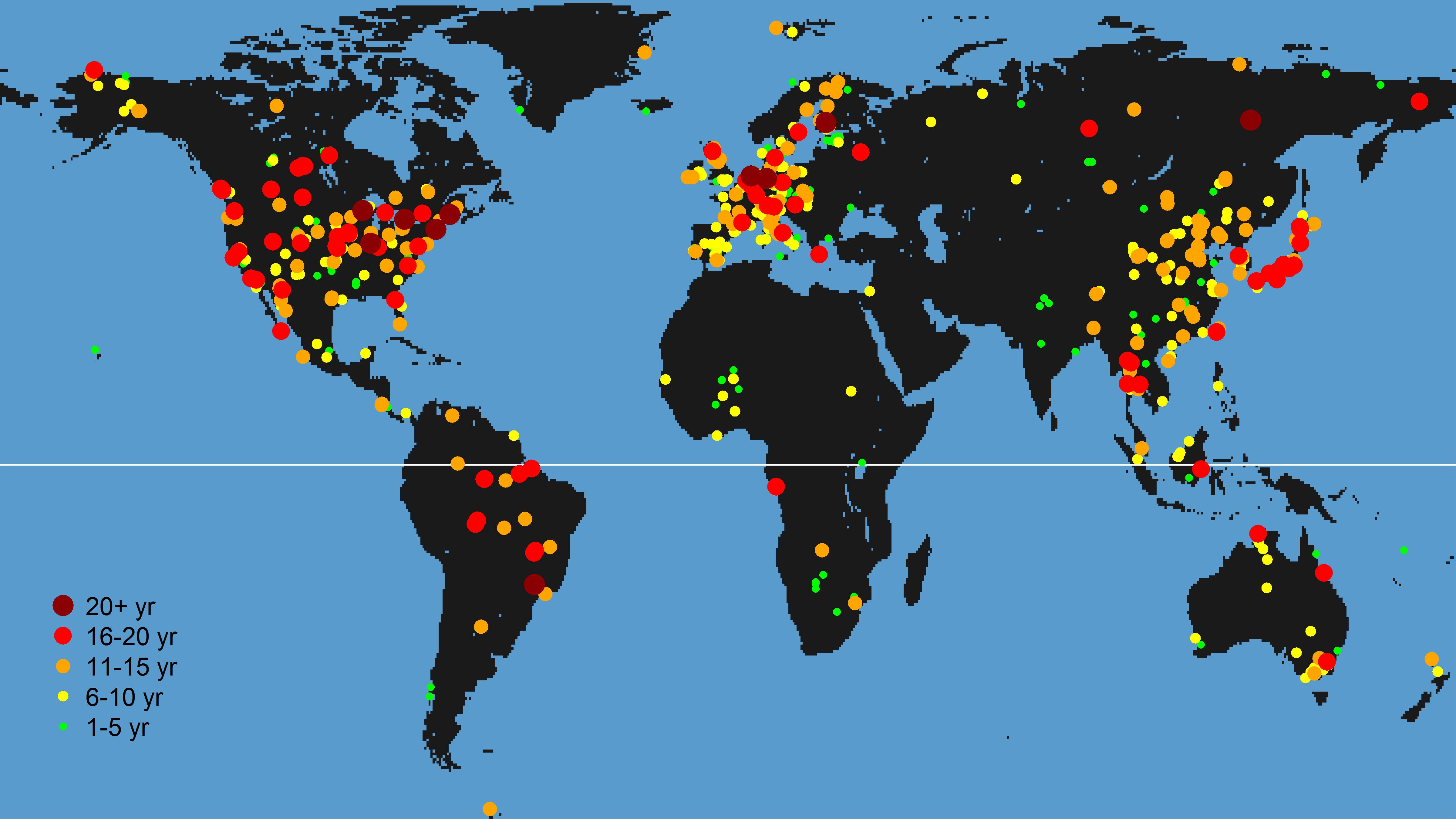
-
Methane and nitrous oxide sea-air fluxes calculated from samples collected in the North American Arctic Ocean (2015–2...
This dataset contains methane and nitrous oxide dissolved gas concentration, dissolved methane carbon isotope, and ancillary hydrographic data from research cruises in the North...
-
Chamber measured methane transport through individual aerenchymous plants at a boreal fen and a bog
The presented dataset contains chamber measurements of methane transport (mg CH₄ g dry plant mass-1 day-1) through individual aerenchymous peatland plants and the ancillary data...
-
ABoVE: Atmospheric Gas Concentrations from Airborne Flasks, Arctic-CAP, 2017
This dataset provides atmospheric carbon dioxide (CO2), methane (CH4), carbon monoxide (CO), molecular hydrogen (H2), nitrous oxide (N2O), sulfur hexafluoride (SF6), and other...
-
ABoVE: Atmospheric Profiles of CO, CO2 and CH4 Concentrations from Arctic-CAP, 2017
This dataset provides in situ airborne measurements of atmospheric carbon monoxide (CO), carbon dioxide (CO2), methane (CH4), and water vapor concentrations, plus air... -
ABoVE/ASCENDS: Active Sensing of CO2, CH4, and Water Vapor, Alaska and Canada, 2017
This dataset provides in situ airborne measurements of atmospheric carbon dioxide (CO2), methane (CH4), and water vapor concentrations, plus air temperature, pressure, relative...
-
Gridded inventory of Canada's anthropogenic methane emissions for 2018
This dataset contains a gridded inventory of Canada's 2018 anthropogenic methane emissions at 0.1 x 0.1 degree. National and provincial emission totals in the inventory match...
-
Incubation data, Carbon flux data and soil properties of thaw slump soils on Kurungnakh, Lena Delta, 2016 & 2019
The dataset comprises in situ CO2 and CH4 fluxes, active layer depths, thawed carbon pools and soil temperatures from different non-vegetated soils in an active thaw slump in...
