-
Population in the Arctic Circumpolar Permafrost Region at settlement level, 2017
We defined permafrost settlements as settlements located within the permafrost extent, as modelled by Obu et al. (2019). The permafrost extent is based on...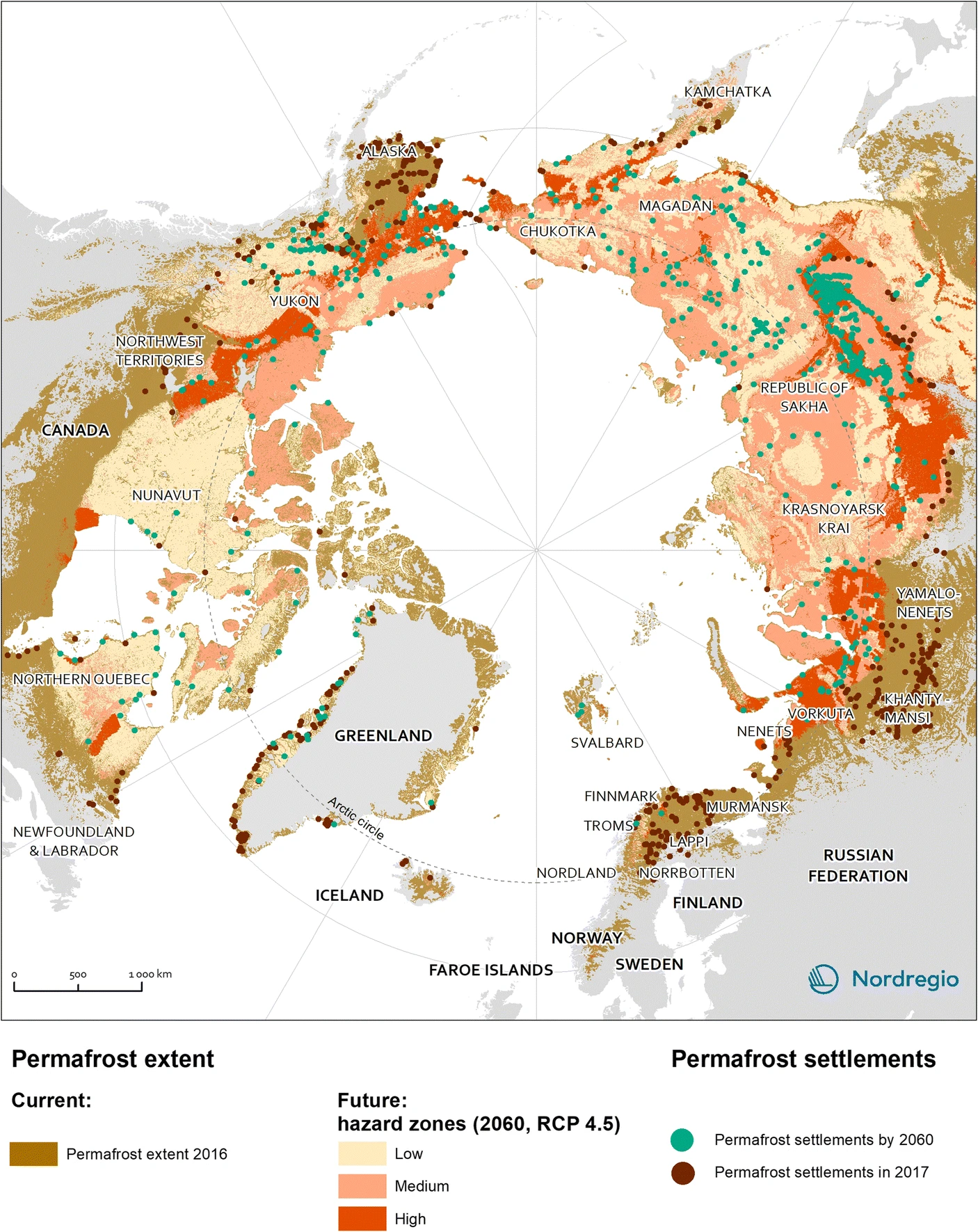
-
Settlements located within the permafrost extent in the Arctic Circumpolar Permafrost Region, 2017
We defined permafrost settlements as settlements located within the permafrost extent, as modelled by Obu et al. (2019). The permafrost extent is based on... -
Pingo Database, 2022, Svalbard (NO)
The data contains the list of pingo and pingo-like forms over Svalbard archipelago. Each pingo is assigned with following data: coordinates, absolute height of pingo baseline,...
-
Inorganic and organic hydrochemistry of lakes and ponds in continuous permafrost landscapes in the western Canadian A...
Between 2006 and 2015 inorganic and organic hydrochemical parameters and stable water isotope characteristics were measured in lakes and ponds in continuous permafrost...
-
Holocene vegetation dynamics of circum-Arctic permafrost peatlands
Vegetation shifts in circum-Arctic permafrost peatlands drive feedbacks with important consequences for peatland carbon budgets and the extent of permafrost thaw under changing...
-
Detailed pedon data on soil carbon and nitrogen for the northern permafrost region
Soils in the northern high latitudes are a key component in the global carbon cycle; the northern permafrost region covers 22% of the Northern Hemisphere and holds almost twice...
-
Aufeis (naleds) from 1958 historical maps and 2013-2017 Landsat-8 OLI images, Indigirka River basin, Siberia (RU)
The GIS database contains the data of aufeis (naleds) in the Indigirka River basin (Russia) from historical and nowadays sources, and complete ArcGIS 10.1/10.2 and Qgis 3*...
-
Aufeis (naleds) from 1958 historical maps and 2013-2019 Landsat-8 OLI images, Chukotka region, Siberia (RU)
The GIS database contains the data of aufeis (naled) in the Chukotka region from historical and nowadays sources, and complete ArcGIS 10.1/10.2 and Qgis 3* projects to view and...
-
Aufeis (naleds) from 1958 historical maps and 2013-2017 Landsat-8 OLI images, Kolyma River basin, Siberia (RU)
The GIS database contains the data of aufeis (naleds) in the Kolyma River basin (Russia) from historical and nowadays sources, and complete ArcGIS 10.1/10.2 and Qgis 3* projects...
-
Content of carbon isotopes (¹³C and ¹⁴C) in organic carbon pools in terrestrial Siberia
The dataset consists of one xlsx file with four sheets, listing (1) ¹³C and ¹⁴C data of litter and organic layers in northern Russia, Scandinavia, Canada and Alaska; (2) ¹³C and...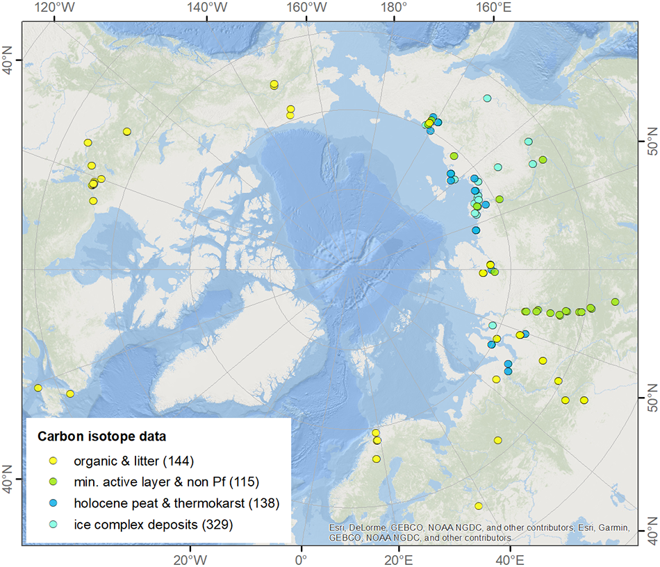
-
Lake-DOC Database (PeRL-DOCv1), 1979-2017, Permafrost-Region
The pan-Arctic Permafrost-Region Lake-DOC version1 database contains surface water samples of lakes in the permafrost regions of Alaska (49.3 %), Canada (24.2 %), Greenland (3.2...
-
Historic Lake Drainage from Remote Sensing Datasets, 1955-2017, Western Arctic Coastal Plain, Northern Alaska (US)
We identified all lakes larger than 10 hectares (ha) that drained completely or partially (greater than 25 %) between 1955 and 2017 using historical (original) USGS topographic...
-
Distribution of pingos from an IfSAR digital surface model, 2002-2006, western Arctic Coastal Plain, Northern Alaska ...
A detailed attributed point feature shapefile of 1247 pingo locations was manually assembled from a 5m resolution digital surface model (DSM) derived from an airborne...
-
Distribution of pingos from topographic maps, permafrost region, Siberia (RU)
A detailed attributed point feature shapefile of 6059 pingo locations in a 3.5 × 10⁶ km² region of northern Asia was manually assembled from 1:200 000 scale Russian...
-
Near-surface permafrost conditions from synthesis data, 1997-2016, Alaska
We compiled a near-surface permafrost temperature dataset from 72 monitoring stations in Alaska using data collected by the U. S. Geological Survey, the National Park Service,...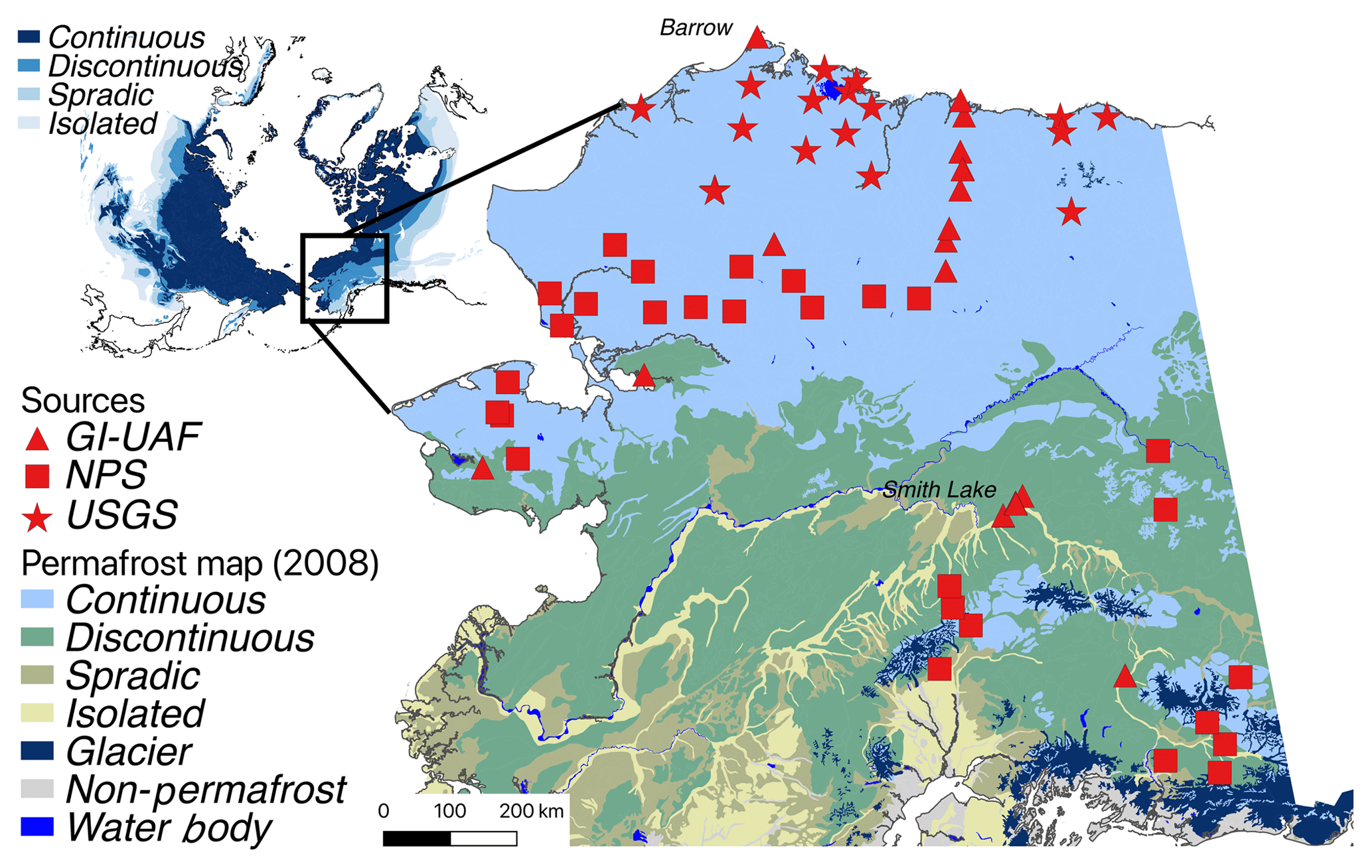
-
GTN-P (2015): Global Terrestrial Network for Permafrost metadata for permafrost boreholes (TSP) and active layer moni...
The Global Terrestrial Network for Permafrost (GTN-P) provides the first dynamic database associated with the Thermal State of Permafrost (TSP) and the Circumpolar Active Layer...
-
Aufeis (naleds) from 1958 historical maps and 2013-2017 Landsat-8 OLI images, Yana River basin, Siberia (RU)
The GIS database contains the data of aufeis (naled) in the Yana River basin (Russia) from historical and nowadays sources, and complete ArcGIS 10.1/10.2 and Qgis 3* projects to...
-
Point Pedon Data of the Northern Circumpolar Soil Carbon Database, Circum-Arctic
The Northern Circumpolar Soil Carbon Database version 2 (NCSCDv2) is a geospatial database created for the purpose of quantifying storage of organic carbon in soils of the...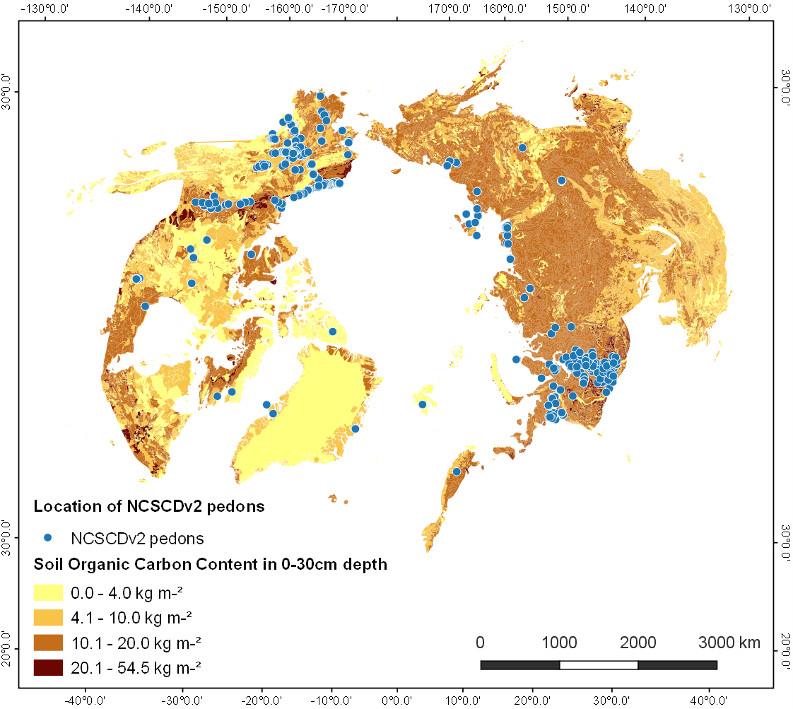
-
Lake Basal Ages and Origins from scientific literature, Circum-Arctic
This dataset is a compilation of 1,207 lake basal ages used to identify spatial and temporal patterns of lake formation across the high northern latitudes. Data was gathered...
