-
The fractional land cover estimates from the Boreal–Arctic Wetland and Lake Dataset (BAWLD), 2021, Circum-Arctic
The Boreal and Arctic Wetland and Lake Dataset (BAWLD) provides estimates of fractional land cover of 19 land cover classes within 0.5° ×0.5° grid cells. The total area of the...
-
Historic Lake Drainage from Remote Sensing Datasets, 1955-2017, Western Arctic Coastal Plain, Northern Alaska (US)
We identified all lakes larger than 10 hectares (ha) that drained completely or partially (greater than 25 %) between 1955 and 2017 using historical (original) USGS topographic...
-
Potential Future Lake Drainage from an IfSAR-Derived Digital Surface Model, 2002-2003, Western Arctic Coastal Plain, ...
Assessment of lakes for their future potential to drain relied on the 2002/03 airborne Interferometric Synthetic Aperture Radar (IFSAR) Digital Surface Model (DSM) data for the...
-
Polygonal Tundra Geomorphology Map from Landsat time series, 2014, Alaskan Arctic Coastal Plain (US)
We mosaicked twelve LandSat-8 OLI satellite images taken during the summer of 2014, which were used in an object based image analysis (OBIA) to classify the landscape. We mapped...
-
NDVI trend from Landsat time series, 1999-2014, Alaskan Arctic Coastal Plain (US)
Normalized difference vegetation index (NDVI) trend map was computed for the Alaskan Arctic Coastal Plain between 1999 and 2014. The decadal trend of each pixel was computed...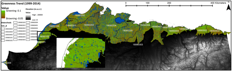
-
Permafrost active layer thickness for the Northern Hemisphere, v3.0 from MODIS LST, ERA5, 1997-2019
This dataset contains permafrost active layer thickness data produced as part of the European Space Agency's (ESA) Climate Change Initiative (CCI) Permafrost project. It forms...
-
Recovered Drained Thaw Lake Basins (DTLBs) from InSAR DEM and Remote Sensing Imagery, 2002-2010, Arctic Coastal Plain...
Paleoshorelines of Drained Thaw Lake Basins (DTLBs) on the Alaskan North Slope were mapped using the Interferometric Synthetic Aperture Radar Digital Elevation Model (InSAR DEM)...
