-
Database of Ice-Rich Yedoma Permafrost (IRYP)
We synthesized data on the circum-Arctic and sub-Arctic distribution and thickness of Yedoma for compiling a preliminary circum-polar Yedoma map. For compiling this map, we used...
-
Pan-Arctic Visualization of Landscape Change (2003-2022), Arctic PASSION Permafrost Service
This raster dataset, in Cloud Optimized GeoTIFF format (COG), provides information on land surface changes at the pan-arctic scale. Multispectral Landsat-5 TM, Landsat-7 ETM+,...
-
T-MOSAiC 2021 myThaw data set, Circum-Arctic
The Terrestrial Multidisciplinary distributed Observatories for the Study of the Arctic Connections (T-MOSAiC) 2021 permafrost thaw data set provides standardized measurements...
-
Inorganic and organic hydrochemistry of lakes and ponds in continuous permafrost landscapes in the western Canadian A...
Between 2006 and 2015 inorganic and organic hydrochemical parameters and stable water isotope characteristics were measured in lakes and ponds in continuous permafrost...
-
Ground layer above-ground biomass of 39 sites from 2018 central Chukotka (RU) - Raw data of dry weight for each sub-g...
Field investigations were performed in four areas: a treeless mountainous tundra (16-KP-04; Lake Rauchuagytgyn area), tundra-taiga transition zone (16-KP-01, Lake Ilirney area)...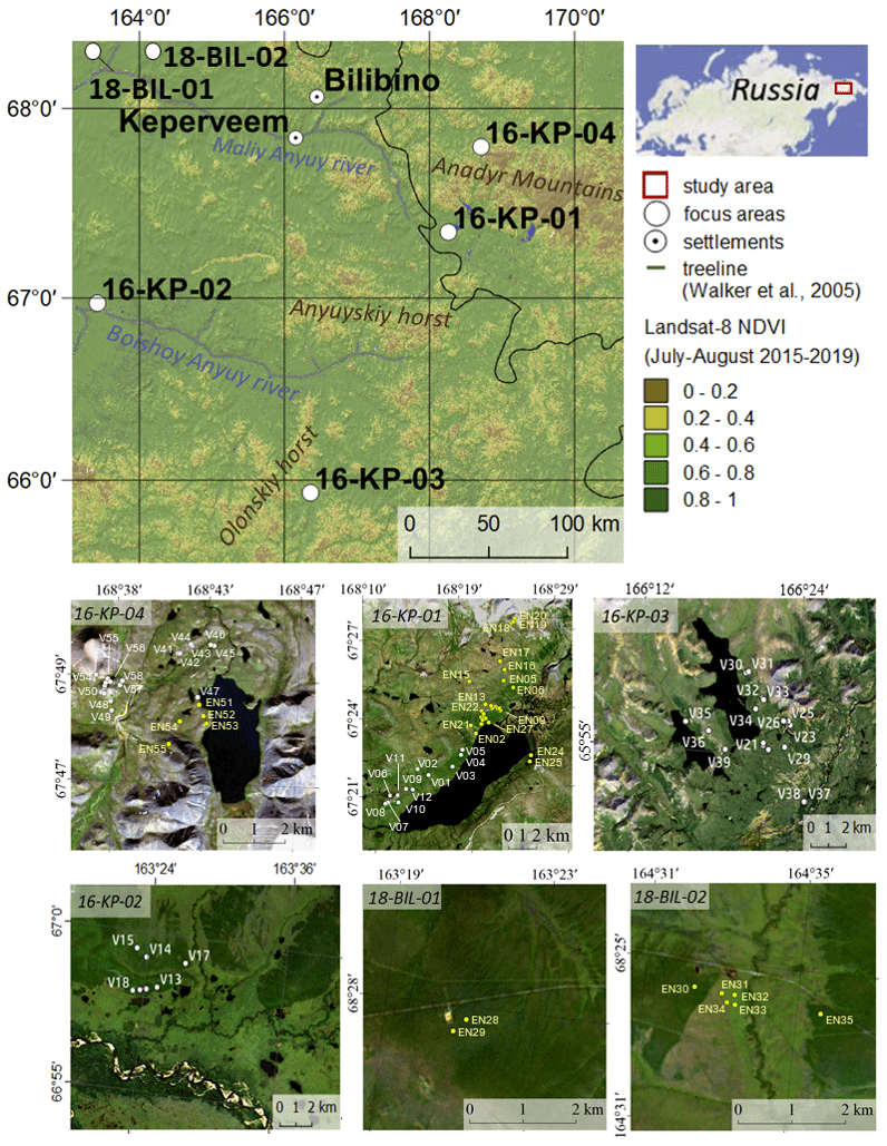
-
Ground layer above-ground biomass of 25 sites from 2018 central Lena Delta (RU) - Raw data of dry weight for each sub...
Field investigations were performed in the central Lena Delta. In total, 25 sites were investigated. The sites were chosen to represent a variety of vegetation communities of...
-
Stable water isotopes (δ18O, δD, d-excess) in the surface water during 4 expeditions from spring to fall in 2019, Mac...
Water samples for stable isotopes were collected untreated in 10 mL HDPE vials, sealed tightly, stored in the dark at 4°C. Measurements were conducted at the laboratory facility...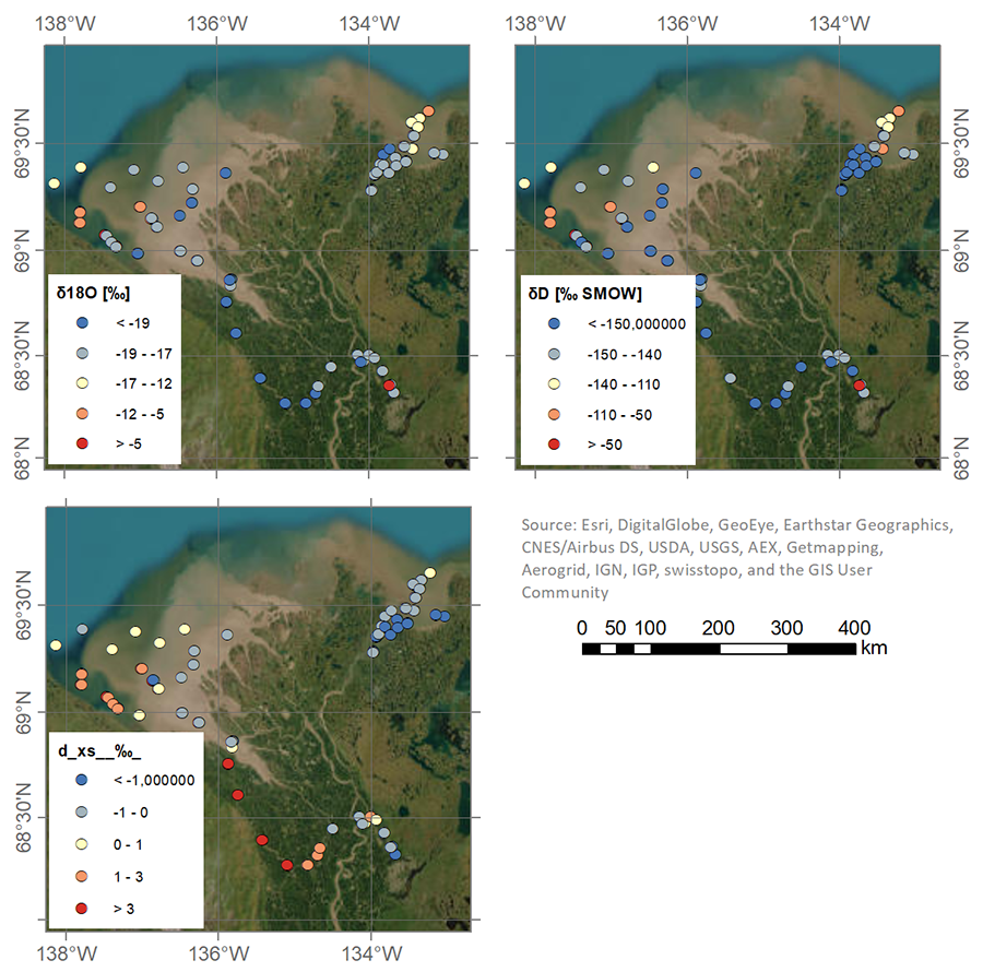
-
Dissolved organic carbon (DOC) concentration in the surface water during 4 expeditions from spring to fall in 2019, M...
Water samples were filtered through 0.7 µm GF/F filter, and acidified with 25 µL Suprapur HCl (10 M) on the same day of sampling. DOC samples were stored and kept at 4°C in the...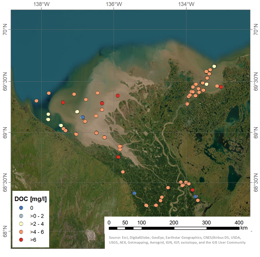
-
Vegetation map of Trail Valley Creek from airborne orthophotos, laser scanning and field work data, Northwest Territo...
The vegetation map distinguishes between five tundra vegetation types, trees, and open water at the forest-tundra transition north of Inuvik, Northwest Territories, Canada. The...
-
Lake-DOC Database (PeRL-DOCv1), 1979-2017, Permafrost-Region
The pan-Arctic Permafrost-Region Lake-DOC version1 database contains surface water samples of lakes in the permafrost regions of Alaska (49.3 %), Canada (24.2 %), Greenland (3.2...
-
Permafrost Region Pond and Lake Database (PeRL)
The Permafrost Region Pond and Lake Database (PeRL) presents the results of a circum-arctic effort to map ponds and lakes from modern (2002-2013) high-resolution aerial and...
-
Mapped yedoma ice wedge polygon patterns from WorldView-1, 2008, Northern Seward Peninsula, Chukchi Sea coast, Alaska...
Detailed calculations of ground-ice volumes in permafrost deposits are necessary to understand and quantify the response of permafrost landscapes to thermal disturbance and...
-
Mapped yedoma ice wedge polygon patterns from GeoEye-1, 2010, Cape Mamontov Klyk, Laptev Sea coast, Siberia (RU)
Detailed calculations of ground-ice volumes in permafrost deposits are necessary to understand and quantify the response of permafrost landscapes to thermal disturbance and...
-
Mapped yedoma ice wedge polygon patterns from GeoEye-1, 2009, Buor Khaya, Laptev Sea coast, Siberia (RU)
Detailed calculations of ground-ice volumes in permafrost deposits are necessary to understand and quantify the response of permafrost landscapes to thermal disturbance and...
-
Mapped thermokarst ice wedge polygon patterns from WorldView-1, 2009, Ebe-Basyn-Sise Island, SW Lena Delta, Siberia (RU)
Detailed calculations of ground-ice volumes in permafrost deposits are necessary to understand and quantify the response of permafrost landscapes to thermal disturbance and...
-
Mapped thermokarst ice wedge polygon patterns from WorldView-1, 2008, Northern Seward Peninsula, Chukchi Sea coast, A...
Detailed calculations of ground-ice volumes in permafrost deposits are necessary to understand and quantify the response of permafrost landscapes to thermal disturbance and...
-
Mapped thermokarst ice wedge polygon patterns from GeoEye-1, 2010, Cape Mamontov Klyk, Laptev Sea coast, Siberia (RU)
Detailed calculations of ground-ice volumes in permafrost deposits are necessary to understand and quantify the response of permafrost landscapes to thermal disturbance and...
-
Geochemical, lithological, and geochronological characteristics of sediment samples from Yedoma and thermokarst depos...
This dataset merges data from the yedoma domain in Northern Siberia (RU) and Alaska (US). It includes numerous fieldwork campaigns, which take place since 1998 . In total 224...
-
Annual dynamics of rapid permafrost disturbances from Landsat and Sentinel-2, 2000-2019, Northeast Siberia (RU)
Permafrost is warming globally which leads to widespread permafrost thaw. Particularly ice-rich permafrost is vulnerable to rapid thaw and erosion, impacting whole landscapes...
-
Remote sensing-based permafrost region disturbances: lakes, 1999-2014, Eastern Canada (CA)
The data quantify the abundance and distribution of the permafrost region disturbance (PRD) of lakes and their dynamics, using trend analyses of 30-m-resolution Landsat imagery...
